Cyprus, officially the Republic of Cyprus, is an island country in the Eastern Mediterranean and the third largest and third most populous island in the Mediterranean, located south of Turkey, west of Syria and Lebanon, northwest of Israel, north of Egypt, and southeast of Greece.

The United Nations Buffer Zone in Cyprus is a demilitarized zone, patrolled by the United Nations Peacekeeping Force in Cyprus (UNFICYP), that was established in 1964 and extended in 1974 after the cease fire of 16 August 1974, following the Turkish invasion of Cyprus, and the de facto partition of the island into the area controlled by the Republic of Cyprus and the Turkish Republic of Northern Cyprus in the North. The zone, also known as the Green Line, stretches for 180 kilometres from Paralimni in the east to Kato Pyrgos in the west, where a separate section surrounds Kokkina. The zone cuts through the centre of Nicosia, separating the city into southern and northern sections. In total, it spans an area of 346 square kilometres (134 sq mi), varying in width from less than 20 metres to more than 7 kilometres.

North Nicosia or Northern Nicosia is the capital and largest city of the de facto state of Northern Cyprus. It is the northern part of the divided city of Nicosia and is governed by the Nicosia Turkish Municipality. As of 2011, North Nicosia had a population of 61,378 and a metropolitan area with a population of 82,539.

Kyrenia District is one of the six districts of Cyprus. Its main town is Kyrenia. It is the smallest of Cyprus' districts, and is the only one controlled by the Turkish Republic of Northern Cyprus in its entirety.
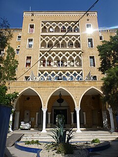
The Ledra Palace Hotel is located in central Nicosia, Cyprus, and until 1974 was one of the largest and most glamorous hotels of the capital. The hotel was designed by the German Jewish architect Benjamin Günsberg and was built between 1947-1949 by Cyprus Hotels Limited at a cost of approx £240,000 Cyprus pounds on what was then called King Edward VII Street, since 1962 Markos Drakos Avenue. The hotel opened on the 8th October 1949 in the presence of British Governor Sir Andrew Wright and Vice Mayor of Nicosia George Poulios. It originally had 94 bedrooms and 150 beds, officially rated as de luxe. All rooms had hot and cold water, central heating and a telephone. Facilities included a conference, reading, bridge and ballroom with orchestra. There were two restaurants, two bars and café. Located within the garden was a swimming pool, paddling pool, children's playground and tennis courts. The hotel had two additional floors added in 1967-1968, thus raising its capacity to 200 rooms and 320 beds.

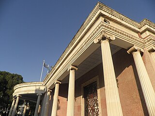
The Embassy of Turkey to the Turkish Republic of Northern Cyprus is located in the Turkish Sector of Nicosia, just outside the walls of the Old City. It is unique in all of the foreign diplomatic missions located in Nicosia in that it is officially accredited to the Turkish Republic of Northern Cyprus (TRNC), rather than the internationally recognized Republic of Cyprus.
Ledra was an ancient city kingdom in Cyprus.
Eleftheria square, is the main square in central Nicosia, Cyprus. It forms the intersection of Ledra and Onasagorou streets with Stasinou, Omirou, Kostaki Pantelidi, Konstandinou Palaiologou and Evagorou avenues. Prior to 1974 the centre of city was considered to be Faneromeni Square.

Notre Dame de Tyre or Our Lady of Tyre is a monastic church in Nicosia, Cyprus. It is located in the Arab Ahmet quarter, in Salahi Şevket Street, formerly known as Victoria Street.

Onasagorou Street is a major shopping street in central Nicosia that runs from Eleftheria square to Faneromeni School. It has been a fashionable shopping street since the 19th century and is currently the home of many high-priced fashion shops. It is currently one of the most expensive strips of real estate in Europe. Base of British Council in Cyprus is located in Onasagorou Street. Onasagorou Street is 0.3 km long.

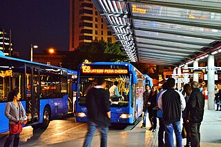
Occupy Buffer Zone (OBZ) was a protest movement that began on October 15, 2011 by Greek Cypriot and Turkish Cypriot activists, in the Ledra/Lokmacı checkpoint, in Nicosia, Cyprus. The movement began with a weekly occupation of the checkpoint, which is located in the buffer zone that divides the island's territory and capital into the self-declared Turkish Republic of Northern Cyprus and the Republic of Cyprus since the Turkish invasion of Cyprus in 1974. On November 19 of 2011 the occupation of the buffer zone became permanent.
The following is a timeline of the history of the city of Nicosia, Cyprus.
Tabakhane is a historic neighborhood, quarter, Mahalla, or parish of central Nicosia, Cyprus, named after the tannery which formerly existed just outside the city walls, near Paphos Gate. Its name is the Arabic and Turkish word for tannery.
Arab Ahmet is a Neighbourhood, Quarter, Mahalla or Parish of Nicosia, Cyprus and the mosque situated therein. Both the Quarter and the mosque are named after Arab Ahmet Pasha, one of the Turkish commanders in the Ottoman conquest of Nicosia. It is spelled Arabahmet in Turkish and Άραπ Άχμετ in Greek.
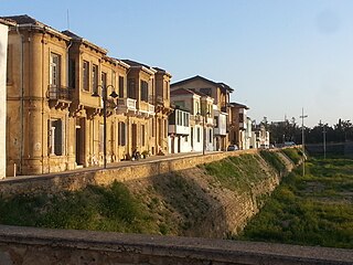
"Laiki Geitonia"(Greek: Λαϊκή Γειτονιά) is a traditional neighbourhood is the pedestrian area of walled city of Nicosia, Cyprus, opposite to the D'Avila bastion and 0.3 km long from the Eleftheria square. Laiki Geitonia's restoration of houses is an example of traditional Cypriot urban architecture. The buildings date from the end of the 18th Century, with building materials being mainly wood, sandstone and mudbrick. It is a pedestrianised area of narrow winding streets, combining residential houses with craft shops, souvenir shops and tavernas.

Köşklüçiftlik is a quarter of North Nicosia in Northern Cyprus. In 2011, it had a population of 2,939.

Dervish Pasha Mansion is a historical mansion and ethnographic museum in the Arab Ahmet quarter of Nicosia, currently located in North Nicosia. It lies on the Beliğ Paşa Street and has two floors. It is considered to be one of the finest examples of Ottoman architecture in Cyprus.