The Canal du Midi is a 240 km (150 mi) long canal in Southern France. Originally named the Canal Royal en Languedoc and renamed by French revolutionaries to Canal du Midi in 1789, the canal is considered one of the greatest construction works of the 17th century.

Pierre-Paul Riquet, Baron de Bonrepos was the engineer and canal-builder responsible for the construction of the Canal du Midi.

The Canal de Garonne, formerly known as Canal latéral à la Garonne, is a French canal dating from the mid-19th century that connects Toulouse to Castets-en-Dorthe. The remainder of the route to Bordeaux uses the river Garonne. It is the continuation of the Canal du Midi which connects the Mediterranean with Toulouse.

A summit-level canal, sometimes called a "watershed canal" or just "summit Canal", is an artificial waterway connecting two separate river valleys. The term refers to a canal that rises to cross a summit then falls down the other side.

The Malpas tunnel carries the Canal du Midi under the d'Ensérune hill in Hérault, France. Excavated in 1679, it was Europe's first navigable canal tunnel and is a monument to the determination of Pierre-Paul Riquet, the chief engineer. It is located in the commune of Nissan-lez-Ensérune near to the archaeological site Oppidum d'Ensérune.

The Canal de Marseille is a major source of drinking water for all of Marseille, the largest city in Provence, France. The canal, along its main artery, is 80 kilometres (50 mi) long and has additional 160 kilometres (99 mi) of minor arteries. Its construction lasted 15 years and was directed by the engineer Franz Mayor de Montricher. The canal became functional on July 8, 1849.

The Canal de l'Ourcq is a 108.1 km (67.2 mi) long canal in the Île-de-France region with 10 locks. It was built at a width of 3.20 m (10.5 ft) but was enlarged to 3.7 m (12 ft), which permitted use by more pleasure boats. The canal begins at Port-aux-Perches near the village of Troesnes, where it splits from the channeled river Ourcq, and flows to the Bassin de la Villette, where it joins the Canal Saint-Martin. Paris requires 380,000 cubic metres of water daily for cleaning the sewer system, gutters, and parks. The Canal de l'Ourcq provides about half of the requirement. Since 1983, the waterway has been designated for use by pleasure craft, and its water is designated for non-drinking uses.

There are 91 working locks on the Canal du Midi along its 240-kilometre (150 mi) course from the Bassin du Thau on the Mediterranean coast to the junction with the Canal lateral a la Garonne in Toulouse. There are a further 13 locks on the 37-kilometre (23 mi) La Nouvelle branch which runs through Narbonne to the Mediterranean at Port-la-Nouvelle. The locks are all under the management of the French navigation authority, Voies navigables de France.

The La Nouvelle branch is a 37.3-kilometre (23.2 mi) branch of the Canal du Midi in Aude, southern France which runs from the Canal du Midi through Narbonne and on to the Mediterranean. It is made up of three waterways: the first 5.1 kilometres (3.2 mi) is the Canal de Jonction from the Canal du Midi to the Aude, the second section is 800 metres (2,625 ft) of the Aude itself and the third is the 31.6 kilometres (19.6 mi) Canal de la Robine which enters the Mediterranean at Port-la-Nouvelle. The La Nouvelle branch is designated a UNESCO World Heritage Site as part of the Canal du Midi and is managed by the French navigation authority, Voies navigables de France.

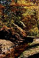
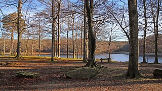
The Bassin de Saint-Ferréol was created as the result of a large earth dam across the mouth of the valley of Laudot stream at St. Ferréol in the Montagne Noire. It was originally proposed by Chevalier de Clerville and accepted by Pierre Paul Riquet as an integral part of the Canal du Midi. Riquet needed to provide a sufficient water reservoir to allow the locks to function year round, even in the dry summer season. The dam was begun on 15 April 1667 and was completed in four years. It was the first dam built specifically to supply water to a navigable canal and was by far the greatest single work of civil engineering undertaken during the building of the Canal du Midi.

The Seuil de Naurouze, or Col de Naurouze, is the highest point of the Canal du Midi in southern France. It is the watershed point identified by Pierre-Paul Riquet when he designed and built the canal. Water falling on the western side of this point flows to the Atlantic Ocean and on the eastern side to the Mediterranean Sea. It is on the border of the department of Haute-Garonne and the department of the Aude.

The Bassin de Naurouze is an octagonal holding tank, created during the building of the Canal du Midi as designed and built by Pierre-Paul Riquet. It was abandoned a few years after construction of the canal because of its recurrent silting problems. The flow of water from the Bassin de Saint-Ferréol joins the Canal du Midi at this point near the Seuil de Naurouze. Riquet hoped to build a city around the basin and also considered building a port. However, it easily filled with silt and its use discontinued. A lawn replaced the empty pool, and it is crossed by a straight path lined with plane trees.

Cesse Aqueduct is one of several aqueducts, or water bridge, created for the Canal du Midi. Originally, the canal crossed the Cesse on the level. Pierre-Paul Riquet, the original architect of the canal, had placed a curved dam 205 metres (673 ft) long and 9.10 metres (29.9 ft) high across the Cesse in order to collect water to make the crossing possible; the aqueduct replaced this dam.
Louis Nicolas de Clerville, a.k.a. Chevalier de Clerville, held many military positions during his life in France in 1610–1677. He was associated with Pierre-Paul Riquet and the building of the Canal du Midi.

The critical feature of the Canal du Midi was to provide sufficient water to ensure that the lock system continued to function, even through the summer months. The first part of this endeavor was the rigole de la plaine. It carried water from the Sor River, at Pontcrouzet, to the Bassin de Naurouze, where the water was to enter the canal. This was done in 1667.
The Bassin de Lampy was created during 1777 and 1781 when a dam was placed on the Lampy Valley in the Aude department in south-central France. The reservoir provides a source of water for the Canal du Midi. It was originally proposed in 1665 by the commission created by Louis XIV of France to evaluate Pierre-Paul Riquet's plan for the canal enterprise.
The balancing of incoming and outgoing water allows the Canal du Midi to operate as it does. Each time a lock operates, large quantities of water are either required to fill it or dump from it into the lower level pound. There must be a constant source of water in order to fill and the excess water dumped must have a place to exit the canal without it overflowing. Being able to provide this water source was one of the most important problems to be solved by Pierre Paul Riquet, its creator.
The Riquet Obelisk is dedicated to the creator of the Canal du Midi, Pierre-Paul Riquet. In 1827, the heirs of Riquet built the monument. The obelisk has a dedication: "To Pierre-Paul Riquet, Baron Bonrepos, author of the Two Seas Canal in Languedoc". It is erected near the site of the former octagonal holding tank, called the Bassin de Naurouze, created during the building of the Canal du Midi.

The Couzon is a river in the Loire department of France, a tributary of the Gier, which in turn is a tributary of the Rhône. A dam on the river, built to serve as a reservoir for the Givors canal, now provides drinking water to the town of Rive-de-Gier.

The Galaube Lake is a reservoir on the Rougeanne River, located between the Tarn (Arfons) and Aude regions in Occitanie, France.