| Rikuchu Kaigan National Park | |
|---|---|
| 陸中海岸国立公園 | |
IUCN category II (national park) | |
northern coastline of Rikuchu Kaigan NP | |
| Location | Honshū, Japan |
| Coordinates | 39°04′19″N141°43′01″E / 39.07194°N 141.71694°E Coordinates: 39°04′19″N141°43′01″E / 39.07194°N 141.71694°E |
| Area | 121.98 km2 |
| Established | May 2, 1955 |
| Governing body | Ministry of the Environment (Japan) |
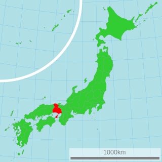
Rikuchū Kaigan National Park(陸中海岸国立公園Rikuchū Kaigan Kokuritsu Kōen) is a national park in the Tōhoku region of Honshū in northern Japan. The park extends for 180 kilometers from north to south along the coastline of the Pacific Ocean from northern Miyagi prefecture to northern Iwate prefecture. The park was created on May 2, 1955, and covers a land area of 121.98 square kilometres (47.10 sq mi).

A national park is a park in use for conservation purposes. Often it is a reserve of natural, semi-natural, or developed land that a sovereign state declares or owns. Although individual nations designate their own national parks differently, there is a common idea: the conservation of 'wild nature' for posterity and as a symbol of national pride. An international organization, the International Union for Conservation of Nature (IUCN), and its World Commission on Protected Areas (WCPA), has defined "National Park" as its Category II type of protected areas.

The Tōhoku region, Northeast region, or Northeast Japan consists of the northeastern portion of Honshu, the largest island of Japan. This traditional region consists of six prefectures (ken): Akita, Aomori, Fukushima, Iwate, Miyagi, and Yamagata.

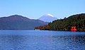
Japan is an island country in East Asia. Located in the Pacific Ocean, it lies off the eastern coast of the Asian continent and stretches from the Sea of Okhotsk in the north to the East China Sea and the Philippine Sea in the south.
Contents
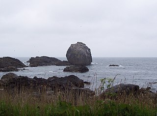
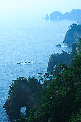
The entire coastline is noted for examples of sea erosion, with numerous rock pillars and islands. The northern coast is an example of an uplifted coastline, and is an area which has been subject to several strong earthquakes and tsunami in recent history. The southern coast is an example of a ria coastline of submerged river valleys, with deep inlets and narrow peninsulas, forming many small bays and coves.

A tsunami or tidal wave,, also known as a seismic sea wave, is a series of waves in a water body caused by the displacement of a large volume of water, generally in an ocean or a large lake. Earthquakes, volcanic eruptions and other underwater explosions (including detonations, landslides, glacier calvings, meteorite impacts and other disturbances above or below water all have the potential to generate a tsunami. Unlike normal ocean waves, which are generated by wind, or tides, which are generated by the gravitational pull of the Moon and the Sun, a tsunami is generated by the displacement of water.

A ria is a coastal inlet formed by the partial submergence of an unglaciated river valley. It is a drowned river valley that remains open to the sea. Typically, rias have a dendritic, treelike outline although they can be straight and without significant branches. This pattern is inherited from the dendritic drainage pattern of the flooded river valley. The drowning of river valleys along a stretch of coast and formation of rias results in an extremely irregular and indented coastline. Often, there are naturally-occurring islands, which are summits of partly submerged, preexisting hill peaks.
Flora includes groves of Japanese red pine, rhododendrons and Rosa rugosa. Fauna includes numerous bird species, including the black-tailed gull and shearwater. In terms of larger animals, there have also been sightings of the kamoshika.

Rhododendron is a genus of 1,024 species of woody plants in the heath family (Ericaceae), either evergreen or deciduous, and found mainly in Asia, although it is also widespread throughout the highlands of the Appalachian Mountains of North America. It is the national flower of Nepal as well as the state flower of West Virginia and Washington. Most species have brightly coloured flowers which bloom from late winter through to early summer.

Rosa rugosa is a species of rose native to eastern Asia, in northeastern China, Japan, Korea and southeastern Siberia, where it grows on the coast, often on sand dunes. It should not be confused with Rosa multiflora, which is also known as "Japanese rose". The Latin word "rugosa" means "wrinkled."
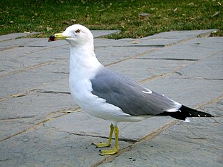
The black-tailed gull is a gull native to shorelines of East Asia.
In 2013 the park was incorporated into Sanriku Fukkō National Park. [1] [2]

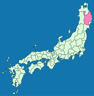
Sanriku Fukkō National Park is a national park extending along the Sanriku Coast of Japan from Hachinohe in Aomori Prefecture through Iwate Prefecture to Kesennuma in Miyagi Prefecture. Created in 2013 in the aftermath of the 2011 Tōhoku earthquake and tsunami, it incorporates the former Rikuchū Kaigan National Park and Tanesashi Kaigan Hashikamidake Prefectural Natural Park. In 2014, the Ministry of the Environment plans to extend the park to include Minami Sanriku Kinkasan Quasi-National Park. Subsequently, the park will be extended to include Kesennuma Prefectural Natural Park, Kenjōsan Mangokuura Prefectural Natural Park, and Matsushima Prefectural Natural Park. At northern part of the national park there is an 8 km long and 200m-high set of cliffs called the Kita Yamazaki; it is said to be Japan's most beautiful coastline.