Jujuy is a province of Argentina, located in the extreme northwest of the country, at the borders with Chile and Bolivia. The only neighboring Argentine province is Salta to the east and south.

Salta is a province of Argentina, located in the northwest of the country. Neighboring provinces are from the east clockwise Formosa, Chaco, Santiago del Estero, Tucumán and Catamarca. It also surrounds Jujuy. To the north it borders Bolivia and Paraguay and to the west lies Chile.
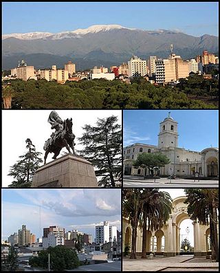
San Salvador de Jujuy, commonly known as Jujuy and locally often referred to as San Salvador, is the capital and largest city of Jujuy Province in northwest Argentina. Also, it is the seat of the Doctor Manuel Belgrano Department. It lies near the southern end of the Humahuaca Canyon where wooded hills meet the lowlands.

La Banda is a city in the province of Santiago del Estero, Argentina. It has about 95,000 inhabitants as per the 2001 census [INDEC], making it the second largest in the province. It is the head town of the Banda Department.

San José de Metán is a city in the south of the province of Salta, Argentina, 160 km from the provincial capital Salta, on National Routes 9 and 34. It has about 28,000 inhabitants as per the 2010 census [INDEC]. It is the head town of the Metán Department.

San Francisco de Tilcara is a city in the province of Jujuy, Argentina, and the head town of the Tilcara Department. It had 6,249 inhabitants at the 2010 census [INDEC]. Traces of human habitation in the area date back more than 10,000 years, making it one of the oldest continuously inhabited settlements of Argentina.
Salvador Mazza or Profesor Salvador Mazza is a city in northern Argentina, in Salta Province, 400 km (249 mi) north of the capital city of Salta, and 55 km (34 mi) from the city of Tartagal on National Route 34 in General José de San Martín Department, on the international border with Bolivia.
Mina Pirquitas is a town and municipality in Jujuy Province in Argentina in the Rinconada Department, in Coyaguaima district, 355 km from the capital of Jujuy, accessed from the town of Abra Pampa by provincial routes 7 and RP 70 (138 km).

Abdón Castro Tolay is a rural municipality and village in the Cochinoca department in Jujuy Province in Argentina. It was founded in October 1919. Its main activity is the raising of llamas and sheep.
Barrios (Jujuy) is a rural municipality and village in Jujuy Province in Argentina.
Coranzuli is a rural municipality and village in Jujuy Province in Argentina.

Susques is a rural municipality and village in Jujuy Province in Argentina.
Laguna Limpia is a village and municipality in Chaco Province in northern Argentina.

Olacapato is a village and rural municipality in Salta Province in northwestern Argentina. Olacapato is one of the highest towns in Argentina. The previous census of 2001 indicated a population of 186 inhabitants, appearing as a rural dispersed population.

Barda del Medio is a village and municipality in Río Negro Province in Argentina. It is located northwest of the province of Río Negro, in the General Roca department, to the north of Patagonia. The population of Barda del Medio is 6.5 km from the municipality of Contralmirante Cordero, along National Route 151, and is under its jurisdiction.
Los Andes is a department located in Salta Province, Argentina. It is the second largest by area in the province, after Rivadavia Department, and its capital is the town of San Antonio de los Cobres.
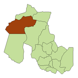
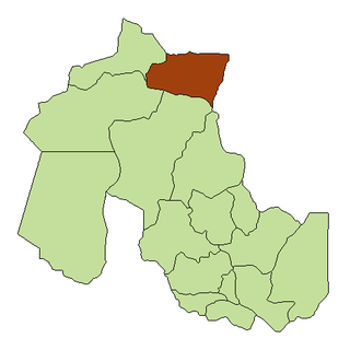
Cochinoca is a department located in the Jujuy Province, (Argentina). According to 2005 INDEC estimates, it had a population of 13,301 inhabitants.

Rinconada is a department in the province of Jujuy in the Argentina. According to INDEC its population in 2010 was 2,489 inhabitants. Its main town is Rinconada. The town of Mina Pirquitas represents the highest point in Argentina, standing at 4,271 m above sea level.
Cusi Cusi is a village located in the Santa Catalina and Rinconada Department of Jujuy Province, Argentina.

Laguna de los Pozuelos Natural Monument is a nature preservation reserve located in the Jujuy province, in the Puna region, Argentina. It covers an area of 16,000 hectares and is at an altitude of 4,000 metres (13,000 ft) above sea level. It is part of the Puna Seca Central Andean Ecoregion. The reserve was created in 1980, under Provincial Law Nº 3,749/80, aiming to preserve the steppe environment and its lagoon, including the region's typical fauna.