Jujuy is a province of Argentina, located in the extreme northwest of the country, at the borders with Chile and Bolivia. The only neighboring Argentine province is Salta to the east and south.
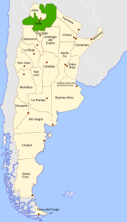
Salta is a province of Argentina, located in the northwest of the country. Neighboring provinces are from the east clockwise Formosa, Chaco, Santiago del Estero, Tucumán and Catamarca. It also surrounds Jujuy. To the north it borders Bolivia and Paraguay and to the west lies Chile.

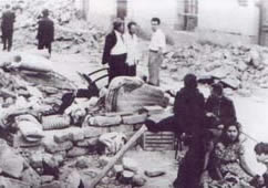
The 1944 San Juan earthquake took place in the province of San Juan, in the center-west area of Argentina, a region highly prone to seismic events. This moderate to strong earthquake destroyed a large part of San Juan, the provincial capital, and killed 10,000 of its inhabitants, 10% of its population at the time. One third of the province population became homeless. It is acknowledged as the worst natural disaster in Argentine history.
The 1861 Mendoza earthquake occurred in the province of Mendoza, Argentina on 20 March at 11:30 PM. It had a magnitude of 7.2 on the Ms scale and an intensity of IX in the Mercalli scale. Its hypocenter was located at an estimated depth of 30 kilometres (19 mi).
The 1948 Salta earthquake took place in the Argentinian province of Salta on 25 August at 03:09:28 local time The shock was 7.0 on the moment magnitude scale and had a maximum Mercalli Intensity of IX (Violent). Property damage and casualties occurred in several towns in the east and southeast of Salta, and also in northern Tucumán and Jujuy, affecting the capitals of both. It was the last major earthquake recorded in the Argentine Northwest until the 2010 Salta earthquake.
The 1894 San Juan earthquake took place in the province of San Juan, Argentina, on 27 October 1894, at about 07:30 PM. It was the most powerful earthquake recorded in Argentina, with magnitude 7.5 on the surface wave magnitude scale. Its epicenter was located to the northwest of San Juan, approximately at 29°48′S69°00′W, and at a depth of 30 km.
The 1817 Santiago del Estero earthquake took place in the province of Santiago del Estero, Argentina, on 4 July at about 05:30 PM. It was estimated to be 7.0 on the Richter magnitude scale. Its epicenter was at 28°00′S64°30′W, at a depth of 30 km.
The 1863 Jujuy earthquake took place in the province of Jujuy, Argentina on 14 January at about 11:00 (UTC). It had an estimated magnitude of 6.4 and its epicenter was at 23°36′S65°00′W, at a depth of about 50 kilometres (31 mi).
San Carlos is a head village of the department of San Carlos, Province of Salta, Argentina. San Carlos is a historic village in Calchaquíes Valleys located at the National Route 40, 27 km from Cafayate.

Los Andes is a department located in Salta Province, Argentina. It is the second largest by area in the province, after Rivadavia Department, and its capital is the town of San Antonio de los Cobres.
The 1844 Salta earthquake took place in the Province of Salta, in the Republic of Argentina, on 18 October at 23:00 UTC. It registered a magnitude of 6.5 on the Richter magnitude scale. The earthquake was located at a depth of 30 km.
The 1927 Mendoza earthquake took place in Mendoza Province, in the Republic of Argentina, on 14 April at 06:23:28 UTC. It registered a magnitude of 7.1 on the Richter magnitude scale. The earthquake was located at a depth of 110 kilometres (68 mi).
The department of Tafí Viejo is a department of the province of Tucumán (Argentina), created in 1907 by the reform of the provincial constitution, which divided the old department Tafí. Its head is the homonymous city. Bordered on the north by the department Trancas, east to Burruyacú and Cruz Alta, south of Capital, Yerba Buena and Lules, and west to Tafí del Valle.

Pairique Chico is a village in Jujuy Province, Argentina, in the Susques Department.