
Kongsøya is an island in Svalbard, Norway. It is the largest of the islands in King Charles Land. Its area is 191 square kilometres (74 sq mi). The other main island in the chain is Svenskøya.

Nathorst Land is the land area between Van Keulenfjorden and Van Mijenfjorden on Spitsbergen, Svalbard.
Torell Land is a land area at the southeast part of Spitsbergen, Svalbard. It is named after Otto Martin Torell. Two glaciers, Hornbreen and Hambergbreen, divide Torell Land from Sørkapp Land.

Heer Land is a land area on the east coast of Spitsbergen, Svalbard. It is bordered by Rindersbukta to the southwest, Braganzavågen and Kjellströmdalen to the northwest, Storfjorden to the east and southeast, and Torell Land to the south. It is named after paleobotanist Oswald Heer. Heer Land mainly consist of glaciers and nunataks.
Braganzavågen is a bay located in the inner northern branch of Van Mijenfjorden, at Spitsbergen, Svalbard, within Heer Land and Nordenskiöld Land. The valley Kjellströmdalen debouches into the bay. The mining settlement Sveagruva is located at the western side of Braganzavågen, below the mountain Liljevalchfjellet.
Liljevalchfjellet is a mountain ridge in Nordenskiöld Land at Spitsbergen, Svalbard. It has a length of about 10.5 kilometres, and the highest point is 943 m.a.s.l. The ridge is located between the bay Braganzavågen and the valley Gustavdalen. It is named after businessperson Carl Fredrik Liljevalch. The mining settlement Sveagruva is located at the plain between Braganzavågen and Liljevalchfjellet.
Reindalselva is a river in Nordenskiöld Land at Spitsbergen, Svalbard. The river flows through the valley of Reindalen, starting from the mountain pass Reindalspasset, and ending into the bay Kaldbukta in Van Mijenfjorden. It has created one of Svalbard's largest river deltas. Among its tributary rivers are Semmeldalselva and Tverrdalselva.

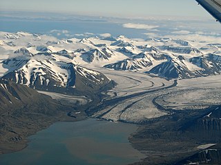
Fridtjovbreen is a glacier in Nordenskiöld Land at Spitsbergen, Svalbard. It has a length of about 14 kilometers, and debouches into the bay Fridtjovhamna at the northern side of Van Mijenfjorden. The name stems from a hunting vessel used during the Torell expedition to Spitsbergen. The lower part of the glacier is included in the Nordenskiöld Land National Park.
Isbjørnhamna is a bay in Wedel Jarlsberg Land at Spitsbergen, Svalbard. It is located between Wilczekodden and Hansbreen, at the northern side of Hornsund. The bay is named after the Norwegian sealing vessel Isbjørn. A Polish Polar Station is located in Isbjørnhamna.
Erdmannbreen is a glacier in Nordenskiöld Land at Spitsbergen, Svalbard. It is named after Swedish geologist Axel Joachim Erdmann. The glacier has a length of about six kilometers, and is surrounded by the mountains of Malmberget, Ytterdalsgubben and Kosterfjellet. The river of Ytterdalselva originates from Erdmannbreen and flows through the valley of Ytterdalen to the bay of Van Muydenbukta.
Lågnesflya is a coastal plain in Nordenskiöld Land at Spitsbergen, Svalbard. It is located between the lakes of Femvatna and Andungen in the north and Ytterdalselva in the southeast, the bays of Van Muydenbukta and Marvågen, and the hills of Lågnesrabbane. The pyramid shaped landmark of Ytterdalsgubben is located between Lågnesflya and the glacier of Erdmannbreen.
Bassøefjellet is a mountain in Nathorst Land at Spitsbergen, Svalbard. It has peaks with heights of 1,081 and 953 m.a.s.l. respectively. The mountain is named after Norwegian civil servant and Governor of Svalbard, Johannes Gerckens Bassøe. It is located between Van Mijenfjorden and Van Keulenfjorden, west of Langlifjellet and south of Løyndbreen, with the glaciers of Lundbreen and Kvitskarvbreen to the south. East of the mountain is the valley of Bromelldalen.
Svalisbreen is a glacier in Sørkapp Land at Spitsbergen, Svalbard. It has a length of about 12.5 kilometers, extending from the mountain pass of Svanhildpasset to Hornbreen, towards the bay of Brepollen, the inner part of Hornsund.

Storbreen is a glacier in Torell Land at Spitsbergen, Svalbard. It has a length of about fifteen kilometers, and debouches towards the bay of Brepollen, the inner part of Hornsund.

Scheelebreen is a glacier in Nathorst Land at Spitsbergen, Svalbard. It has a length of about sixteen kilometers, and is located between the mountains of Vriompeisen and Fagerstafjella. The glacier is named after Swedish chemist Carl Wilhelm Scheele.
Vriompeisen is a mountain area in Nathorst Land at Spitsbergen, Svalbard. It comprises the peaks of Kroknosa, Peisen and Peisnosa, which form a U-shape surrounding the glacier of Peisbreen. Vriompeisen is located between the glaciers of Paulabreen, Scheelebreen, Klubbebreen and Sokkbreen.
Paulabreen is a glacier in Nathorst Land and Heer Land at Spitsbergen, Svalbard. It has a length of about fifteen kilometers, extending from the mountain of Kjølberget to the bay of Rindersbukta. The glacier is named after Paula, the wife of shipmaster Richard Ritter von Barry. Paulabreen borders to the mountain area of Vriompeisen, and the mountain of Hollertoppen. A tributary glacier is Bakaninbreen.
Bakaninbreen is a glacier in Heer Land at Spitsbergen, Svalbard. It has a length of about 9.5 kilometers, and merges with the glacier of Paulabreen. The glacier is named after a member of the Swedish-Russian Arc-of-Meridian Expedition. The mountain of Hollertoppen is located between Bakaninbreen and Ragna-Mariebreen.
Steindolpbreen is a glacier in Nathorst Land at Spitsbergen, Svalbard. It extends from Juvtinden and the eastern side of Steindolptoppen to Snøkuvbreen. North of the glacier are the mountains of Rånekampen and Vengefjellet.
Kapp Toscana is a headland at the southern side of Van Keulenfjorden in Wedel Jarlsberg Land at Spitsbergen, Svalbard. It is named after an Austrian family. West of the headland is the bay of Bourbonhamna, extending from Kapp Toscana to Kapp Madrid. East of the headland is the bay of Ingebrigtsenbukta, extending from Kapp Toscana to Ålesundneset.
