Ringley

Last updated

Ringley is near Kearsley in Greater Manchester, England, on the east bank of the River Irwell. [1] Its Anglican church is St Saviour's. [2] Ringley is linked by road to Stoneclough by the A667 road which crosses the River Irwell on Ringley road bridge which is a short distance upstream from the 17th century Ringley Old Bridge.

Contents

Ringley Old Bridge

Ringley Old Bridge Ringley old bridge.jpg
Ringley Old Bridge

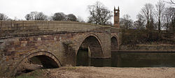
Ringley is connected to Stoneclough across the River Irwell by Ringley Old Bridge which dates from the 17th century. Nowadays it is only in use for pedestrians and cyclists. Very close to the Ringley side of the bridge are the ancient village stocks. The bridge is a Grade II listed building.

St Saviour's Church

St Saviour's Church St Saviour's Church, Kearsley.jpg
St Saviour's Church

St Saviour's Church stands close to the old bridge. Founded in 1625, the present building dates from 1854 and is a Grade II listed building.

Primary school

St Saviour C.E. Primary School stands close to the church it is named after.

Public house

Ringley has just one public house, the Horseshoe, which stands on Fold Road next to the church. The pub's origins go back as far as 300 years. It is owned by Blackburn's Thwaites Brewery and has an M26 postcode.

See also

Related Research Articles

<span class="mw-page-title-main">Radcliffe, Greater Manchester</span> Town in Greater Manchester, England

Radcliffe is a market town in the Metropolitan Borough of Bury, Greater Manchester, England. It lies in the Irwell Valley 7 miles (11 km) northwest of Manchester and 3 miles (5 km) southwest of Bury and is contiguous with Whitefield to the south. The disused Manchester Bolton & Bury Canal bisects the town.

<span class="mw-page-title-main">Pendlebury</span> Town in Greater Manchester, England

Pendlebury is a town in the City of Salford, Greater Manchester, England. The population at the 2011 Census was 13,069. It lies 4 miles (6 km) north-west of Manchester, 3 miles (5 km) north-west of Salford and 6 miles (10 km) south-east of Bolton.

<span class="mw-page-title-main">Warburton, Greater Manchester</span> Human settlement in England

Warburton is a village and civil parish within the Metropolitan Borough of Trafford in Greater Manchester, England. Historically in Cheshire, Warburton lies on the south bank of the River Mersey between the borough of Warrington and Greater Manchester. In the 21st century, the village remains predominantly rural. Altrincham is the nearest town. According to the 2001 census, the parish had a population of 286.

<span class="mw-page-title-main">Little Lever</span> Village in Greater Manchester, England

Little Lever is a village in the Metropolitan Borough of Bolton, Greater Manchester, England. Within the Historic County of Lancashire, it is 2 miles (3.2 km) southeast of Bolton, 2 miles (3.2 km) west of Radcliffe and 4 miles (6.4 km) southwest of Bury. In the 19th century, the population was employed in cotton mills, paper mills, bleach works, terracotta works, a rope works and numerous collieries.

<span class="mw-page-title-main">Kearsley railway station</span> Railway station in Greater Manchester, England

Kearsley railway station serves the town of Kearsley and the outlying villages of Stoneclough, Prestolee and Ringley in Greater Manchester, England. It was originally named Stoneclough.

<span class="mw-page-title-main">Clifton, Greater Manchester</span> Suburb in Greater Manchester

Clifton is a suburb of Swinton in the City of Salford in Greater Manchester, England. It lies along the edge of Irwell Valley in the north of the City of Salford. Historically in Lancashire, it was a centre for coal mining, and once formed part of the Municipal Borough of Swinton and Pendlebury.

<span class="mw-page-title-main">Prestolee</span> Village in Greater Manchester

Prestolee is a small village in Kearsley, within the Metropolitan Borough of Bolton, in Greater Manchester, England. It lies on the River Irwell and is one of a cluster of villages between Bolton and Kearsley, which includes Stoneclough and Ringley.

<span class="mw-page-title-main">Kearsley</span> Town in Bolton, Greater Manchester, England

Kearsley is a town in the Metropolitan Borough of Bolton, Greater Manchester, England. The population at the 2011 census was 14,212. Within the Historic County of Lancashire, it lies 8 miles (13 km) northwest of Manchester, 5 miles (8 km) southwest of Bury and 3+34 miles (6 km) south of Bolton.

<span class="mw-page-title-main">Barton upon Irwell</span> Suburb in Greater Manchester, England

Barton upon Irwell is a suburb of the City of Salford, Greater Manchester, England, with a population of 12,462 in 2014.

<span class="mw-page-title-main">Stoneclough</span> Human settlement in England

Stoneclough is a suburban area of Kearsley in the Metropolitan Borough of Bolton, Greater Manchester, England. It is located 3.7 miles (6 km) south-east of Bolton, 4 miles (6 km) south-west of Bury and 7.9 miles (13 km) north-west of Manchester. It is located on the banks of the River Irwell to the southeast of Bolton.

<span class="mw-page-title-main">Ordsall, Greater Manchester</span> Suburb of the City of Salford, England

Ordsall is an inner city suburb of Salford, Greater Manchester, England. The population at the 2011 census was 14,194. It lies chiefly to the south of the A57 road, close to the River Irwell, the main boundary with the city of Manchester, Salford Quays and Manchester Ship Canal, which divides it from Stretford.

<span class="mw-page-title-main">Outwood Viaduct</span>

Outwood Viaduct is a Grade II listed railway viaduct crossing the River Irwell in Radcliffe, Greater Manchester. Following a period of disuse, it was restored and opened to the general public as a footpath.

<span class="mw-page-title-main">St Saviour's Church, Ringley</span> Church in Greater Manchester, England

St Saviour's Church is in Ringley, Kearsley, near Bolton, Greater Manchester, England. It is an active Anglican parish church in the deanery of Bolton, the archdeaconry of Bolton and the diocese of Manchester. Its benefice is united with those of St Peter's, Farnworth, St John the Evangelist, Farnworth and Holy Trinity, Prestolee. The church is recorded in the National Heritage List for England as a designated Grade II listed building.

<span class="mw-page-title-main">Ringley Old Bridge</span>

Ringley Old Bridge is an ancient stone bridge in Kearsley near Bolton, England which crosses the River Irwell, linking Ringley with Stoneclough. It has two large semi-circular arches, and a third smaller arch, for the tow path. It is a Grade II* structure, listed on 19 August 1986.

<span class="mw-page-title-main">St John the Evangelist's Church, Farnworth</span> Church in Greater Manchester, England

St John the Evangelist's Church is in Church Street, Farnworth, Greater Manchester, England. It is an active Anglican parish church in the deanery of Bolton, the archdeaconry of Bolton, and the diocese of Manchester. Its benefice is united with those of St Peter, Farnworth, Holy Trinity, Prestolee, and St Saviour, Ringley. The church is recorded in the National Heritage List for England as a designated Grade II listed building.

<span class="mw-page-title-main">Victoria Bridge, Manchester</span> Bridge in Manchester, England

Victoria Bridge is a stone arch bridge in Greater Manchester, England. Completed in 1839 and named after Queen Victoria, it crosses the River Irwell, connecting Salford to Manchester.

<span class="mw-page-title-main">Blackfriars Bridge, Manchester</span> Bridge in Manchester, England

Blackfriars Bridge is a stone arch bridge in Greater Manchester, England. Completed in 1820, it crosses the River Irwell, connecting Salford to Manchester.

<span class="mw-page-title-main">Grade I listed buildings in Greater Manchester</span>

There are 48 Grade I listed buildings in Greater Manchester, England. In the United Kingdom, the term listed building refers to a building or other structure officially designated as being of special architectural, historical or cultural significance; Grade I structures are those considered to be "buildings of exceptional interest". In England, the authority for listing under the Planning Act 1990 rests with Historic England, a non-departmental public body sponsored by the Department for Culture, Media and Sport.

<span class="mw-page-title-main">Kearsley Mill</span>

Kearsley Mill is a 240,000 sq ft (22,000 m2), late period cotton mill located in the small village of Prestolee in Kearsley, Greater Manchester, part of the historic county of Lancashire. A near complete example of Edwardian mill architecture, the building now functions as headquarters for a number of businesses and is still used in the continued manufacturing and distribution of textiles by Richard Haworth Ltd Est (1876), part of the Ruia Group. The mill is a Grade II listed building.

Kearsley is a town and an unparished area in the Metropolitan Borough of Bolton, Greater Manchester, England, and it includes the area of Ringley and the village of Prestolee. The town contains 21 listed buildings that are recorded in the National Heritage List for England. Of these, one is listed at Grade II*, the middle of the three grades, and the others are at Grade II, the lowest grade. The Manchester and Bolton Railway was built through the area, and two railway bridges are listed. Also passing through the area are the Manchester Bolton and Bury Canal, which is now disused, and the River Irwell; listed buildings associated with these are bridges, an aqueduct, and milestones. The other listed buildings include a set of stocks, a house later used as a social club, two churches, a tower remaining from a demolished church, and a former spinning mill.

References

53°32′35″N2°21′22″W / 53.543°N 2.356°W / 53.543; -2.356