
Uldalsåna is a lake on the border of the municipalities of Birkenes and Froland in Aust-Agder county, Norway. It is part of the Tovdalselva river drainage basin. On the southeastern end of the lake, there is a hydroelectric dam which releases water into the waterfall, Hanefoss, on its way down to the lake Herefossfjorden near the village of Herefoss. The lake is fed by the rivers Rettåna and Skjeggedalsåna. The lake Nystølfjorden flows into the river Skjeggedalsåna.
Homstølvatnet or Eptevatn is a lake in the far western part of the municipality of Froland in Aust-Agder county, Norway. It is located about 12 kilometres (7.5 mi) east of the village of Byglandsfjord (in Bygland municipality) and about 16 kilometres (9.9 mi) northwest of the village of Mykland in Froland. The lake was expanded in 1973 when a dam was built at the south end of the lake Eptevatn for the purposes of hydroelectric power generation. The dam made the lake larger so that it now includes the formerly separate lake Homstølvatnet as one large lake. The lake is now 3.92-square-kilometre (1.51 sq mi) large and it holds about 44 cubic megametres (3.6×10¹⁶ acre⋅ft) as a reservoir for the power station.
Høvringsvatnet or Høvringsvatn is a lake in the municipality of Evje og Hornnes in Aust-Agder county, Norway. It's located about 10 kilometres (6.2 mi) northeast of the village area of Evje and about 6 kilometres (3.7 mi) southeast of the village area of Byglandsfjord. The lake Homstølvatnet in Froland municipality is located about 5 kilometres (3.1 mi) to the northeast.
Nelaug is a lake in the municipalities of Froland and Åmli in Aust-Agder county, Norway. The 10 kilometres (6.2 mi) lake is formed by a dam which regulates a hydroelectric power plant on the Nidelva river. The village of Nelaug is located near the dam in Froland municipality. The lake is located about 11 kilometres (6.8 mi) south of the village of Åmli, about 15 kilometres (9.3 mi) southeast of the village of Dølemo, and about 20 kilometres (12 mi) north of Blakstad.

Bøylestad is a village in Froland municipality in Aust-Agder county, Norway. The village is located along the river Nidelva about 10 kilometres (6.2 mi) northeast of the village of Blakstad–Osedalen and about 2.5 kilometres (1.6 mi) south of the village of Bøylefoss. The population of Bøylestad (2001) was 214.

Bøylefoss is a village in Froland municipality in Aust-Agder county, Norway. The village is located along the river Nidelva at the location of the Bøylefoss waterfall. The river is dammed so the waterfall is no longer visible. The water is piped downhill to the Bøylefoss power plant on the shore of the river. There is a very small village near the power plant also called Bøylefoss. The nearby village of Bøylestad lies about 2.5 kilometres (1.6 mi) south of Bøylefoss.

Frolands verk is a small village area in Froland municipality in Aust-Agder county, Norway. The village is located along the Norwegian County Road 42, almost 5 kilometres (3.1 mi) west of the municipal centre of Blakstad/Osedalen and about 7 kilometres (4.3 mi) southeast of the village of Mjåvatn. The lake Trevann lies just south of the village.
Heldalsmo is a village in Froland municipality in Aust-Agder county, Norway. The village is located along the Sørlandsbanen railway line, about 4 kilometres (2.5 mi) southwest of the lake Nelaug. The village is only accessible by rail from Hynnekleiv to the west or Nelaug to the east, or by the Norwegian County Road 152 which runs to the south through Jomås and on to Blakstad.
Hinnebu is a village in Froland municipality in Aust-Agder county, Norway. The village is located along the Norwegian County Road 42, about 5.5 kilometres (3.4 mi) southeast of the village of Hynnekleiv and about 4 kilometres (2.5 mi) north of the village of Mjåvatn.
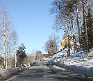
Hynnekleiv is a village in Froland municipality in Aust-Agder county, Norway. The village is located at the junction of the Norwegian National Road 41 and the Norwegian County Road 42. The Sørlandsbanen railway line runs through the village as well, but the railway station here was closed in 2003. The river Tovdalselva flows past the village on the west side.
Jomås is a village in Froland municipality in Aust-Agder county, Norway. The village is located along the Norwegian County Road 152, about half-way between the villages of Heldalsmo and Løvjomås. The village of Blakstad lies about 10 kilometres (6.2 mi) south of Jomås.
Lauvrak is a village in Froland municipality in Aust-Agder county, Norway. The village is located along the Norwegian County Road 413, about 5 kilometres (3.1 mi) north of the village of Mykland.
Libru is a village in Aust-Agder county, Norway. The village is located on the border of the municipalities of Arendal and Froland. The village lies at the southern end of the lake Assævannet, about 4 kilometres (2.5 mi) southeast of Blakstad in Froland and about 6 kilometres (3.7 mi) from the town of Arendal. The village of Rise lies along the Arendalsbanen railway line, about 3 kilometres (1.9 mi) to the southwest of Libru.
Løvjomås is a village in Froland municipality in Aust-Agder county, Norway. The village is located about 5 kilometres (3.1 mi) northwest of the village of Froland, where Froland Church is located, and about 7 kilometres (4.3 mi) south of the village of Jomås.
Mjølhus is a village in Froland municipality in Aust-Agder county, Norway. The village is located on the west shore of the river Nidelva, just north of the municipal centre of Blakstad-Osedalen.
Mjåvatn is a village in Froland municipality in Aust-Agder county, Norway. The village is located along Norwegian County Road 42, about 10 kilometres (6.2 mi) northwest of the village of Blakstad-Osedalen, about 4 kilometres (2.5 mi) south of the village of Hinnebu, and about 10 kilometres (6.2 mi) east of the village of Herefoss.

Østre Agder is a district or region in Aust-Agder county in southern Norway. The district covers the eastern, coastal areas of the county including the eight municipalities of Arendal, Tvedestrand, Risør, Grimstad, Gjerstad, Vegårshei, Åmli, and Froland. The city of Arendal is the largest city in the region. Other cities in the district include Tvedestrand, Grimstad, and Risør. This region is bounded by Telemark county to the north, by the Setesdal region to the northwest, and by the Kristiansand Region to the southwest.

Froland Church is a parish church in Froland municipality in Aust-Agder county, Norway. It is located in the village of Froland, on the shore of the river Nidelva. It is the church for the Froland parish which is part of the Arendal prosti (deanery) in the Diocese of Agder og Telemark. The white, wooden church was built in 1718 to replace an earlier church that was torn down in 1715. The present church seats about 295 people.

Froland is a small village in Froland municipality in Aust-Agder county, Norway. The village is located on the western shore of the river Nidelva, just about 3 kilometres (1.9 mi) north of the municipal centre of Blakstad. The village is the site of Froland Church, the main church for the municipality. The Arendalsbanen railway line runs through the village, stopping at Froland Station.


