
Andøy is the northernmost municipality in Nordland county, Norway. It is part of the Vesterålen archipelago. The main island in the municipality is Andøya. The administrative centre of the municipality is the village of Andenes. Other villages in the municipality include Bjørnskinn, Bleik, Dverberg, Fiskenes, Fornes, Nordmela, Risøyhamn, Skarstein, Å, Åknes, and Åse.

Åse is a village in Andøy Municipality in Nordland county, Norway. The village is located along the Norwegian County Road 82 on the southeastern coast of the island of Andøya, along the Andfjorden. The village of Å lies about 5 kilometres (3.1 mi) to the north, and the villages of Bjørnskinn and Risøyhamn lie about 8 kilometres (5.0 mi) to the southwest.

Hinnøya is the fourth largest island in Norway. The 2,204.7-square-kilometre (851.2 sq mi) lies just off the western coast of Northern Norway. The island sits on the border of Nordland and Troms counties. The western part of the island is in the district of Vesterålen, the southwestern part is in the Lofoten district, the southeastern part is in the Ofoten district, and the northeastern part is in Southern Troms.
Andenes (help·info) is the administrative centre of Andøy Municipality which is located in the Vesterålen district of Nordland county, Norway. The village of Andenes is the northernmost settlement of the island of Andøya. To the east is the island of Senja, and to the west the endless horizon of the North Atlantic Ocean. Andenes Lighthouse sits along the harbor and can be seen for long distances. Andøya Airport, Andenes is located just south of the village, off of Norwegian County Road 82.

Andøya is the northernmost island in the Vesterålen archipelago, situated about 300 kilometres (190 mi) inside the Arctic circle. Andøya is located in Andøy Municipality in Nordland county, Norway. The main population centres on the island include the villages of Andenes, Bleik, and Risøyhamn.

Vesterålen is a district and archipelago in Nordland county, Norway. It is located just north of the Lofoten district and archipelago and west of the town of Harstad. It is the northernmost part of Nordland county, including the municipalities of Andøy, Bø, Hadsel, Sortland, and Øksnes.

Skarstein or Skardstein is a village in Andøy Municipality in Nordland county, Norway. The village is located along Norwegian County Road 82 on the northeastern part of the island of Andøya, along the Andfjorden. The village of Andenes lies about 10 kilometres (6.2 mi) to the north, and the village of Fiskenes lies about 2 kilometres (1.2 mi) to the northeast.

The Andøy Bridge is a cantilever road bridge that crosses the Risøysundet strait between the islands of Andøya and Hinnøya in Andøy Municipality in Nordland county, Norway. The northern end of the bridge is located in the village of Risøyhamn. The bridge is 750 metres (2,460 ft) long, the main span is 110 metres (360 ft), and the maximum clearance to the sea is 30 metres (98 ft). The bridge has 21 spans.
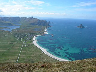
Bleik is a fishing village in Andøy Municipality in Nordland county, Norway. The village is located on the northwestern part of the island of Andøya, about 10 kilometres (6.2 mi) southwest of the village of Andenes.

Bjørnskinn is a village in Andøy Municipality in Nordland county, Norway. The village of Bjørnskinn lies along the southern part of the island of Andøya, about 2 kilometres (1.2 mi) northwest of the larger village of Risøyhamn. The village is the site of Bjørnskinn Church which serves the southern part of the municipality. The village was also the administrative centre of the old municipality of Bjørnskinn which existed from 1924 until its dissolution in 1964.
Bleiksvatnet is a lake in Andøy Municipality in Nordland county, Norway. The 1.74-square-kilometre (0.67 sq mi) lake is located just south of the village of Bleik on the island of Andøya. The lake sits at an elevation of 28 metres (92 ft) above sea level. The Bleikmorenen nature reserve is located on the northern shore of the lake.
Skogvollvatnet is a lake in Andøy Municipality in Nordland county, Norway. The 2.74-square-kilometre (1.06 sq mi) lake lies on the west coast of the island of Andøya. There is a 150-to-200-metre wide isthmus of land between the lake and the ocean on the west side of the lake. The tiny village of Skogvoll lies on the isthmus between the lake and the ocean.
Dverberg is a small village in Andøy Municipality in Nordland county, Norway. It is located on the east coast of the island of Andøya, along the Andfjorden, about 30 kilometres (19 mi) south of the large village of Andenes. The village of Dverberg is also called Myre. Dverberg Church is a wooden, octagonal church built in 1843, located on the north end of the village.
Fiskenes is a village in Andøy Municipality in Nordland county, Norway. The village is located on the northeastern part of the island of Andøya, along the Andfjorden. The village of Andenes lies about 10 kilometres (6.2 mi) to the north, and the village of Skarstein lies about 2 kilometres (1.2 mi) to the south. The population is approximately 50 people.
Å is a village in Andøy Municipality in Nordland county, Norway. The village is located on the east coast of the island of Andøya along the Andfjorden. The village of Dverberg lies about 8 kilometres (5.0 mi) to the north and the village of Åse lies about 5 kilometres (3.1 mi) to the south. Its sign is often replaced due to people stealing it for novelty purposes.
Åknes is a village in Andøy Municipality in Nordland county, Norway. The village is located on the southwestern part of the island of Andøya, along the Gavlfjorden. The village is located about 10 kilometres (6.2 mi) southwest of the village of Bjørnskinn.

Risøysundet is a strait between the islands of Andøya and Hinnøya in the Vesterålen archipelago in Norway. It is located in Andøy Municipality in Nordland county. The 24-kilometre (15 mi) long strait has only one road crossing: the Andøy Bridge as part of the Norwegian County Road 82 connecting the villages of Risøyhamn and Dragnes.

Andenes (help·info) is a former municipality in Nordland county, Norway. The 71-square-kilometre (27 sq mi) municipality existed from 1924 until its dissolution in 1964. The municipality included the northern part of the island of Andøya as well as many small surrounding islets and skerries in what is now Andøy Municipality. The administrative centre was the village of Andenes where the Andenes Church is located.
Dverberg is a former municipality in Nordland county, Norway. The municipality existed from 1838 until its dissolution in 1964. The municipality encompassed areas on the island of Andøya in what is now Andøy Municipality. Starting out at about 616 square kilometres (238 sq mi) in 1838, it was reduced in size in 1924. Upon its dissolution in 1964, the municipality was only 279 square kilometres (108 sq mi). The administrative centre was the village of Dverberg where Dverberg Church is located.
Bjørnskinn is a former municipality in Nordland county, Norway. The 310-square-kilometre (120 sq mi) municipality existed from 1924 until its dissolution in 1964. The municipality was centered around the Risøysundet strait. It encompassed the southern part of the island of Andøya and the northern part of the island of Hinnøya in the southern part of what is now Andøy Municipality. The administrative centre was the small village of Bjørnskinn where Bjørnskinn Church is located. The largest village in Bjørnskinn was the village of Risøyhamn.


