River Cong (Ireland)

Last updated

River Cong
Cong River, County Mayo.jpg
River Cong
Ireland relief location map.png
Red pog.svg
Source of the River Cong within County Mayo
Native nameAbhainn Chonga (Irish)
Location
Country Ireland
County County Galway
County Mayo
Province Connacht
Physical characteristics
SourceVillage of Cong, County Mayo
Mouth Flows into Lough Corrib
  coordinates
53°31′58″N9°17′04″W / 53.53276°N 9.28451°W / 53.53276; -9.28451
Length1 mi (1.6 km)
Discharge 
  average37.6 m3/s (1,330 cu ft/s)

The River Cong (Irish : Abhainn Chonga) [1] is a short river of moderate flow in Ireland, primarily in County Mayo but also touching County Galway.

Contents

Course

The river issues from the large springs in the village of Cong, County Mayo, springs for which the village is justly famous. [2] The springs are fed by underground flow through caverns in the limestone bedrock of the district from Lough Mask, a little over four miles (6.4 km) to the north. [3] The river is only about one mile (1.6 km) long but some 100 yards (91 m) wide in places. It is divided by an island at one point. It flows strongly past Ashford Castle and into Lough Corrib. [4]

Recreation

The river is popular with fishermen, having a State salmon hatchery and a strong spring salmon run. The peak of the spring run is in April and then the grilse come in May. June to early July are particularly good, and salmon are taken in lesser numbers for the rest of the season. The river also holds stocks of ferox trout (brown trout). The upper stretch has open access, while the lower part is managed by Ashford Castle, and local gillies are available. [4] [5]

The Cong Canal

The Cong Canal was designed to provide a navigable link between Lough Corrib at the village of Cong and Lough Mask, six kilometres to the north. The canal was abandoned unfinished in 1854. The canal was brought to wide public attention in 1872 by the writer William Wilde [6] who coined the name ‘The Dry Canal’. The canal has become something of a tourist attraction in the village of Cong, County Mayo.

Related Research Articles

<span class="mw-page-title-main">River Shannon</span> Longest river in the British Isles

The River Shannon is the major river on the island of Ireland, and at 360 km in length, is the longest river in the British Isles. It drains the Shannon River Basin, which has an area of 16,900 km2 (6,525 sq mi), – approximately one fifth of the area of Ireland.

<span class="mw-page-title-main">Lough Corrib</span> Lake in the west of Ireland

Lough Corrib is a lake in the west of Ireland. The River Corrib or Galway River connects the lake to the sea at Galway. It is the largest lake within the Republic of Ireland and the second largest on the island of Ireland. It covers 176 km² and lies mostly in County Galway with a small area of its northeast corner in County Mayo.

<span class="mw-page-title-main">Arthur Guinness, 1st Baron Ardilaun</span> Irish businessman, politician and philanthropist

Arthur Edward Guinness, 1st Baron Ardilaun, 2nd Baronet, known as Sir Arthur Guinness, Bt, between 1868 and 1880, was an Irish businessman, politician, and philanthropist, best known for giving St Stephen's Green to the Dublin Corporation for public use.

<span class="mw-page-title-main">River Corrib</span> River in Galway, Ireland

The River Corrib in the west of Ireland flows from Lough Corrib through Galway to Galway Bay. The river is among the shortest in Europe, with only a length of six kilometres from the lough to the Atlantic. It is popular with local whitewater kayakers as well as several rowing clubs and pleasure craft. The depth of this river reaches up to 94 feet.

<span class="mw-page-title-main">Rivers of Ireland</span> Overview of rivers in Ireland

Shown here are all the major rivers and tributaries of Ireland with their lengths. Starting with the Northern Ireland rivers, and going in a clockwise direction, the rivers are listed in regard to their entry into the different seas: the Irish Sea, the Celtic Sea and the Atlantic Ocean. Also shown are two tables. Table 1 shows the longest rivers in Ireland with their lengths, the counties they flow through, and their catchment areas. Table 2 shows the largest rivers in Ireland in cubic metres per second.

<span class="mw-page-title-main">Lough Mask</span> Lake in Counties Mayo and Galway, Ireland

Lough Mask is a limestone lake of about 83 km2 (32 sq mi) in Counties Mayo and Galway, Ireland, north of Lough Corrib. Lough Mask is the middle of the three lakes, which empty into the Corrib River, through Galway, into Galway Bay. Lough Carra flows into Lough Mask, which feeds into Lough Corrib through an underground stream which becomes the River Cong.

<span class="mw-page-title-main">River Bann</span> Longest river in Ulster, passing through Lough Neagh

The River Bann is the longest river in Northern Ireland, its length, Upper and Lower Bann combined, being 129 km (80 mi). However, the total length of the River Bann, including its path through the 30 km (19 mi) long Lough Neagh is 159 km (99 mi). Another length of the River Bann given is 90 mi. The river winds its way from the southeast corner of Ulster to the northwest coast, pausing in the middle to widen into Lough Neagh. The River Bann catchment has an area of 5,775 km2. The River Bann has a mean discharge rate of 92 m3/s. According to C. Michael Hogan, the Bann River Valley is a settlement area for some of the first human arrivals in Ireland after the most recent glacial retreat.

<span class="mw-page-title-main">Cong, County Mayo</span> Village in Connacht, Ireland

Cong is a village in County Mayo, Ireland, straddling the border with County Galway. The village is part of a civil parish of the same name.

<span class="mw-page-title-main">Clonbur</span> Village in County Galway, Ireland

An Fhairche, or Clonbur in English, is a Gaeltacht village in Connemara, County Galway, Ireland.

<span class="mw-page-title-main">Ashford Castle</span> Irish medieval and Victorian castle, now hotel

Ashford Castle is a medieval and Victorian castle that has been expanded over the centuries and turned into a five star luxury hotel. It is near Cong on the County Mayo–Galway border, on the County Galway side of Lough Corrib, in Ireland. It is a member of the Red Carnation Hotels organisation and was previously owned by the Guinness family.

<span class="mw-page-title-main">Lough Carra</span> Lake in County Mayo, Ireland

Lough Carra is a limestone lake (marl) of 4,000 acres (16 km2), in County Mayo, Ireland, about 8 miles (13 km) south of Castlebar. It is approximately 6 miles (9.7 km) long and varies in width from 400 yards (370 m) to one mile (1.6 km). The average depth is 6 feet (1.8 m), with a maximum of 60. It drains into Lough Mask via the Keel River.

<span class="mw-page-title-main">River Clare</span> River in Counties Mayo and Galway, Ireland

The River Clare is a river in counties Mayo and Galway in Ireland.

<span class="mw-page-title-main">Cong Abbey</span> Historic site in County Mayo, Ireland

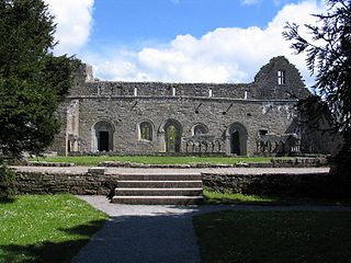
Cong Abbey also known as the Royal Abbey of Cong, is a historic site located at Cong, County Mayo, in Ireland's province of Connacht. The ruins of the former Augustinian abbey mostly date to the 13th century and have been described as featuring some of finest examples of medieval ecclesiastical architecture in Ireland.

<span class="mw-page-title-main">Loch Na Fooey</span> Glacial lake in County Galway

Loch Na Fooey, also Loch Nafooey or Lough Nafooey, is a rectangular shaped glacial lake in County Galway, Ireland. Part of the north-eastern shore lies along the border to County Mayo. The closest village is Finny, County Mayo with the County Galway village of Leenaun approximately 11 km distant.

<span class="mw-page-title-main">Cong Canal</span> Canal in Ireland

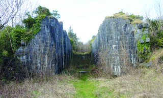
The Cong Canal is a derelict canal in the village of Cong, County Mayo. Ireland. It was abandoned unfinished in 1854 and is popularly known as 'The Dry Canal'.

<span class="mw-page-title-main">Cregg River</span> River in Ireland

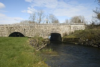
The Cregg River is a river in County Galway, Ireland. The river rises from a spring a half mile to the north of Cregg Mill, and flows for about seven miles into Lough Corrib. The upper stretch of the river is a nursery for fish stocking of Lough Corrib, while salmon and brown trout fishing is permitted on the lower stretches.

<span class="mw-page-title-main">Ballynahinch Lake</span> Lake in Galway, Ireland

Ballynahinch Lake is a freshwater lake in the west of Ireland. It is located in the Connemara area of County Galway.

References

  1. "Príommhbhord lascaigh agus Boird lascaigh Réigiúnacha Tuarascaíl Bhliantúil Dhieridh" [Central Fisheries Board and Regional Fisheries Boards Derry Annual Report] (in Irish). Archived from the original on 24 September 2016. Retrieved 3 March 2020.
  2. Ordnance Survey, The Complete Road Atlas of Ireland:Published in 1997 by Ordnance Survey of Ireland. Map page 31, ISBN   1-901496-81-3
  3. Drew, D. P. and Daly, D., Groundwater and Karstification in Mid-Galway, South Mayo and North Clare, Geological Survey of Ireland, Report Series 93/3, Dublin, 1993.
  4. 1 2 "Lough Corrib, Lough Mask and Cong". Mayo, Ireland. Retrieved 1 March 2020.
  5. "Lough Corrib and its tributaries". Angling Ireland. Retrieved 1 March 2020.
  6. Wilde, William (1872). Lough Corrib, Its Shores and Islands: with notices of Lough Mask. McGlashan & Gill, Dublin. p. 161.