
Douglas is the capital city and largest settlement of the Isle of Man, with a population of 26,677 (2021) and an area of 4.1 square miles (10.5 km2). It is located at the mouth of the River Douglas, and on a sweeping bay of two miles. The River Douglas forms part of the city's harbour and main commercial port.

Michael is one of the six sheadings of the Isle of Man. It is located on the west of the island and consists of the three historic parishes of Ballaugh, Jurby and Michael.

Marown is one of the seventeen historic parishes of the Isle of Man. It is the only landlocked parish on the Island.
River Glass may refer to:

The River Glass is a river on the Isle of Man. The river begins in the area of Injebreck about 10km north of Douglas, the Island's capital. Flowing down through the West Baldwin Valley, the river joins the River Dhoo to form the River Douglas on the outskirts of Douglas before flowing out to sea. The river has a length of approximately 8.5km.

The River Dhoo is a river on the Isle of Man. The river rises in Marown and flows east towards Douglas through the central valley of the island, passing Crosby and Union Mills before meeting with the River Glass on the outskirts of Douglas where it flows out to sea through Douglas Harbour. The Dhoo and the Glass converge to form the River Douglas. It has a length of approx. 6.5 mi (10.5 km).
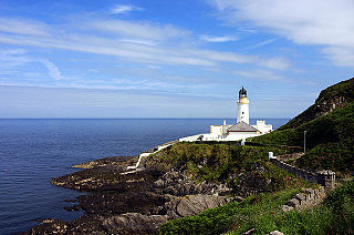
Douglas Head Lighthouse is a lighthouse at Douglas Head on the Isle of Man located between England and Ireland.
Union Mills is a village in the parish of Braddan on the A1, the primary road which connects Douglas and Peel in the Isle of Man, close to the River Dhoo.
The Moddey Dhoo is a phantom black dog in Manx folklore that reputedly haunted Peel Castle on the west coast of the Isle of Man. The Manx name Moddey Dhoo was transcribed as Mauthe Doog by an influential 18th-Century English-speaking folklore source, which led to a history of misspellings of the proper name.

Braddan Bridge is a bridge over the river Dhoo on the Douglas to Peel road, from which a halt on the Isle of Man Railway's first line to Peel took its name.

Union Mills Railway Station was an intermediate stop on the Isle of Man Railway; it served the village of Union Mills in the Isle of Man and was a stopping place on a line that ran between Douglas and Peel. It was part of the island's first railway line and the first official stopping place.
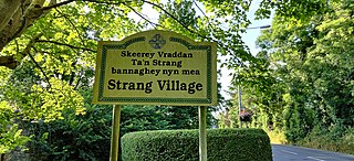
Strang or The Strang is a settlement within the parish of Braddan on the Isle of Man. It is almost contiguous with Douglas, the largest town on the island, and with the village of Union Mills. Nearby is Noble's Hospital, the island's only general hospital, sited on land which was originally purchased for an asylum in 1862, with completion in 1868, known as Ballamona Hospital.
Quarterbridge Crossing was the first major crossing point of the Isle of Man Railway's first line from Douglas to Peel. It opened in 1873, but closed in 1968, with the rest of the line.
Crosby is a small village located 3+3⁄4 miles west of Douglas in the parish of Marown in the Isle of Man.
The Greeba River is a river in the Isle of Man.

Onchan, historically Kirk Conchan, is one of the seventeen historic parishes of the Isle of Man.

Greeba Bridge is situated between the 6th milestone and 7th road milestones on the primary A1 Douglas to Peel road and the junction with the Greeba Mill Road in the parish of Kirk German in the Isle of Man.

Quarterbridge is situated soon after the 1 mile-marker measured from the TT Grandstand, part of the Snaefell Mountain Course used for the Isle of Man TT races, at the junction of the primary A1 Douglas to Peel road, A2 Douglas to Ramsey road and the A5 Douglas to Port Erin road which forms the boundary between the parishes of Braddan and Onchan in the Isle of Man.
Juan Noa was the pen-name of John Henry Cleator, a Manx dialect poet and playwright active from the 1920s to the 1960s in the Isle of Man.

