
Back of Keppoch is a small coastal settlement in the northwest Scottish Highlands, 40 miles west of Fort William near to the A830 road to Mallaig.
The A82 is a major road in Scotland that runs from Glasgow to Inverness via Fort William. It is one of the principal north-south routes in Scotland and is mostly a trunk road managed by Transport Scotland, who view it as an important link from the Central Belt to the Scottish Highlands and beyond. The road passes close to numerous landmarks, including; Loch Lomond, Rannoch Moor, Glen Coe, the Ballachulish Bridge, Ben Nevis, the Commando Memorial, Loch Ness, and Urquhart Castle.
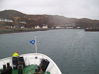
Mallaig is a port in Lochaber, on the west coast of the Highlands of Scotland. The local railway station, Mallaig, is the terminus of the West Highland railway line and the town is linked to Fort William by the A830 road – the "Road to the Isles".

The A87 is a major road in the Highland region of Scotland.

The A830, also known as the Road to the Isles is a major road in Lochaber, Scottish Highlands. It connects the town of Fort William to the port of Mallaig.
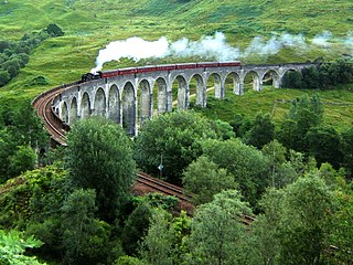
The Glenfinnan Viaduct is a railway viaduct on the West Highland Line in Glenfinnan, Inverness-shire, Scotland, built from 1897 to 1901. Located at the top of Loch Shiel in the West Scottish Highlands, the viaduct overlooks the Glenfinnan Monument and the waters of Loch Shiel.

Loch Shiel is a freshwater loch situated 20 kilometres (12 mi) west of Fort William in the Highland council area of Scotland. At 28 kilometres long it is the 4th longest loch in Scotland, and is the longest to have retained a natural outflow without any regulation of its water level, being 120 m (393 ft) deep. Its nature changes considerably along its length, being deep and enclosed by mountains in the north east and shallow surrounded by bog and rough pasture in the south west, from which end the 4 km River Shiel drains to the sea in Loch Moidart near Castle Tioram.

Corran is a hamlet on the northern shore of Loch Hourn, in Lochalsh in Inverness-shire in the Highlands of Scotland. It is situated at the foot of Glen Arnisdale, where the River Arnisdale flows past into Loch Hourn.

Tomdoun is a settlement on the north side of the River Garry, near the western end of Loch Garry, in Glen Garry in the Highlands of Scotland. The name comes from the Gaelic for "the brown hillock".

Kintail is an area of mountains in the Northwest Highlands of Scotland, located in the Highland Council area. It consists of the mountains to the north of Glen Shiel and the A87 road between the heads of Loch Duich and Loch Cluanie; its boundaries, other than Glen Shiel, are generally taken to be the valleys of Strath Croe and Gleann Gaorsaic to the north and An Caorann Mòr to the east. Although close to the west coast the mountains lie on the main east–west watershed of Scotland, as the northern side of Kintail drains via Glen Affric to the east coast.

Sgùrr a' Bhealaich Dheirg is a Scottish mountain situated in Kintail on the northern side of Glen Shiel, 30 kilometres south east of Kyle of Lochalsh.
Eilean Shona is a tidal island in Loch Moidart, Scotland. The modern name may be from the Old Norse for "sea island". The pre-Norse Gaelic name, as recorded by Adomnán was Airthrago or Arthràigh, meaning 'foreshore island', similar to the derivation of Erraid.

Ardmolich and Kinlochmoidart are settlements at the east head of Loch Moidart in the Moidart region, Highland, Scotland and are in the Scottish council area of Highland.

Garbh Uisge is a river of approximately 7 km in the Trossachs of Scotland just north-west Callander. It is the outflow of Loch Lubnaig and joins with Eas Gobhain west of Callander to form the River Teith. The name of the river, Garbh Uisge, is Gaelic for "Rough Water", reflecting the nature of the river. The river is often informally called the River Leny due to the Falls of Leny, where the river crosses the Highland Boundary Fault, and because it flows through the Pass of Leny.

Sgùrr Ghiubhsachain is a mountain in the Lochaber area in the west of Scotland. Its summit is the highest point in a group of mountains that stand south of Glenfinnan, to the south east of the northern part of Loch Shiel. It is considerably lower than the nearby Nevis range, but it is a long way from a public road. Its slopes are steep and rugged on all sides and are devoid of paths. Despite easy access to the trail head from the road from Fort William to Mallaig, an individual or party that climbs this mountain may be alone there, even on a fine day in the summer.

Sgùrr Thuilm is a mountain in the Glenfinnan area of the Highlands of Scotland. It stands at the head of Glen Finnan approximately 7 kilometres (4 mi) north of Loch Shiel.

The River Garry is a major tributary of the River Tummel, itself a tributary of the River Tay, in the traditional county of Perthshire in the Scottish Highlands. It emerges from the northeastern end of Loch Garry (56.8193°N 4.2311°W), just to the southeast of the Pass of Drumochter, and flows southeastwards and eastwards down Glen Garry to the narrow Pass of Killiecrankie beyond which it joins the Tummel (56.7182°N 3.7790°W).

The River Awe is a short river in the Southwest Highlands of Scotland by which the freshwater Loch Awe empties into Loch Etive, a sea loch. The river flows from a barrage which stretches across the end of a deep arm of the loch which protrudes northwestward through the Pass of Brander from the northeast–southwest aligned Loch Awe. The river is accompanied for much of its length both by the railway from Glasgow to Oban and by the A85 road both of which cross the river halfway along its length. The Awe is also crossed by a minor road bridge and a foot bridge.

Gleann Dubh Lighe is a glen (valley) in Lochaber, Highland, Scotland, located at the foot of Streap in the Northwest Highlands mountain range. The Dubh Lighe river flows through the length of the valley. A frequented spot for hiking, the valley is known for the eponymous bothy located in the valley which is maintained by the Mountain Bothies Association (MBA). It accidentally burned down in late 2011, but was rebuilt in June 2013 by volunteers of the MBA.
Glen Finnan is a glen (valley) in Lochaber, Highland, Scotland, located at the foot of Streap in the Northwest Highlands mountain range. The River Finnan, which flows into Loch Shiel, flows the entire length of the valley. The Sgùrr Thuilm mountain stands at the head of Glen Finnan.
