
Dyfed is a preserved county in southwestern Wales. It is a mostly rural area with a coastline on the Irish Sea and the Bristol Channel.

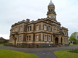
Carmarthenshire is a county in the south-west of Wales. The three largest towns are Llanelli, Carmarthen and Ammanford. Carmarthen is the county town and administrative centre. The county is known as the "Garden of Wales" and is also home to the National Botanic Garden of Wales.
Llanelli is a market town and community in Carmarthenshire and the preserved county of Dyfed, Wales. It is located on the Loughor estuary and is also the largest town in the county of Carmarthenshire.

Burry Port is a port town and community in Carmarthenshire, Wales, on the Loughor estuary, to the west of Llanelli and south-east of Kidwelly. Its population was recorded at 5,680 in the 2001 census and 6,156 in the 2011 census, and estimated at 5,998 in 2019. The town has a harbour. It is also where Amelia Earhart landed as the first woman to fly across the Atlantic Ocean. Nearby are the Pembrey Burrows sand dune and wetland system, forming a country park, and the Cefn Sidan sands. Its musical heritage includes Burry Port Opera, Male Choir and Burry Port Town Band.

Carmarthen Bay is an inlet of the South Wales coast, including notable beaches such as Pendine Sands and Cefn Sidan sands. Carmarthen Bay is partially within the Pembrokeshire Coast National Park. The Joint Nature Conservation Committee list Carmarthen Bay and Estuaries as a Special Area of Conservation.

Llanelli is a constituency of the House of Commons of the Parliament of the United Kingdom. From 1918 to 1970 the official spelling of the constituency name was Llanelly. It elects one Member of Parliament (MP) by the first past the post system of election. Since 2005, it is currently represented by Nia Griffith of the Labour Party.

Felinfoel is a small village and electoral ward on the River Lliedi on the northern border of Llanelli, Carmarthenshire, West Wales, with a population of about 2,000.

The River Gwendraeth is a river in Carmarthenshire in West Wales.
The Amman Valley Railway Society is situated near the former Gwaun Cae Gurwen branch line, that runs alongside the River Amman, some 10 miles (16 km) north of Swansea in west Wales. Its primary focus is to construct Swansea 9 Lines, an eco-friendly tram system to the heart of Swansea and the surrounding areas. The project was originally based on a heritage railway proposal on a lines that formerly served the various collieries of the area north of Swansea and Llanelli.
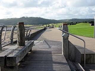
The Millennium Coastal Park was originally a project undertaken by Llanelli Borough Council to transform a 12 miles stretch of industrial wasteland on the south Carmarthenshire coast into green parkland. The project was then taken over by Carmarthenshire County Council after the amalgamation of Welsh local authorities and the land was transformed into a landscaped recreational area for the general public. The park is 1000 hectares in area, cost £35 million to develop and in 2002 was awarded a Civic Trust Award. It has extensive views over the Lloughor Estuary to the Gower Peninsula. It includes a cycle track which provides traffic-free cycling and has been described as "one of the finest stretches of the whole National Cycle Network". Another feature is a wave-shaped, grass-covered landform, created from 115,000 cubic metres (4,100,000 cu ft) pulverised fuel ash, a form of "land art".
Coleg Sir Gâr is a further education college in Carmarthenshire, Wales, with five campuses across the county.
North Dock is a former industrial dock in Llanelli, West Wales used mainly for exporting coal and tin plate from South Wales. It is also the name of the area immediately surrounding the dock. Llanelli Beach is also known locally as North Dock.
The Llanelly and Mynydd Mawr Railway was authorised in 1875. It made use of part of the long defunct Carmarthenshire Railway or Tramroad of 1801. The older line began running trains in 1803, and was a plateway of about 4 ft gauge, with horse traction, for the purpose of bringing minerals from the Mynydd Mawr to the sea for onward shipment at Llanelly Docks.
Horeb is a hamlet in Carmarthenshire, Wales, near the town of Llanelli. It is situated east of the village of Five Roads about five miles from Llanelli. The hamlet has one pub, the Waun Wyllt. It is situated in the River Lliedi valley, in which the river bearing the same name flows. Welsh is the dominant language.

Burry Port Lighthouse is a lighthouse in Burry Port.

Saint Elli was a 6th-century Welsh saint, or possibly two saints. Llanelli in Carmarthenshire and Llanelly in Monmouthshire are both named after Elli.
Crown Park Suburbs are a Welsh football club from Llanelli in Carmarthenshire. They have played in the Welsh Football League reaching the top flight, Division One. They last played in the Carmarthenshire League.
Lloyd Street, Llanelli was an Independent (Congregationalist) chapel in Lloyd Street, Llanelli, Carmarthenshire. Services at Lloyd Street were conducted in the Welsh language.
Lliedi is an electoral ward for Llanelli Town Council and Carmarthenshire County Council in Llanelli, Wales.
Elli is an electoral ward for Llanelli Town Council and Carmarthenshire County Council in Llanelli, Wales.
