
The Tamar is a river in south west England, that forms most of the border between Devon and Cornwall. A part of the Tamar valley is a World Heritage Site due to its historic mining activities.

The River Dee, in south-west Scotland, flows from its source in Loch Dee amongst the Galloway Hills, firstly to Clatteringshaws Loch, then into Loch Ken, where it joins the Water of Ken. From there, the Dee flows 15 miles (24 km) southwards to Kirkcudbright, and into Kirkcudbright Bay to reach the Solway Firth. The distance is just over 38 miles (61 km) in total. Together with its tributaries, the Dee's total catchment area is over 400 square miles (1,000 km2).

Mid Devon is a local government district in Devon, England. Its council is based in Tiverton.
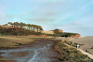
The River Otter rises in the Blackdown Hills just inside the county of Somerset, England near Otterford, then flows south through East Devon. It enters the English Channel at the western end of Lyme Bay, part of the Jurassic Coast, a UNESCO World Heritage Site. The Permian and Triassic sandstone aquifer in the Otter Valley is one of Devon's largest groundwater sources, supplying drinking water to 200,000 people.

The River Devon is a tributary of the River Trent, which rises in Leicestershire and joins the Trent at Newark in Nottinghamshire, England. In its upper reaches, it supplies Knipton Reservoir, which was built to supply water to the Grantham Canal, and Belvoir Lakes, designed by Capability Brown. It passes under the Grantham Canal, and then through Bottesford, where it is spanned by five railway bridges, only one of which is still used for its original purpose. On the outskirts of Newark, it passes by two Civil War structures, and just before it joins the Trent it becomes navigable, with a marina located on the west bank. Its name is pronounced "Deevon", not as spelt.

The River Taw rises at Taw Head, a spring on the central northern flanks of Dartmoor, crosses north Devon and close to the sea at the town of Barnstaple, formerly a significant port, empties into Bideford Bay in the Bristol Channel having formed a large estuary of wide meanders which at its western extreme is joined by the estuary of the Torridge.

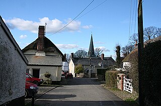
Zeal Monachorum is a village and civil parish in the Mid Devon district of Devon, England, about 18 miles (29 km) north-west of Exeter, situated on the River Yeo. According to the 2001 census it had a population of 398. The village is in the electoral ward of Taw whose population at the 2011 Census was 1.660.

The River Torridge is a river in Devon in England. The River Torridge rises near Meddon. The river describes a long loop through Devon farming country where its tributaries the Lew and Okement join before meeting the Taw at Appledore and flowing into the Bristol Channel. The river is spate dependent and often flows between wooded banks which can be steep. The Torridge local government district is named after the river.
The River Creedy is a small river in Devon, England. It gives its name to the local town or ton of Crediton, which is on its west bank, and to several local historic estates, namely Creedy Hilion, Creedy Peitevin and Creedy Park, in the parish of Sandford, also to the Benefice of North Creedy. Just below the town, the river merges with the River Yeo and it ends where it meets the River Exe at Cowley Bridge. The river is overlooked by Fordy Wood Copse, a 0.64 hectares woodland owned and managed by the Woodland Trust.
The River Bovey rises on the eastern side of Dartmoor in Devon, England, and is the largest tributary to the River Teign. The river has two main source streams, both rising within a mile of each other, either side of the B3212 road between Moretonhampstead and Postbridge, before joining at Jurston.

The River Lemon is a 9.9 mile river in the county of Devon in southwest England. It is a tributary of the River Teign, starting on Dartmoor by Haytor, and ending in Newton Abbot. It rises on the south-east side of Dartmoor near Haytor, joins with the River Sig and the Langworthy Brook at Sigford, then passes the village of Bickington. Lower down, it is joined by the Kestor Brook and it then flows through the woods in Bradley Valley, past the manor house of Bradley, and through the town of Newton Abbot where it flows through a 440-yard-long tunnel below the town centre. Just below the town, the river joins the River Teign at 50.517°N 3.607°W, near the head of its estuary.
Nymet Rowland is a small village, and parish of the same name, in central Devon, England, north of Dartmoor. It takes part of its name from "Nymet", the old name for the nearby River Yeo. It is located just to the west of Lapford and south of Nymet Bridge, within the Mid Devon local authority area. Historically it formed part of Winkleigh Hundred; today the North Tawton hundred. It falls within the Cadbury Deanery for ecclesiastical purposes.

The River Yeo is a tributary of the River Taw in Devon, England, sometimes known as the Barnstaple Yeo, which enters the Taw at Barnstaple. It is one of several rivers of the same name in Devon, including another tributary of the Taw, the Lapford Yeo.

The Little Dart River is a tributary of the River Taw in Devon, England. It joins the Taw a mile west of Chulmleigh.

The River Ottery is a small river in northeast Cornwall, United Kingdom. The river is about twenty miles (32 km) long from its source southeast of Otterham to its confluence with the River Tamar at Nether Bridge, two miles (3.2 km) northeast of Launceston.

Bideford Bay, also known as Barnstaple Bay and often shown on maps as Barnstaple or Bideford Bay, is a large area of water on the northwest coast of Devon in South West England, at the southwestern end of the Bristol Channel where it joins the Celtic Sea. The bay extends from Hartland Point in the southwest to Baggy point the northeast, and is partly sheltered by the island of Lundy, 12 miles (19 km) offshore. It takes its alternative names from the towns of Bideford and Barnstaple, located respectively on the rivers Torridge and Taw which flow into the bay. The alternative spelling Barnstable Bay, in use long after that spelling became obsolete for the town, is also sometimes seen.
King's Nympton is a village, parish and former manor in North Devon, England in the heart of the rolling countryside between Exmoor and Dartmoor, some 4½ miles (7 km) S.S.W. of South Molton and 4 miles (6 km) N. of Chulmleigh. The parish exceeds 5,500 acres (2,226 ha) in area and sits mostly on a promontory above the River Mole which forms nearly half of its parish boundary.

The River Yeo is a tributary to the River Creedy. It is located in Devon, England, and its headwaters float within two miles of a different River Yeo, which is a tributary to River Taw.

The River Bray is a small river in North Devon, England. It is a tributary of the River Mole, which in turn is a tributary of the River Taw. It rises in Exmoor, near the border with Somerset.
The River Smite, a tributary of the River Devon, flows for 20 miles (32 km) through Leicestershire and south-east Nottinghamshire, England. The source is near the hamlet of Holwell, Leicestershire and it joins the Devon near Shelton, Nottinghamshire. The Smite and its tributaries, such as the River Whipling, the Stroom Dyke, and the Dalby Brook, drain an area of 193 square kilometres (75 sq mi) of farmland in the Vale of Belvoir.
