Riverdale Road Covered Bridge

Last updated
Riverdale Road Bridge
Riverdale Road (Ashtabula County, Ohio) Covered Bridge 1.jpg
Coordinates 41°40′24″N80°52′19″W / 41.67333°N 80.87194°W / 41.67333; -80.87194
LocaleAshtabula County, Ohio, United States
Characteristics
Designsingle span, Town truss
Total length140 feet (42.7 m)
History
Construction start1874
Location
Riverdale Road Covered Bridge

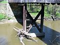
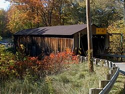
Riverdale Road Bridge is a covered bridge spanning the Grand River in Morgan Township, Ashtabula County, Ohio, United States. The bridge, one of currently 16 drivable bridges in Ashtabula county, is a single span Town truss design. During its renovation in 1981, the floor was rebuilt and glue-laminated wood girders were added. Previously, center steel bracing had been replaced under the bridge in 1945. In 1987, a new concrete abutment for additional support was added after the road at the east end of the bridge washed out. [1] The bridge’s WGCB number is 35-04-22, [2] and it is located approximately 1.1 mi (1.8 km) north-northwest of Rock Creek.

Contents

History

Dimensions

See also

Related Research Articles

<span class="mw-page-title-main">Benetka Road Covered Bridge</span> Bridge in Ohio, United States

Benetka Road Bridge is a covered bridge spanning the Ashtabula River in Ashtabula County, Ohio, United States. The bridge, one of currently 17 drivable bridges in the county, is a single span Town truss design, with laminated arches being added during its renovation in 1985. The bridge’s WGCB number is 35-04-12, and it is located approximately 4 mi (6.4 km) south of North Kingsville.

<span class="mw-page-title-main">Caine Road Covered Bridge</span> Bridge in Ohio, United States

Caine Road Bridge is a covered bridge spanning the west branch of the Ashtabula River in Pierpont Township, Ashtabula County, Ohio, United States. The bridge, built in honor of Ashtabula County's 175th anniversary, and one of currently 17 drivable bridges in the county, is a single span Pratt truss design. The bridge's WGCB number is 35-04-61, and it is located approximately 13 mi (21 km) east-northeast of Jefferson.

<span class="mw-page-title-main">Creek Road Covered Bridge</span> Covered bridge

Creek Road Bridge is a covered bridge spanning Conneaut Creek in Conneaut, Ashtabula County, Ohio, United States. The single span Town truss bridge is one of 16 bridges currently open to vehicle traffic in the county. The bridge's WGCB number is 35-04-12, and it is located approximately 3.4 mi (5.5 km) southwest of Conneaut.

<span class="mw-page-title-main">Doyle Road Covered Bridge</span> Bridge in Ohio, United States

Doyle Road Bridge is a covered bridge spanning Mill Creek in Jefferson Township, Ashtabula County, Ohio, United States. The bridge, one of 16 drivable bridges in the county, is a single span Town truss design, with laminated arches added during its renovation in 1987. The bridge’s WGCB number is 35-04-16, and it is located approximately 1.9 mi (3.1 km) north-northwest of Jefferson.

<span class="mw-page-title-main">Giddings Road Covered Bridge</span> Bridge in northeast Ohio, USA

Giddings Road Bridge is a covered bridge spanning Mill Creek in Jefferson Township, Ashtabula County, Ohio, United States. The bridge, one of currently 16 drivable bridges in the county, is a single span Pratt truss design, built with funding from an ODOT Timber Grant. The bridge’s WGCB number is 35-04-62, and it is located approximately 2.7 mi (4.3 km) northeast of Jefferson.

<span class="mw-page-title-main">Harpersfield Covered Bridge</span> Covered bridge in Ohio, United States

Harpersfield Bridge is a covered bridge spanning the Grand River in Harpersfield Township, Ashtabula County, Ohio, United States. * Currently disassembled for renovation 2023 * This double-span Howe truss bridge, one of currently 17 drivable covered bridges in the county, is the third longest covered bridge in Ohio at 228 feet. A flood in 1913 washed away the land at the north end of the bridge, and the steel span was subsequently attached. The bridge features a walkway, added during its renovation in 1991–1992. The bridge also features an Ashtabula County MetroPark at its north end and is listed on the National Register of Historic Places. The bridge's WGCB number is 35-04-19, and it is located approximately 3.4 miles south of Geneva.

<span class="mw-page-title-main">Graham Road Covered Bridge</span> Bridge in Ohio, United States

Graham Road Bridge is a covered bridge which formerly spanned the west branch of the Ashtabula River in Pierpont Township, Ashtabula County, Ohio, United States. Built from remnants of a former covered bridge that was damaged in a flood in 1913, the bridge now sits in an Ashtabula County MetroPark along the south side of Graham Road, near its original site, and is a single span Town truss design. Relocated in 1972, it is no longer open to vehicle traffic. The bridge’s WGCB number is 35-04-13, and it is located approximately 8.4 mi (13.5 km) east-northeast of Jefferson.

<span class="mw-page-title-main">Mechanicsville Road Covered Bridge</span> Bridge in Ohio, United States

Mechanicsville Road Bridge is a covered bridge spanning the Grand River in Austinburg Township, Ashtabula County, Ohio, United States. The bridge, one of currently 17 drivable bridges in the county, is the longest single span covered bridge in the county, and is believed to be the oldest in the county as well. The bridge is a Howe truss design, with laminated arches added during its renovation in 2003-04. The bridge’s WGCB number is 35-04-18, and it is located approximately 4.3 mi (7.0 km) southeast of Geneva.

<span class="mw-page-title-main">Middle Road Covered Bridge</span> Bridge in Ohio, United States

Middle Road Bridge is a covered bridge spanning Conneaut Creek in Conneaut, Ashtabula County, Ohio, United States. The bridge, one of currently 16 drivable bridges in the county, is a single span Howe truss design. Built in 1868, it was reconstructed in 1984 with the help of three volunteers and four college students. The bridge’s WGCB number is 35-04-06, and it is located approximately 3.2 mi (5.1 km) south of downtown Conneaut. It is 136 feet long.

<span class="mw-page-title-main">Netcher Road Covered Bridge</span> Bridge in Ohio, United States

Netcher Road Bridge is a covered bridge spanning water in Jefferson Township, Ashtabula County, Ohio, United States. The bridge, one of the newest and one of currently 17 drivable covered bridges in the county, is a single span constructed of timber arches with inverted Haupt walls, in a "Neo-Victorian" design. It was built in 1998, and it was funded by an ODOT Timber Grant. The bridge’s WGCB number is 35-04-63, and it is located approximately 2.0 mi (3.2 km) east of Jefferson.

<span class="mw-page-title-main">Olin's Covered Bridge</span> Bridge in Ohio, United States

Olin's Bridge, or Olin Bridge, or Olin-Dewey Road Bridge is a covered bridge that carries Dewey Road over the Ashtabula River in Plymouth Township, Ashtabula County, Ohio, United States. The bridge, one of currently 16 drivable bridges in the county, is a single span Town truss design, and is currently the only bridge in the county named for a family. The Olin family has owned property next to the bridge since it was built. Members of the Olin family also operate a small museum and gift shop just east of the bridge at the house previously owned by Joyce Grandbouche. The bridge’s WGCB number is 35-04-03, and it is located approximately 3.6 mi (5.7 km) east of Ashtabula.

<span class="mw-page-title-main">Root Road Covered Bridge</span> Bridge in Ashtabula County, Ohio, United States

Root Road Bridge is a covered bridge spanning the west branch of the Ashtabula River in Monroe Township, Ashtabula County, Ohio, United States. The bridge, one of currently 16 drivable bridges in the county, is a single span Town truss design. During its renovation in 1982-83, the bridge was raised 18 inches (460 mm), and a new center pier was added. The bridge’s WGCB number is 35-04-09, and it is located approximately 6.3 mi (10.1 km) southeast of North Kingsville.

<span class="mw-page-title-main">South Denmark Road Covered Bridge</span> Bridge in Ohio, United States

South Denmark Road Bridge is a covered bridge spanning Mill Creek in Denmark Township, Ashtabula County, Ohio, United States. The bridge, one of currently 16 drivable bridges in the county, is a single span Town truss design. Bypassed in 1975, the bridge still remains open to light traffic. The bridge’s WGCB number is 35-04-14, and it is located approximately 4.4 mi (7.1 km) east-southeast of Jefferson.

<span class="mw-page-title-main">State Road Covered Bridge</span> Bridge in Ohio, United States

State Road Bridge is a covered bridge spanning Conneaut Creek in Monroe Township, Ashtabula County, Ohio, United States. The bridge, one of currently 17 drivable bridges in the county, is a single span Town truss design. Constructed of 97,000 feet (30,000 m) of southern pine and oak, it features a 4-foot-tall (1.2 m) window which extends the length of the bridge. The dedication of the bridge in 1983 was the forerunner of the Ashtabula County Covered Bridge Festival. The bridge’s WGCB number is 35-04-58, and it is located approximately 3.9 miles (6.3 km) east-southeast of North Kingsville.

<span class="mw-page-title-main">Windsor Mills Covered Bridge</span> United States historic place

Windsor Mills Bridge, also known as Wiswell Road Bridge or Warner Hollow Road Bridge, is a covered bridge that carries Covered Bridge Lane, formerly Wiswell Road, across Phelps Creek in Windsor Township, Ashtabula County, Ohio, United States. The bridge, one of currently 17 drivable bridges in the county, is a single-span Town truss design. The bridge was built in 1867 using white pine. It sits atop cut stone abutments, one made of sandstone quarried nearby, and the other made of creek stone. The bridge was bypassed in the 1960s and closed to traffic, and Wiswell Road was rerouted west of the creek. In the 1980s, the bridge was completely closed due to safety reasons. It underwent extensive renovation from 2002 to 2004, and was then reopened to all traffic, except for trucks and buses. The bridge is listed in the National Register of Historic Places. The bridge's WGCB number is 35-04-25, and it is located approximately 5.0 mi (8.0 km) west of Orwell.

<span class="mw-page-title-main">Smolen–Gulf Bridge</span> Covered bridge in Ohio, United States

The Smolen–Gulf Bridge is a covered bridge which carries State Road across the Ashtabula River at the Plymouth and Ashtabula Township line in northern Ashtabula County, Ohio, United States. At 613 feet, it is the longest covered bridge in the United States – a title formerly held by the Cornish–Windsor Covered Bridge in New Hampshire – and the fourth longest covered bridge in the world. The bridge, one of 17 drivable covered bridges in the county, was designed by John Smolen, former Ashtabula County Engineer when the idea of bridging the Ashtabula River Gulf with a wooden structure was first conceived in 1995.

<span class="mw-page-title-main">Whittier Bridge</span> United States historic place

The Whittier Bridge is a historic wooden covered bridge in Ossipee, New Hampshire. The bridge carried an old alignment of New Hampshire Route 25 over the Bearcamp River. Built in 1870, it is one of New Hampshire's few surviving 19th-century covered bridges, and a rare example of a Paddleford truss. The bridge was listed on the National Register of Historic Places in 1984. It was closed to vehicular traffic in 1989, and was removed from its footings for restoration in 2008. As of September 2019, the bridge is resting on Nudd Road adjacent to the crossing point. It was placed back on its abutments in the late fall of 2022.

<span class="mw-page-title-main">Clinton Falls Bridge</span> Bridge in Minnesota, US

The Clinton Falls Bridge, also known as the Old Mill Bridge and formally as Bridge L-5573, is a historic steel Pratt through truss bridge that spans the Straight River in Clinton Falls Township, Minnesota. It was listed on the National Register of Historic Places in 1997 as Bridge No. L-5573 for having local significance in the theme of engineering. It was nominated for being an example of early steel truss bridge design in Minnesota.

<span class="mw-page-title-main">Meems Bottom Covered Bridge</span> United States historic place

Meems Bottom Covered Bridge is a covered bridge in Shenandoah County, Virginia, United States. The bridge, at 204 feet (62 m), is the longest covered bridge in Virginia and one of the last that supports regular traffic. Near the town of Mount Jackson, the Meems Bottom Covered Bridge features a 200-foot single-span wooden Burr arch structure. Built in 1892 by Franklin Hiser Wissler, the wooden bridge over the North Fork of the Shenandoah River provided access to his apple orchards at Strathmore Farms. The bridge was listed on the National Register of Historic Places on June 10, 1975.

References

  1. 1 2 3 4 5 "Ashtabula County Ohio Covered Bridge Festival". Archived from the original on 2006-12-07. Retrieved 2006-11-20. Ashtabula County Ohio Covered Bridge Festival
  2. http://www.dalejtravis.com/bridge/ohio/htm/3500422.htm Ohio Covered Bridges List, 35-04-22