Riverview is a neighbourhood in Ottawa, Ontario, Canada. It is southeast of the downtown adjacent to the Rideau River, its location on which is its namesake. The 2021 Census population of Riverview is 13,113.

Rideau Street is a major street in downtown Ottawa, Ontario, Canada and one of Ottawa's oldest and most famous streets running from Wellington Street in the west to Montreal Road in the east where it connects to the Vanier district. Rideau Street is home to the Château Laurier, the CF Rideau Centre and the Government Conference Centre. Along with Wellington Street and Sussex Drive it was among the first streets in Ottawa to be host to businesses; it was created with the founding of the early town. The Plaza Bridge by the Rideau Canal is at its westmost point and the Cummings Bridge is at its eastmost point.
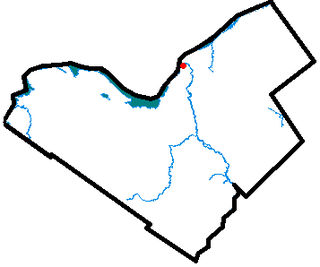
New Edinburgh is a neighbourhood in Rideau-Rockcliffe Ward, in Ottawa, Ontario, Canada. It is located to the northeast of the downtown core. It is bordered on the west by the Rideau River, to the north by the Ottawa River, to the south by Beechwood Avenue, and on the east by Springfield Road and the former Rockcliffe Park village limits.
Old Ottawa South is an older urban neighbourhood in Capital Ward in Ottawa, Ontario, Canada. Old Ottawa South is a relatively small and compact neighbourhood, located between the Rideau Canal and the Rideau River. The eastern boundary is Avenue Road. Bronson Avenue forms the western border of the residential neighbourhood. Carleton University is on the other (western) side of Bronson but the campus can be considered to be geographically within Old Ottawa South as the campus is also nestled between the river and the canal.

Ottawa—Vanier is a federal electoral district in Ontario, Canada, that has been represented in the House of Commons of Canada since 1935. Previous to that date, it was part of the Ottawa electoral district that returned two members.

The ByWard Market, is a retail and entertainment district in the downtown core of Ottawa, Ontario, Canada. It is located east of the government and business district. The Market district includes the market buildings and open-air market along George, York, ByWard, and William street.

Barrhaven is a rapidly growing suburban neighbourhood in the southwest of the urban area of the city of Ottawa, Ontario, Canada, about 17 km (11 mi) southwest of downtown Ottawa. Prior to amalgamation with Ottawa in 2001, Barrhaven was part of the City of Nepean. Its population as of the Canada 2021 Census was 103,234.

Downtown Ottawa is the central area of Ottawa, Ontario, Canada. It is sometimes referred to as the Central Business District and contains Ottawa's financial district. It is bordered by the Ottawa River to the north, the Rideau Canal to the east, Gloucester Street to the south and Bronson Avenue to the west. This area and the residential neighbourhood to the south are also known locally as 'Centretown'. The total population of the area is 4,876.

Old Ottawa East or just Ottawa East is a neighbourhood in Capital Ward in central Ottawa, Ontario, Canada. It is located south of Nicholas Street and between the Rideau Canal and the Rideau River, with Avenue Road marking the southern border. To the south is the neighbourhood of Old Ottawa South and to the northeast is Sandy Hill. Old Ottawa East includes the Lees Avenue area. The Flora Footbridge, which opened to pedestrians in 2019, connects the community to The Glebe.
Ottawa West was a federal and provincial electoral district in Ontario, Canada, that was represented in the House of Commons of Canada from 1935 to 1997 and in the Legislative Assembly of Ontario from 1908 to 1926 and from 1955 to 1999. It covered the western part of the Ottawa area.

Carleton is a federal electoral district in Ontario, Canada, represented in the House of Commons of Canada from 1867 to 1968 and since 2015. It was represented in the Legislative Assembly of Upper Canada from 1821 to 1840 and in the Legislative Assembly of the Province of Canada from 1841 until 1866.
Ottawa was a federal electoral district in the province of Ontario, Canada, that was represented in the House of Commons of Canada from 1867 to 1935.
Lower Town (also spelled "Lowertown" is a neighbourhood in Rideau-Vanier Ward in central Ottawa, Ontario, Canada, to the east of downtown. It is the oldest part of the city. It is bounded by Rideau Street to the south, the Ottawa River to the west and north and the Rideau River to the east. It includes the commercial Byward Market area in the south-western part, and is predominantly residential in the north and east.

Ottawa Centre is an urban provincial electoral district in Ontario, Canada that has been represented in the Legislative Assembly of Ontario since 1968. While the riding's boundaries have changed over the years to account for population changes, the riding has always comprised the central areas of Ottawa, the nation's capital.
Ottawa—Vanier is a provincial electoral district in Ottawa, Ontario, Canada, that has been represented in the Legislative Assembly of Ontario since 1908. It is located in the east end of Ottawa.
Wellington Ward was one of the original five wards of the city of Ottawa, Ontario, Canada created in 1855 from West Ward in Bytown, Upper Canada. It existed until 1994 when it was amalgamated with Dalhousie Ward to become Somerset Ward. The original ward consisted of the city west of the Rideau Canal and south of Wellington Street. It has traditionally consisted of Ottawa's Centretown and Downtown neighbourhoods. Prior to 1952, it consisted of the area between Bank Street and Bronson Avenue. In 1952, it merged with Central Ward, to its east, and lost some of its former territory to Dalhousie Ward on its west.
By Ward was one of the five original wards represented on Ottawa City Council, created in 1855 out of parts of East Ward and Centre Ward which existed in Bytown. Originally it represented the area between Rideau Street and St. Patrick Street. Today this area is part of the By Ward Market, which is named for the historic ward.
St. George's Ward was one of the original five wards of the city of Ottawa, Ontario, Canada created in 1855. out of parts of East Ward and Centre Ward, which existed in Bytown. It existed until 1972 when it merged with By Ward to become By-St. George's Ward. It was recreated in 1980, until it was abolished for a final time in 1994, when it merged with part of By-Rideau Ward to form Bruyère-Strathcona Ward.