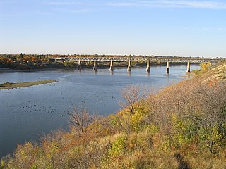
The Saskatchewan River is a major river in Canada, about 550 kilometres (340 mi) long, flowing roughly eastward across Saskatchewan and Manitoba to empty into Lake Winnipeg. Through its tributaries the North Saskatchewan and South Saskatchewan, its watershed encompasses much of the prairie regions of central Canada, stretching westward to the Rocky Mountains in Alberta and northwestern Montana in the United States. It reaches 1,939 kilometres (1,205 mi) to its farthest headwaters on the Bow River, a tributary of the South Saskatchewan in Alberta.

The Athabasca River originates from the Columbia Glacier of the Columbia Icefield in Jasper National Park in Alberta, Canada. The impressive and scenic Athabasca Falls is located upstream about 30 km (19 mi) from the Jasper townsite.

The Mackenzie River is the longest river system in Canada, and has the second largest drainage basin of any North American river after the Mississippi River. The Mackenzie River flows through a vast, thinly populated region of forest and tundra entirely within the Canadian Northwest Territories, although its many tributaries reach into four other Canadian provinces and territories.

Alberta is a Canadian province. Located in Western Canada, the province has an area of 661,190 square kilometres (255,290 sq mi) and is bounded to the south by the U.S. state of Montana along 49° north for 298 kilometres (185 mi); to the east at 110° west by the province of Saskatchewan for 1,223 kilometres (760 mi); and at 60° north the Northwest Territories for 644 kilometres (400 mi). The southern half of the province borders British Columbia along the Continental Divide of the Americas on the peaks of the Rocky Mountains, while the northern half borders British Columbia along the 120th meridian west.

Lake Athabasca is located in the northwest corner of Saskatchewan and the northeast corner of Alberta between 58° and 60° N. The lake is 26% in Alberta and 74% in Saskatchewan.

Wood Buffalo National Park is the largest National Park of Canada at 44,807 km2 (17,300 sq mi). It is located in northeastern Alberta and the southern Northwest Territories. Larger in area than Switzerland, it is the second-largest national park in the world. The park was established in 1922 to protect the world's largest herd of free roaming wood bison, currently estimated at more than 5,000. It is one of two known nesting sites of whooping cranes.
Peter Pond was a soldier with a Connecticut Regiment, a fur trader, a founding member of the North West Company and the Beaver Club, an explorer and a cartographer. Though he was born and died in Milford, Connecticut, most of his life was spent in northwestern North America.

The Peace River is a 1,923-kilometre-long (1,195 mi) river in Canada that originates in the Rocky Mountains of northern British Columbia and flows to the northeast through northern Alberta. The Peace River joins the Athabasca River in the Peace-Athabasca Delta to form the Slave River, a tributary of the Mackenzie River. The Finlay River, the main headwater of the Peace River, is regarded as the ultimate source of the Mackenzie River. The combined Finlay–Peace–Slave–Mackenzie river system is the 13th longest river system in the world.

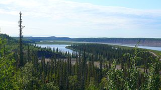
The Slave River is a Canadian river that flows from the confluence of the Rivière des Rochers and Peace River in northeastern Alberta and empties into Great Slave Lake in the Northwest Territories. The river's name is thought to derive from the name for the Slavey group of the Dene First Nations, Deh Gah Got'ine, in the Athabaskan language. The Chipewyan had displaced other native people from this region.

Lake Claire is the largest lake which is entirely in Alberta, Canada. It is located entirely in Wood Buffalo National Park, west of Lake Athabasca. It lies between the mouths of Peace River and Athabasca River, and is part of the Peace-Athabasca Delta system.

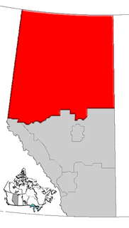
Northern Alberta is a region located in the Canadian province of Alberta.

The Fort McKay First Nation (FMFN) is a First Nations government in northeast Alberta comprising five Indian reserves – Fort McKay 174, Fort McKay 174C, Fort McKay 174D, Namur Lake 174B and Namur River 174A. The FMFN, signed to Treaty 8, is affiliated with the Athabasca Tribal Council and its members are of Cree, Metis and Dene heritage. The FMFN's traditional lands include portions of the Athabasca oil sands.

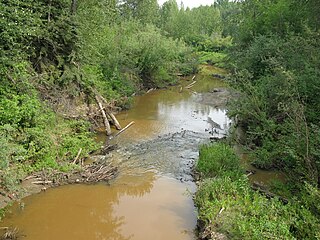
The Assineau River is a short river forming in central Alberta. The Assineau flows into Lesser Slave Lake, which flows out through the Lesser Slave River, a major tributary of the Athabasca River. The name for the river was in use by 1904. It is suggested that Assineau is a version of the Cree word for nobody.

The Driftpile River is a medium-length river forming in central Alberta. The Drifpile flows into Lesser Slave Lake, which flows out through the Lesser Slave River, a major tributary of the Athabasca River. The Geological Survey of Canada was using the name Driftpile by 1892. The river was named because of the large amount of driftwood that collected at the river's mouth.
See also Marten River, Ontario

The Peace River, which flows from the Rocky Mountains in British Columbia to the Peace–Athabasca Delta and Lake Athabasca in Alberta, was navigable by late nineteenth and early twentieth century steamboats from the Rocky Mountain Falls at Hudson's Hope to Fort Vermilion, where there was another set of rapids, then via the lower Peace from Vermilion to Lake Athabasca. The Peace is part of the Mackenzie Basin, a larger river complex which includes the Athabasca, Slave, and Mackenzie Rivers.

The Mackenzie River in Canada's Northwest Territories is a historic waterway, used for centuries by the original Dene as a travel and hunting corridor. It is part of a larger watershed that includes the Slave, Athabasca, and Peace rivers extending from northern Alberta. In the 1780s, Peter Pond, a trader with the North West Company discovered this watershed and began viable trade with the Athapascan-speaking Dene of these rivers. The Mackenzie River itself, the great waterway extending to the Arctic Ocean, was first put on European maps by Alexander Mackenzie in 1789, the Scottish trader who explored the river. The watershed thus became a vital part of the fur trade, and before the advent of the airplane or road networks, the river was the only communication link between northern trading posts and the south. Water travel increased in the late 19th century as traders, dominated primarily by the Hudson's Bay Company, looked to increase water services in the Mackenzie River District.

Kazan Wildland Park is a wildland provincial park in northern Alberta, Canada that is 570,955 ha in size. It is located in the far northeast corner of the province within the Regional Municipality of Wood Buffalo, encompassing the majority of lands north of Lake Athabasca and east of the Slave River and Rivière des Rochers adjacent to Wood Buffalo National Park. The Government of Alberta announced its creation through its approval of the Lower Athabasca Regional Plan in August 2012.


