
Seaford is a city located along the Nanticoke River in Sussex County, Delaware, United States. According to the 2010 Census Bureau figures, the population of the city is 6,928, an increase of 3.4% from the 2000 census. It is part of the Salisbury, Maryland-Delaware Metropolitan Statistical Area.

Vienna is a town in Dorchester County, Maryland, United States. The population was 271 at the 2010 census.

Nanticoke is a town in Broome County, New York, United States. The population was 1,672 at the 2010 census. The town was named after the Nanticoke people, who were a Native American tribe native to Chesapeake Bay.

Hanover Township is a township in Luzerne County, Pennsylvania. As of the 2020 census, the population was 11,424, making it the most populous township in the county.
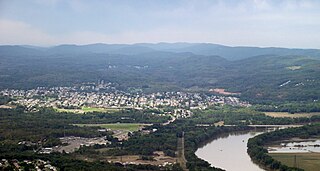
Nanticoke is a city in Luzerne County, Pennsylvania, United States. As of the 2020 census, the population was 10,628, making it the third largest city in Luzerne County. It occupies 3.5 square miles of land. Nanticoke is part of Northeastern Pennsylvania.

Newport Township is a township in Luzerne County, Pennsylvania, United States. As of 2020, the population was 4,444. Newport is located on the outskirts of Nanticoke City.
Haldimand County is a rural city-status single-tier municipality on the Niagara Peninsula in Southern Ontario, Canada, on the north shore of Lake Erie, and on the Grand River. Despite its name, it is no longer a county by definition, as all municipal services are handled by a single level of government. Municipal offices are located in Cayuga.
USS Nanticoke (AOG-66), was a type T1 Klickitat-class gasoline tanker built for the US Navy during World War II. She was named after the Nanticoke River, in Delaware and Maryland.
The Nanticoke people are a Native American Algonquian people, whose traditional homelands are in Chesapeake Bay and Delaware. Today they live in the Northeastern United States and Canada, especially Delaware; in Ontario; and in Oklahoma.

Pennsylvania Route 29 is a 118-mile-long (190 km) north–south state highway that runs through most of eastern Pennsylvania.

The Nanticoke Generating Station was a coal-fired power station in Nanticoke, Ontario in operation from 1972 to 2013. It was the largest coal power station in North America and, at full capacity, it could provide 3,964 MW of power into the southern Ontario power grid from its base in Nanticoke, Ontario, Canada, and provided as much as 15% of Ontario's electricity.
Nanticoke is an unincorporated community and former city located on the western border of Haldimand County, Ontario, Canada. Nanticoke is located directly across Lake Erie from the US city of Erie, Pennsylvania.

Bainbridge is an unincorporated community and census-designated place (CDP) in Conoy Township, Lancaster County, Pennsylvania, United States, with a ZIP code of 17502. Bainbridge is located along Pennsylvania Route 441. As of the 2010 census, the population was 1,355.

Piscataway is an extinct Algonquian language formerly spoken by the Piscataway, a dominant chiefdom in southern Maryland on the Western Shore of the Chesapeake Bay at time of contact with English settlers. Piscataway, also known as Conoy, is considered a dialect of Nanticoke.
Nanticoke is an extinct Algonquian language formerly spoken in Delaware and Maryland, United States. The same language was spoken by several neighboring tribes, including the Nanticoke, which constituted the paramount chiefdom; the Choptank, the Assateague, and probably also the Piscataway and the Doeg.
Nanticoke is an unincorporated community and census-designated place in Wicomico County, Maryland, United States. It is part of the Salisbury, Maryland-Delaware Metropolitan Statistical Area.

Roaring Brook is a tributary of Hunlock Creek in Luzerne County, Pennsylvania, in the United States. It is approximately 5.0 miles (8.0 km) long and flows through Ross Township and Hunlock Township. The watershed of the stream has an area of 6.17 square miles (16.0 km2). It has one named tributary, which is known as Lewis Run. Additionally, a dammed pond known as Harris Pond is located at the stream's headwaters. The Roaring Brook Swamp, which is listed as a Locally Significant Area on the Luzerne County Natural Areas Inventory, is also located in the watershed.

Nanticoke Creek is a tributary of the Susquehanna River in Luzerne County, Pennsylvania, in the United States. It is approximately 4.4 miles (7.1 km) long and flows through Hanover Township and Nanticoke. The watershed of the creek has an area of 7.57 square miles (19.6 km2). The creek has one named tributary, which is known as Espy Run. Nanticoke Creek impaired by pH and metals due to abandoned mine drainage. Abandoned mine drainage discharges in the creek's watershed include the Truesdale Mine Discharge and the Askam Borehole. The creek is located in the Northern Middle Anthracite Field and is in the Anthracite Valley Section of the ridge and valley physiographic province. The main rock formations in the watershed include the Mauch Chunk Formation, the Pottsville Group, and the Llewellyn Formation. The surficial geology consists of coal dumps, surface mining land, alluvium, Wisconsinan Outwash, Wisconsinan Till, urban land, and bedrock.
The Nanticoke Solar Facility is a 44 MW solar power station in Nanticoke, Ontario, Canada. It is located on the site of the defunct Nanticoke Generating Station, which operated from 1972 to 2013 and was the largest coal-fired power plant in North America.

Roaring Billy Falls is a waterfall in Mount Aspiring National Park, Westland District, New Zealand. It is located in the Haast River valley, around 30 km (19 mi) inland from Haast, near Eighteen Mile Bluff on State Highway 6. The falls are a 30-metre-high (98 ft) cascade on The Roaring Billy stream. The bottom of the cascade is at an elevation of around 80 metres (262 ft) where it flows into the Haast River.

