
Greater Manchester is a ceremonial county in North West England. It borders Lancashire to the north, Derbyshire and West Yorkshire to the east, Cheshire to the south, and Merseyside to the west. Its largest settlement is the city of Manchester.

The Metropolitan Borough of Rochdale is a metropolitan borough of Greater Manchester in England. Its largest town is Rochdale and the wider borough covers other outlying towns and villages, including Heywood, Littleborough, Middleton & Milnrow. It is the ninth-largest district by population in Greater Manchester with a population of 226,992 in 2022.
Manchester is a city in the North West of England.

Bury is a market town on the River Irwell in the Metropolitan Borough of Bury, Greater Manchester, England. which had a population of 81,101 in 2021 while the wider borough had a population of 193,846.

Saddleworth is a civil parish of the Metropolitan Borough of Oldham in Greater Manchester, England. It comprises several villages and hamlets as well as suburbs of Oldham on the west side of the Pennine hills.
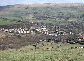
Rochdale is a town in Greater Manchester, England, and the administrative centre of the Metropolitan Borough of Rochdale. In the 2021 Census, the town had a population of 111,261, compared to 223,773 for the wider borough. Rochdale is in the foothills of the South Pennines and lies in the dale (valley) of the River Roch, 5 miles (8 km) north-west of Oldham and 10 miles (16 km) north-east of Manchester.

The Metropolitan Borough of Oldham is a metropolitan borough of Greater Manchester in England. It is named after its largest town, Oldham. The borough had a population of 243,912 in 2022, making it the sixth-largest district by population in Greater Manchester. The borough spans 142 square kilometres (55 sq mi).

Milnrow is a town within the Metropolitan Borough of Rochdale, in Greater Manchester, England. It lies on the River Beal at the foothills of the South Pennines, and forms a continuous urban area with Rochdale. It is 2 miles (3.2 km) east of Rochdale town centre, 10 miles (16.1 km) north-northeast of Manchester, and spans from Windy Hill in the east to the Rochdale Canal in the west. Milnrow is adjacent to junction 21 of the M62 motorway, and includes the village of Newhey, and hamlets at Tunshill and Ogden.

Middleton is a town in the Metropolitan Borough of Rochdale, Greater Manchester, England, on the River Irk. It is 5 miles (8.0 km) southwest of Rochdale and 5 miles (8.0 km) northeast of Manchester. Middleton had a population of 42,972 at the 2011 Census. It lies on the northern edge of Manchester, with Blackley to the south and Moston to the south east.
Littleborough is a town in the Metropolitan Borough of Rochdale, Greater Manchester, England, in the upper Roch Valley by the foothills of the South Pennines, 3 miles (4.8 km) northeast of Rochdale and 13 miles (20.9 km) northeast of Manchester; Milnrow and the M62 motorway are to the south, and the rural uplands of Blackstone Edge to the east. According to the 2001 census, Littleborough, and its suburbs of Calderbrook, Shore and Smithy Bridge, had a population of 13,807.

Heywood is a town in the Metropolitan Borough of Rochdale, Greater Manchester, England, in the historic county of Lancashire. It had a population of 28,205 at the 2011 Census. The town lies on the south bank of the River Roch, 2 miles (3.2 km) east of Bury, 4 miles (6.4 km) southwest of Rochdale, and 8 miles (12.9 km) north of Manchester. Middleton lies to the south, whilst to the north is the Cheesden Valley, open moorland, and the Pennines.

Heywood and Middleton North is a constituency in Greater Manchester represented in the House of Commons of the UK Parliament since 2024 by Elsie Blundell of the Labour Party.

Shaw and Crompton is a civil parish in the Metropolitan Borough of Oldham, Greater Manchester, England, and lies on the River Beal at the foothills of the South Pennines. It is located 2 miles (3.2 km) north of Oldham, 4 miles (6.4 km) south-east of Rochdale and 9 miles (14 km) north-east of Manchester. Its largest settlement is Shaw.

Norden is a village in the Metropolitan Borough of Rochdale, in Greater Manchester, England. It was historically part of Lancashire until 1974. It is situated on the western outskirts of the town of Rochdale.

Newhey is a village in the town of Milnrow in the Metropolitan Borough of Rochdale, in Greater Manchester, England. It lies at the foot of the South Pennines, by Junction 21 of the M62 motorway and on the River Beal, 3 miles (4.8 km) east-southeast of Rochdale, 10 miles (16.1 km) northeast of Manchester.

Rochdale Village is a housing cooperative and neighborhood in the southeastern corner of the New York City borough of Queens. Located in Community District 12, Rochdale Village is grouped as part of Greater Jamaica, corresponding to the former Town of Jamaica. It is adjacent to four other Queens neighborhoods: St. Albans to the east, South Jamaica to the west, Locust Manor to the north, and Springfield Gardens to the south across the Belt Parkway. Rochdale is about 2 miles (3.2 km) from the Queens/Nassau border and about 1 mile (1.6 km) north of John F. Kennedy International Airport.
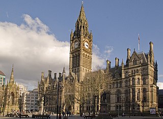
The City of Manchester forms part of the metropolitan county of Greater Manchester, which had its county council abolished in 1986. Manchester consists of several districts, but these districts do not represent a tier of government.
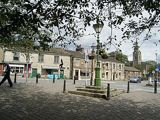
Dobcross is a village in the civil parish of Saddleworth in the Metropolitan Borough of Oldham in Greater Manchester, England. It is in a valley in the South Pennines, along the course of the River Tame and the Huddersfield Narrow Canal, 4.2 miles (6.8 km) east-northeast of Oldham and 13 miles (21 km) west-southwest of Huddersfield.

Denshaw is a village in the civil parish of Saddleworth in the Metropolitan Borough of Oldham, in Greater Manchester, England. It lies by the source of the River Tame, high amongst the Pennines above the village of Delph, 4.6 miles (7.4 km) northeast of Oldham,3.3 miles (5.3 km) north-northwest of Uppermill and Shaw and Crompton. It has a population of around 500.

Rochdale Borough Council is the local authority of the Metropolitan Borough of Rochdale in Greater Manchester, England. It is a metropolitan borough council and provides the majority of local government services in the borough. The council has been a member of the Greater Manchester Combined Authority since 2011.