Related Research Articles

Tulita, which in Slavey means "where the rivers or waters meet," is a hamlet in the Sahtu Region of the Northwest Territories, Canada. It was formerly known as Fort Norman, until 1 January 1996. It is located at the junction of the Great Bear River and the Mackenzie River; the Bear originates at Great Bear Lake adjacent to Deline.

Great Slave Lake is the second-largest lake in the Northwest Territories of Canada, the deepest lake in North America at 614 m (2,014 ft), and the tenth-largest lake in the world by area. It is 469 km (291 mi) long and 20 to 203 km wide. It covers an area of 27,200 km2 (10,500 sq mi) in the southern part of the territory. Its given volume ranges from 1,070 km3 (260 cu mi) to 1,580 km3 (380 cu mi) and up to 2,088 km3 (501 cu mi) making it the 10th or 12th largest by volume.

Wood Buffalo National Park is the largest national park of Canada at 44,741 km2 (17,275 sq mi). It is located in northeastern Alberta and the southern Northwest Territories. Larger in area than Switzerland, it is the second-largest national park in the world. The park was established in 1922 to protect the world's largest herd of free-roaming wood bison. They became hybridized after the introduction of plains bison. The population is currently estimated at about 3,000. It is one of two known nesting sites of whooping cranes.
Fort Hall was a fort in the western United States that was built in 1834 as a fur trading post by Nathaniel Jarvis Wyeth. It was located on the Snake River in the eastern Oregon Country, now part of present-day Bannock County in southeastern Idaho. Wyeth was an inventor and businessman from Boston, Massachusetts, who also founded a post at Fort William, in present-day Portland, Oregon, as part of a plan for a new trading and fisheries company. Unable to compete with the powerful British Hudson's Bay Company, based at Fort Vancouver, in 1837 Wyeth sold both posts to it. Great Britain and the United States both operated in the Oregon Country in these years.

The Liard River of the North American boreal forest flows through Yukon, British Columbia and the Northwest Territories, Canada. Rising in the Saint Cyr Range of the Pelly Mountains in southeastern Yukon, it flows 1,115 km (693 mi) southeast through British Columbia, marking the northern end of the Rocky Mountains and then curving northeast back into Yukon and Northwest Territories, draining into the Mackenzie River at Fort Simpson, Northwest Territories. The river drains approximately 277,100 km2 (107,000 sq mi) of boreal forest and muskeg.
Fort Edmonton was the name of a series of trading posts of the Hudson's Bay Company (HBC) from 1795 to 1914, all of which were located on the north banks of the North Saskatchewan River in what is now central Alberta, Canada. It was one of the last points on the Carlton Trail, the main overland route for Metis freighters between the Red River Colony and the points west and was an important stop on the York Factory Express route between London, via Hudson Bay, and Fort Vancouver in the Columbia District. It also was a connection to the Great Northland, as it was situated relatively close to the Athabasca River whose waters flow into the Mackenzie River and the Arctic Ocean. Located on the farthest north of the major rivers flowing to the Hudson Bay and the HBC's shipping posts there, Edmonton was for a time the southernmost of the HBC's forts.

Fort Smith is a town in the South Slave Region of the Northwest Territories (NWT), Canada. It is located in the southeastern portion of the Northwest Territories, on the Slave River and adjacent to the Alberta border along the 60th parallel north.
Fort Providence is a hamlet in the South Slave Region of the Northwest Territories, Canada. Located west of Great Slave Lake, it has all-weather road connections by way of the Yellowknife Highway branch off the Mackenzie Highway, and the Deh Cho Bridge opened November 30, 2012, near Fort Providence over the Mackenzie. The bridge replaced the ice bridge and ferry, enabling year-round crossing of the river.
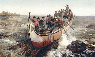
Fur brigades were convoys of canoes and boats used to transport supplies, trading goods and furs in the North American fur trade industry. Much of it consisted of native fur trappers, most of whom were Métis, and fur traders who traveled between their home trading posts and a larger Hudson's Bay Company or Northwest Company post in order to supply the inland post with goods and supply the coastal post with furs.
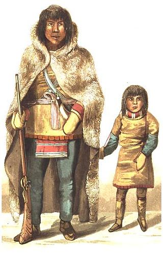
The Yellowknives, Yellow Knives, Copper Indians, Red Knives or T'atsaot'ine are indigenous peoples of Canada, one of the five main groups of the First Nations Dene who live in the Northwest Territories. The name, which is also the source for the later community of Yellowknife, derives from the colour of the tools made from copper deposits.

Behchokǫ̀, officially the Tłı̨chǫ Community Government of Behchokǫ̀, is a community in the North Slave Region of the Northwest Territories, Canada. Behchokǫ̀ is located on the Yellowknife Highway, on the northwest tip of Great Slave Lake, approximately 110 km (68 mi) northwest of Yellowknife.

Łutselkʼe, also spelt Łutsël Kʼé, is a "designated authority" in the North Slave Region of the Northwest Territories, Canada. The community is located on the south shore near the eastern end of Great Slave Lake and until 1 July 1992, it was known as Snowdrift, as the community lies near the mouth of the Snowdrift River.

The history of the Northwest Territories covers the period from thousands of years ago to the present day. Prior to European colonization, the lands that encompass present-day Northwest Territories were inhabited for millennia by several First Nations. European explorers and fur traders began to explore the region since the late-16th century. By the 17th century, the British laid claim to both the North-Western Territory and Rupert's Land; and granted the Hudson's Bay Company a commercial fur trade monopoly over the latter region.
Old Fort Providence, located near the mouth of Yellowknife Bay, Northwest Territories, Canada, was one of the first fur trading outposts on Great Slave Lake. Peter Pond of the North West Company first proposed trading with the Dene around Great Slave Lake in 1786. In 1789, Alexander Mackenzie initiated a period of trade with the Yellowknives and Tłı̨chǫ Dene and instructed his assistant, Laurent Leroux, to start a trading post in this area. The post was not a major centre for fur trading and was used primarily as a supply centre for other, more important trading posts or expeditions. It served, for example, as a base of supply for Sir John Franklin's Coppermine expedition towards the Arctic Ocean in 1820. It was located within a productive fishery used for generations by the Dene around Yellowknife Bay and helped supply meat and fish for traders at Great Slave Lake. The Hudson's Bay Company took over the post in 1821 after the demise of the North West Company, but the settlement was in decline and it closed in 1823. The buildings have long since decayed but the ruins were excavated in 1969-1971.

Oregon pioneer history (1806–1890) is the period in the history of Oregon Country and Oregon Territory, in the present day state of Oregon and Northwestern United States.

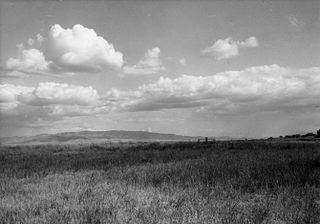
The Northwest Territories is a territory in Northern Canada, specifically in Northwestern Canada between Yukon Territory and Nunavut including part of Victoria Island, Melville Island, and other islands on the western Arctic Archipelago. Originally a much wider territory enclosing most of central and northern Canada, the Northwest Territories was created in 1870 from the Hudson's Bay Company's holdings that were sold to Canada from 1869-1870. In addition, Alberta and Saskatchewan were formed from the territory in 1905. In 1999, it was divided again: the eastern portion became the new territory of Nunavut. Yellowknife stands as its largest city and capital. It has a population of 42,800 and has an area of 532,643 sq mi (1,379,540 km2). The current territory lies west of Nunavut, north of latitude 60° north, and east of Yukon.
The history of Yukon covers the period from the arrival of Paleo-Indians through the Beringia land bridge approximately 20,000 years ago. In the 18th century, Russian explorers began to trade with the First Nations people along the Alaskan coast, and later established trade networks extending into Yukon. By the 19th century, traders from the Hudson's Bay Company were also active in the region. The region was administered as a part of the North-Western Territory until 1870, when the United Kingdom transferred the territory to Canada and it became the North-West Territories.

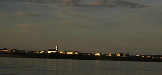
Île-à-la-Crosse is a northern village in Division No. 18, northwestern Saskatchewan, and was the site of historic trading posts first established in 1778. Île-à-la-Crosse is the second oldest community in Saskatchewan, Canada, following establishment of the Red River Colony in 1811. It sits at the end of a 20 km (12 mi) long peninsula on the western shore of Lac Île-à-la-Crosse, and is linked with Peter Pond Lake and Churchill Lake through a series of interconnected lakes, rivers, and portage routes.

The Mackenzie River in Canada's Northwest Territories is a historic waterway, used for centuries by Indigenous peoples, specifically the Dene, as a travel and hunting corridor. Also known as the Deh Cho, it is part of a larger watershed that includes the Slave, Athabasca, and Peace rivers extending from northern Alberta. In the 1780s, Peter Pond, a trader with the North West Company became the first known European to visit this watershed and begin viable trade with the Athapascan-speaking Dene of these rivers. The Mackenzie River itself, the great waterway extending to the Arctic Ocean, was first put on European maps by Alexander Mackenzie in 1789, the Scottish trader who explored the river. The watershed thus became a vital part of the North American fur trade, and before the advent of the airplane or road networks, the river was the only communication link between northern trading posts and the south. Water travel increased in the late 19th century as traders, dominated primarily by the Hudson's Bay Company (HBC), looked to increase water services in the Mackenzie River District.

The Taltson River is a roughly 500 km (310 mi) river in the Northwest Territories of Canada that drains into the Great Slave Lake. There are three hydroelectric power control structures on the river, and one power station.
References
- ↑ Smith, David. "Moose-Deer Island House People: A History of the Native People of Fort Resolution" National Museum of Man Mercury Series, Canadian Ethnology Service, Paper No. 81, 1982
- ↑ Usher, Peter "Fur Trade Posts of the Northwest Territories 1870-1970" Northern Science Research Group, Department of Indian Affairs and Northern Development, March 1971
- ↑ The Moccasin Telegraph, Summer 1944
- ↑ The News of the North, March 3, 1960
- ↑ Tapwe newspaper, December 24, 1964