
Goochland County is a county located in the Commonwealth of Virginia. Its southern border is formed by the James River. As of the 2010 census, the population was 21,717. Its county seat is Goochland.

State Route 6 is a primary state highway in the U.S. state of Virginia. Known for most of its length as River Road, the state highway runs 102.26 miles (164.57 km) from U.S. Route 250 in Afton east to SR 161 in Richmond. SR 6 is one of the main highways of mountainous Nelson County, where the highway runs north–south from its beginning to US 29. From Scottsville to Richmond, the state highway parallels the James River. SR 6 is a major suburban highway through southwestern Henrico County and the main street of Richmond's West End.

J. Sargeant Reynolds Community College (Reynolds) is a community college in Virginia with three campuses: Parham Road Campus in Henrico County, Downtown Campus in the City of Richmond and Goochland Campus in the community of Goochland Courthouse. Named for Lieutenant Governor J. Sargeant Reynolds, Reynolds is a member of the Virginia Community College System.
Goochland is a census-designated place (CDP) in and the county seat of Goochland County, Virginia, United States. The population as of the 2010 census was 861. The community is also known as Goochland Courthouse or by an alternative spelling, Goochland Court House. It derives its name from the fact that the community is the location of the county's court house.
The James River District is a high school conference of the Virginia High School League which draws most of its members from Southside Virginia. The schools in the James River District compete in A Region B with the schools of the A Bull Run District, A Dogwood District, and the A Shenandoah District.

State Route 45 is a primary state highway in the U.S. state of Virginia. The state highway runs 39.72 miles (63.92 km) from the junction of U.S. Route 15 Business and US 460 Business in Farmville north to SR 6 at Georges Tavern. SR 45 is the primary north–south highway of Cumberland County, where the highway meets US 60 near the county seat, Cumberland.

State Route 271 is a primary state highway in the U.S. state of Virginia. Known as Pouncey Tract Road, the state highway runs 7.34 miles (11.81 km) from U.S. Route 250 in Short Pump north to SR 620 and SR 622 in Rockville. A small section of it was first added to the state highway system as State Route 431 in 1930. By 1940, it had gained its current routing and designation.
George Washington Hopkins was a nineteenth-century United States politician, diplomat, lawyer, judge and teacher.
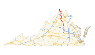
U.S. Route 522 is a part of the U.S. Highway System that runs from Powhatan, Virginia to Selinsgrove, Pennsylvania. In Virginia, the U.S. highway runs 159.65 miles (256.93 km) from its southern terminus at US 60 in Powhatan north to the West Virginia state line near Cross Junction. In the Piedmont of central Virginia, US 522 is a minor highway connecting several county seats, including Powhatan, Goochland, and Culpeper. North of Culpeper, the U.S. highway increases in importance, crossing the Blue Ridge Mountains, connecting Culpeper with Sperryville and Front Royal. US 522 is mostly a four-lane divided highway north of Front Royal, where it passes through the Shenandoah Valley and the city of Winchester on its way to the Eastern Panhandle of West Virginia. The U.S. highway is part of the National Highway System from SR 37 near Winchester north to the West Virginia state line.
WJFN is a News and Conservative Talk-formatted broadcast radio station licensed to Goochland, Virginia, serving Goochland and Goochland County, Virginia. WJFN is owned by Stu and Nancy Epperson, through licensee Truth Broadcasting Corporation, and operated by John Fredericks through his MAGA Radio Network. Fredericks hosts the weekday morning show at the station, with other daily shows including syndicated talkers Michael Savage and Dennis Prager.

This is a list of the National Register of Historic Places listings in Goochland County, Virginia.
Henry L. Hopkins was a nineteenth century American politician from Virginia.

Sandy Hook is an unincorporated community in Goochland County, Virginia, United States. Sandy Hook is located on U.S. Route 522 5 miles (8.0 km) north-northwest of Goochland. Sandy Hook has a post office with ZIP code 23153.

Clover Forest Plantation, located in Goochland, Virginia between Richmond and Charlottesville, is an authentically restored plantation on the upper James River, in the Piedmont. It has a Federal-style mansion, with portions dating to pre-Revolutionary America; terraced landscaped grounds, and a private lake. The property lies in a large bend of the James River.
Pemberton is an unincorporated community in Goochland County, Virginia, United States. Virginia State Route 45 passes by Pemberton, located about 11 miles (18 km) west of Goochland, the county seat. It was named for the family that owned Clover Forest Plantation. Nearby is Howard's Neck Plantation, listed on the National Register of Historic Places.
Goochland County Court Square is a historic county courthouse and national historic district located at Goochland, Goochland County, Virginia. It includes three contributing buildings and one contributing site. The Goochland County Court House was built in 1826 by Dabney Cosby, an architect of the area. It is a two-story, temple-form brick structure with a projecting pedimented tetrastyle Tuscan order portico.
Virginia's 56th House of Delegates district elects one of 100 seats in the Virginia House of Delegates, the lower house of the state's bicameral legislature. District 56 includes Louisa County, as well as portions of Goochland, Henrico, and Spotsylvania counties. It has been represented by Republican John McGuire III since 2018.


