The history of Trinidad and Tobago begins with the settlements of the islands by Amerindians, specifically the Island Carib and Arawak peoples. Both islands were visited by Christopher Columbus on his third voyage in 1498 and claimed in the name of Spain. Trinidad remained in Spanish hands until 1797, but it was largely settled by French colonists. Tobago changed hands between the British, French, Dutch, and Courlanders, but eventually ended up in British hands following the second Treaty of Paris (1814). In 1889 the two islands were incorporated into a single crown colony. Trinidad and Tobago obtained its independence from the British Empire in 1962 and became a republic in 1976.

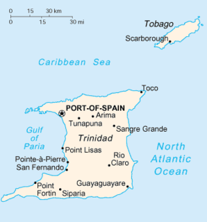
Trinidad and Tobago is an archipelagic republic in the southern Caribbean between the Caribbean Sea and the North Atlantic Ocean, northeast of Venezuela. They are southeasterly islands of the Lesser Antilles, Monos, Huevos, Gaspar Grande, Little Tobago, and St. Giles Island. Trinidad is 11 km (6.8 mi) off the northeast coast of Venezuela and 130 km (81 mi) south of the Grenadines. The island measures 4,768 km2 (1,841 sq mi) in area with an average length of 80 km (50 mi) and an average width of 59 km (37 mi). The island appears rectangular in shape with three projecting peninsular corners. Tobago is 30 km (19 mi) northeast of Trinidad and measures about 298 km2 (115 sq mi) in area, or 5.8% of the country's area, 41 km (25.5 mi) in length and 12 km (7.5 mi) at its greatest width. The island is cigar-shaped in appearance, with a northeast-southwest alignment.

The Trinidad and Tobago Defence Force (TTDF) is the military organization responsible for the defence of the twin island Republic of Trinidad and Tobago. It consists of the Trinidad and Tobago Regiment, the Trinidad and Tobago Coast Guard, the Trinidad and Tobago Air Guard and the Defence Force Reserves.

Tobago is an island within the Republic of Trinidad and Tobago. It is located 35 kilometres (22 mi) northeast of the mainland of Trinidad and southeast of Grenada, about 160 kilometres (99 mi) off the coast of northeast Venezuela. According to the earliest English-language source cited in the Oxford English Dictionary, Tobago bore a name that has become the English word tobacco. The official bird of Tobago is the cocrico.
Trinidad is the larger and more populous of the two major islands of Trinidad and Tobago. The island lies 11 km (6.8 mi) off the northeastern coast of Venezuela and sits on the continental shelf of South America. It is often referred to as the southernmost island in the Caribbean. With an area of 5,131 km2 (1,981 sq mi), it is also the fifth largest in the West Indies.

Hoffman Island is an 11-acre (4.5 ha) artificial island in the Lower New York Bay, off the South Beach of Staten Island, New York City. A smaller, 4-acre (1.6 ha) artificial island, Swinburne Island, lies immediately to the south. Created in 1873 upon the Orchard Shoal by the addition of landfill, the island is named for former New York City mayor (1866–1868) and New York Governor (1869–1871) John Thompson Hoffman.
Swinburne Island is a 4-acre (1.6 ha) artificial island in the Lower New York Bay, off the South Beach of Staten Island, New York City. It was used for quarantine of immigrants. Swinburne Island is the smaller of two islands near South Beach, the other being Hoffman Island.

Huevos is an island in the Republic of Trinidad and Tobago. The island is 1.01 km2 in area. It is one of the "Bocas Islands", which lie in the Bocas del Dragón between Trinidad and Venezuela.

Chacachacare is an island in the Republic of Trinidad and Tobago, located at 10° 41' north latitude and 61° 45' west longitude. The island is 360 hectares in area.

Nelson Island, Trinidad and Tobago is one of the Five Islands which lie west of Port of Spain in the Gulf of Paria.

Trinidad and Tobago, officially the Republic of Trinidad and Tobago, is the southernmost island country in the Caribbean and is known for its fossil-fuel wealth. Consisting of the main islands Trinidad and Tobago, and numerous much smaller islands, it is situated 130 kilometres south of Grenada and 11 kilometres off the coast of northeastern Venezuela. It shares maritime boundaries with Barbados to the northeast, Grenada to the northwest, Guyana to the southeast, and Venezuela to the south and west.

The Catholic Church in Trinidad and Tobago is part of the worldwide Catholic Church, under the spiritual leadership of the Pope in Rome. The Apostolic Nuncio to Trinidad and Tobago is, since December 2011, Archbishop Nicola Girasoli, who is also Apostolic Nuncio to other independent states and Apostolic Delegate for the dependent territories in the Caribbean area.

Gasparillo is a small island in the Republic of Trinidad and Tobago. It is one of the Bocas Islands, which lie in the Bocas del Dragón between the main island of Trinidad and Venezuela. The island is currently uninhabited.
Soldado Rock or Soldier's Rock, formerly known as Soldado Island, is a small island in the Republic of Trinidad and Tobago. It is located in the Gulf of Paria 10 km off Icacos Point in Trinidad and north of the Venezuelan mainland. The island was originally a possession of the Venezuelan government, but became part of the territory of Trinidad and Tobago in 1942. The island is a wildlife sanctuary since being declared in 1934.

Saut d'Eau, French for "Waterfall", is a small island in the Republic of Trinidad and Tobago. It is located just off the north coast of main island of Trinidad in the Caribbean Sea. It is one of thirteen government protected wildlife sanctuaries, one of two breeding grounds for pelicans in the country.
Patos Island is a small uninhabited island in the northwestern Gulf of Paria. The island is a part of the Dependencias Federales of Venezuela.
The Chief Justice of Trinidad and Tobago is the highest judge of the Republic of Trinidad and Tobago and presides over its Supreme Court of Judicature. He is appointed by a common decision of the president, the prime minister and the leader of the main opposition party.

The COVID-19 pandemic in Trinidad and Tobago is part of the ongoing global viral pandemic of coronavirus disease 2019 (COVID-19), which was confirmed to have reached the Republic of Trinidad and Tobago on 12 March 2020.


