Onota Township is a civil township of Alger County in the U.S. state of Michigan. As of the 2010 census, the township population was 352.

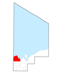
Rock River Township is a civil township of Alger County in the U.S. state of Michigan. The population was 1,212 at the 2010 census.

Hiawatha National Forest is a 894,836-acre (362,127 ha) National Forest in the Upper Peninsula of the state of Michigan in the United States. Commercial logging is conducted in some areas. The United States Forest Service administers this National Forest; it is physically divided into two subunits, commonly called the Eastside 46°14′N84°50′W and Westside 46°08′N86°40′W. In descending order of land area it lies in parts of Chippewa, Delta, Mackinac, Alger, Schoolcraft, and Marquette counties. Chippewa and Mackinac counties are in the Eastside, whereas the rest are in the Westside. The smaller Eastside contains about 44% of the forest's area, whereas the larger Westside has about 56%. Forest headquarters are located in Escanaba, Michigan. Eastside ranger district offices are located in Sault Ste. Marie and St. Ignace, while Westside offices are in Manistique, Munising, and Rapid River.
The Little Indian River is a 12.8-mile-long (20.6 km) river on the Upper Peninsula of the U.S. state of Michigan. It rises in a small lake on Hiawatha National Forest land in Alger County, Michigan at 46°18′02″N86°38′12″W, flows through a lake district, then on through Schoolcraft County, and into the Indian River at 46°11′24″N86°31′35″W.
The Anna River is a 7.1-mile-long (11.4 km) river on the Upper Peninsula of the U.S. state of Michigan. The mouth of the river is at 46°24′40″N86°38′26″W in the city of Munising on the South Bay of Grand Island Harbor on Lake Superior.
Mill Creek is an 8.7-mile-long (14.0 km) tributary stream of Patterson Creek in Mineral County, West Virginia. It is also known as Mill Run.
Carp River is a 40.2-mile-long (64.7 km) river in Chippewa and Mackinac counties in the U.S. state of Michigan. 21.7 miles (34.9 km) of the river were added to the National Wild and Scenic Rivers System in 1992.

The Presque Isle River runs 42.1 miles (67.8 km) through the Upper Peninsula of Michigan and empties into Lake Superior. Along its course, it flows through the Ottawa National Forest and Porcupine Mountains Wilderness State Park. It has 300 square miles (780 km2) of drainage area in Upper Michigan and northern Wisconsin.
The Whitefish River is an 11.9-mile-long (19.2 km) river on the Upper Peninsula of the U.S. state of Michigan. The mouth of the river is in Delta County at 45°54′34″N86°58′01″W on the Little Bay De Noc of Lake Michigan. The main branch of the river is formed by the confluence of the east and west branches at 46°03′25″N86°52′17″W.

The Cheboygan River is a short but significant river in the Lake Huron drainage basin of the U.S. state of Michigan.
The Iron River is a 17.1-mile-long (27.5 km) river in Iron County, Michigan, in the United States. It flows from northwest to southeast through the city of Iron River to the Brule River. It is part of the Menominee River watershed, flowing to Lake Michigan.
The Murphy River is a 6.6-mile-long (10.6 km) river in Baraga County on the Upper Peninsula of Michigan in the United States. It is a tributary of Worm Lake, the outlet of which is the Rock River, which flows to the Sturgeon River and eventually to Lake Superior.
The Net River is a 14.9-mile-long (24.0 km) river in Michigan in the United States. Its headwaters rise in Baraga County and flow southwest into Iron County, where the main stem forms and flows to the Paint River above Crystal Falls.
The Pentwater River is a 10.8-mile-long (17.4 km) river in Oceana County, Michigan, in the United States. It rises east of Hart at the inflow of the South Branch Pentwater River and flows northwest to Lake Michigan at the village of Pentwater.
The Peshekee River is a 31.1-mile-long (50.1 km) river on the Upper Peninsula of Michigan in the United States. It is a tributary of Lake Michigamme, and its waters flow via the Michigamme River and the Menominee River to Lake Michigan.
The Sebewaing River is a river in Michigan that flows through Sebewaing Township, Michigan and empties into Saginaw Bay.

Sturgeon River may refer to any of the following streams in the U.S. state of Michigan:
Sturgeon River is a 63.6-mile-long (102.4 km) river in the U.S. state of Michigan, flowing mostly southward through Alger County and Delta County counties on the Upper Peninsula.

Indian River is a 59.1-mile-long (95.1 km) tributary of the Manistique River on the Upper Peninsula of Michigan in the United States. It rises out of Hovey Lake at 46°17′36″N86°42′20″W on Hiawatha National Forest land in Alger County and flows south and east through a lake district and on through Schoolcraft County. The river flows into the 8,659 acre (35 km²) Indian Lake at 46°17′36″N86°42′20″W and flows out at 45°59′30″N86°17′15″W. It then flows east and south about 2.5 miles where it merges with the Manistique River, which then flows through Manistique and into Lake Michigan at 45°56′56″N86°14′45″W.
The Rock River is a 6.1-mile-long (9.8 km) stream in Baraga County on the Upper Peninsula of Michigan in the United States. It rises at the outlet of Worm Lake, east of Covington, and flows northwest to the Sturgeon River, which continues west, then north to Portage Lake and Lake Superior. The Rock River descends 350 feet (110 m) over its 6-mile (10 km) course, for an average rate of 58 feet per mile.


