Rockdale, Iowa

Last updated

Rockdale, Iowa was a small unincorporated village formerly located just south of Dubuque, Iowa [1] between Dubuque and Key West, Iowa. The village was situated on the Catfish Creek in Dubuque County, Iowa, and was the site of one of the first mills in the state of Iowa.

Contents

In 1834 or 1835 David Hutton and his son built a mill built of logs. Initially the mill was known as "The Catfish Mills." In 1839 the mill was sold. James Pratt and Walter Manson purchased the mill in 1840, and they renamed the mill "Rockford Mill." They replaced the original log building with a frame building four stories high. This mill could produce 90,000 bushels of wheat annually, and the flour produced was equal in quality to the flour produced in St. Louis, Missouri. As a result, the mill enjoyed a monopoly in the upper Midwest until the establishment of other mills. Pratt and Manson would operate this mill for the next 25 years. [2] During this time Rockdale was a crossroads for farmers in the area.

Operations at the Rockdale Mill were temporarily halted due to the Rockdale Flood. The mill would eventually start producing flour once again. In 1878 the mill burned to the ground. Thomas Watters Jr. rebuilt the mill as a stone structure. He changed the name to the South Dubuque Mill. J.F. Gondolfo would purchase the mill in 1885. He made repairs, and the mill continued to produce flour for a number of years. In 1901 the mill would be leased out to a company that ran the mill for the next 14 years. In 1915 the mill was finally shut down. For a time it was used as a dairy barn until it was destroyed by fire in 1927.

The village would eventually grow to include a saloon, hotel, stores, blacksmith shop, several homes, and a post office. The villagers built a Methodist church built out of logs in the 1830s. In 1874 the present structure was built at 1500 Old Mill Road with red brick. The Rockdale Methodist Church still stands and, along with its Cemetery at the side and back, is still in use today. [3]

Rockdale's population was 132 in 1902, [4] and was 85 in 1925. [5]

The Rockdale Flood

On July 4, 1876, Rockdale would be the site of one of the worst flooding disasters in the history of the area. For most of the day those living in the area celebrated the 100th anniversary of the nation. As night approached the celebrations wrapped up. Around 10 p.m. a light drizzle began falling. Soon this drizzle turned into a downpour of rain. The Catfish Creek soon jumped out of its bank and broke the mill dam which was upstream of the village.

The resulting wall of water – which was estimated to be 20 feet deep and hundreds of feet wide – swept through the village. By the time the flood was over, the mill and one house would be the only buildings still standing. In Rockdale forty-two people died in the flood, while in Dubuque only one person died. Survivors were found in the tree tops where the flood waters had swept them. Charles Thimmesch – a local barkeeper – survived with an incredible tale of escape. He had climbed on the roof of the post office after warning others of the flood. Thimmesch escaped by swimming naked to higher ground with his money in his mouth. As a result of the destruction, the village was never the same. Most of the people living in the village had died during the floods.

John and Frances Howell wrote home to family in England from USA in a letter of July 12, 1876:

... The crops here will not be good here, there has been so great falls of rain that has done a vast deal of damage. I dare say your Brother Joe can remember Cat Fish Mill. On the 4th July, the great day of rejoicing all over America, at night set in such violent a storm of rain as was ever known here. by Catfish Mill there was a little village of 12 or 13 houses. all had been at the great rejoicings and came home tired and returned to rest, and all families drowned in a few hours after. 39 men, women, and children, all but a young man and one family who were saved almost miraculously. their house turned on one side and was stopped by a big tree. they clung to the rafters with their heads just above water and held on until help came to them. I cannot sleep well for thinking of those dear children. The house was knocked to fragments and up to the 8th, 31 dead bodies were found. Hundreds of people have been to see where they stood. But the mill, which was built of large stone, turned the flood on one side and is still alright. You may conject what a flood, 25 feet deep, came rushing down and swept all away. There is a great deal of damage done at many places and the Rail Roads washed away, and many persons lost their lives. This year appears to be a year of great floods and fires. ...

The family that survived the flood was the Gustav A Horn family headed by Gustav and Helene Augusta Dettmer. They had five children: Emeila C (born 1862), Bertha Helene (b. 1864), Ida (b. 1866), Caroline (b.1868) and Albert A (b.1872). Gustav immigrated from Dosenau, Schleswig-Holstein. They had the general store in Rockdale. He planted Lombardy Poplar trees on their property in memory of his childhood home in Germany. The elder Horns always intended to return home to Germany. When the flood waters rose, they scrambled up into the attic rafters. With the water just below them, the little boy, Albert became confused, and said to his father, "But Papa, I don't want to go back to Germany". The story, handed down the generations, was that they were the only family to survive in its entirety, and that Lombardy trees were the only thing that saved them. Gustav had a sketch that he drew of his childhood home that also survived the flood, albeit with flood mud on it.

Aftermath

Along with the floods, the shutting down of the mill and eventual construction of highways for automobile traffic would mean the end of Rockdale as a crossroads. The highways built all bypassed the Rockdale area. The Rockdale area was annexed by the city of Dubuque, and is now entirely within the city. While some local commuter traffic passes through the area due to Kelly Lane being nearby, most traffic uses U.S. Highway 151 and 61 and completely bypasses the area.

Related Research Articles

<span class="mw-page-title-main">Dubuque, Iowa</span> City in Iowa, United States

Dubuque is the county seat of Dubuque County, Iowa, located along the Mississippi River. At the time of the 2020 census, the population of Dubuque was 59,667. The city lies at the junction of Iowa, Illinois, and Wisconsin, a region locally known as the Tri-State Area. It serves as the main commercial, industrial, educational, and cultural center for the area. Geographically, it is part of the Driftless Area, a portion of North America that escaped all three phases of the Wisconsin Glaciation.

<span class="mw-page-title-main">Cedar Rapids, Iowa</span> City in Iowa, United States

Cedar Rapids is the second-largest city in Iowa, United States and is the county seat of Linn County. The city lies on both banks of the Cedar River, 20 miles (32 km) north of Iowa City and 100 miles (160 km) northeast of Des Moines, the state's capital and largest city. It is a part of the Cedar Rapids/Iowa City region of Eastern Iowa, which includes Linn, Benton, Cedar, Iowa, Jones, Johnson, and Washington counties.

<span class="mw-page-title-main">Saint Anthony Falls</span> Waterfall in Mississippi River into the Mississippi River Gorge in Minneapolis, Minnesota

Saint Anthony Falls, or the Falls of Saint Anthony located at the northeastern edge of downtown Minneapolis, Minnesota, is the only natural major waterfall on the Mississippi River. Throughout the mid-to-late 1800’s, various dams were built atop the east and west faces of the falls to support the milling industry that spurred the growth of the city of Minneapolis. In 1880, the central face of the falls was reinforced with a sloping timber apron to stop the upstream erosion of the falls. In the 1950s, the apron was rebuilt with concrete, which makes up the most visible portion of the falls today. A series of locks were constructed in the 1950s and 1960s to extend navigation to points upstream.

<span class="mw-page-title-main">Julien Dubuque</span> French-Canadian trader known for lead mining with Meskwaki Indians

Julien Dubuque was a Canadian of Norman origin from the area of Champlain, Quebec who arrived near what now is known as Dubuque, Iowa, which was named after him. He was one of the first European men to settle in the area. He initially received permission from the Mesquakie Indian tribe to mine the lead in 1788, which was confirmed by the Spanish, who gave him a land grant in 1796.

<span class="mw-page-title-main">Log cabin</span> Dwelling constructed of logs; mostly used in a log house

A log cabin is a small log house, especially a less finished or less architecturally sophisticated structure. Log cabins have an ancient history in Europe, and in America are often associated with first generation home building by settlers.

Malin Bridge is a suburb of the city of Sheffield, England. It is located at grid reference SK325893 and stands 2½ miles north-west of the city centre where the rivers Loxley and Rivelin meet. Malin Bridge is only a small district centred on the road bridge over the River Loxley which carries the B6076 road to Stannington ; it is surrounded by the suburbs of Hillsborough, Wisewood, Walkley and Stannington.

<span class="mw-page-title-main">Lincoln's New Salem</span> Historic reconstruction of 1830s village associated with Abraham Lincoln

Lincoln's New Salem State Historic Site is a reconstruction of the former village of New Salem in Menard County, Illinois, where Abraham Lincoln lived from 1831 to 1837. While in his twenties, the future U.S. President made his living in this village as a boatman, soldier in the Black Hawk War, general store owner, postmaster, surveyor, and rail splitter, and was first elected to the Illinois General Assembly.

The Driftless Area, a topographical and cultural region in the American Midwest, comprises southwestern Wisconsin, southeastern Minnesota, northeastern Iowa, and the extreme northwestern corner of Illinois.

<span class="mw-page-title-main">Tornado outbreak sequence of March 1913</span> Severe 1913 windstorm in the central and southern United States

The tornado outbreak sequence of March 1913 was a devastating series of tornado outbreaks that affected the northern Great Plains, the Southern United States, and sections of the upper Midwest over a two-day-long period between March 21–23, 1913. Composed of two outbreaks, the sequence first began with a tornado outbreak that commenced in Mississippi early on March 21. Several significant tornadoes occurred, one of which killed seven people in one family and another destroyed much of Lower Peach Tree, Alabama, with 27 deaths all in that town. The tornado at Lower Peach Tree is estimated to have been equivalent to a violent F4 tornado on the Fujita scale, based upon damage accounts. The tornadoes occurred between 0630–1030 UTC, or pre-dawn local time, perhaps accounting for the high number of fatalities—a common trend in tornadoes in the Dixie Alley. In all, tornadoes in Mississippi, Georgia, and Alabama killed 48 people, perhaps more, that day and injured at least 150 people.

<span class="mw-page-title-main">History of Dubuque, Iowa</span>

The city of Dubuque, Iowa stretches back over 200 years, when Julien Dubuque first settled in the area in the late 18th century. A number of forces shaped the city into what it is today.

Gustav A. Oelwein was the founder of the city of Oelwein, Iowa in the United States.

<span class="mw-page-title-main">Besthorpe, Nottinghamshire</span> Village in Nottinghamshire, England

Besthorpe is a small village in north-east Nottinghamshire close to the border with Lincolnshire. It is a Civil Parish in the Newark & Sherwood district of Nottinghamshire. The population of the civil parish as of the 2011 census is 195. The village is on the A1133 between Newark and Gainsborough, and is 1.5 miles north of the larger village of Collingham, north east of Newark on Trent. The village lies 1 mile east of the River Trent and the River Fleet flows south to east parallel with the village & A1133. Besthorpe acquired Conservation Village status in 2006 because it has maintained much of its original layout focused on Low Road and the Green.

<span class="mw-page-title-main">Walkerburn</span> Human settlement in Scotland

Walkerburn is a small village in the Scottish Borders area of Scotland, on the A72 about 8 miles (13 km) from Peebles and 10 miles (16 km) from Galashiels.

<span class="mw-page-title-main">Center Grove, Iowa</span>

Center Grove, Iowa was a community located just to the west of Dubuque, Iowa. Located in section 27 of Dubuque Township in Dubuque County, Iowa, the town was named Center Grove because of the juniper trees found in the area. Center Grove was located near what today is known as U.S. Highway 20 and Devon Drive.

<span class="mw-page-title-main">Port of Dubuque</span>

The Port of Dubuque is the section of downtown Dubuque, Iowa that lies immediately adjacent to the Mississippi River. The area was among the first areas settled in what would become the City of Dubuque, and the State of Iowa. Historically, the area has been a center of heavy industry, but has recently seen extensive reinvestment and new construction. The area is now one of the main tourist destinations in Dubuque, as well as Iowa.

<span class="mw-page-title-main">Timothy Davis (Iowa politician)</span> American politician

Timothy Davis was an attorney, businessman, and politician in Missouri and Iowa. He is most notable for his service as a one-term U.S. Representative from Iowa's 2nd congressional district.

Neepsend is a suburb of the city of Sheffield, it stands just 1 mile (1.6 km) north-west of the city centre. The main area of Neepsend covers the flood plain of the River Don from Lady's Bridge at the Wicker up to Hillfoot Bridge. The suburb falls within the Central Ward of the City. The adjacent district of Parkwood Springs is often regarded as part of the suburb.

<span class="mw-page-title-main">Mines of Spain State Recreation Area and E. B. Lyons Nature Center</span> State park in Dubuque County, Iowa, United States

The Mines of Spain State Recreation Area and E. B. Lyons Nature Center is a state park in Dubuque County, Iowa, United States. It is near Dubuque, the eighth-largest city in the state. The park features picnic areas, 15 miles (24 km) of walking/hiking trails, 4 miles (6.4 km) of ski trails, and the Betty Hauptli Bird and Butterfly Garden. It also includes archaeological sites of national importance as an early lead mining and smelting venture led by French explorer Julien Dubuque, as well as Dubuque's gravesite. These sites were collectively designated a National Historic Landmark District as Julien Dubuque's Mines.

<span class="mw-page-title-main">Pine Creek Gristmill</span> United States historic place

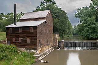
Pine Creek Gristmill is a historic building located in Wildcat Den State Park in Muscatine County, Iowa, United States. The building was listed on the National Register of Historic Places in 1979.

<span class="mw-page-title-main">Bee Branch Creek (Iowa)</span> River in Iowa

The Bee Branch Creek is a creek in Dubuque, Iowa, that flows into the Mississippi River. The city has modified it multiple times over the years to combat flooding. The most recent involves daylighting the creek. The entire modern watershed project is expected to cost $230 million.

References

  1. "Rockdale, Iowa". Roadside Thoughts. Retrieved 20 March 2017.
  2. "ROCKDALE MILL". Encyclopedia Dubuque. Retrieved 20 March 2017.
  3. "Rockdale Methodist Cemetery". Iowa Gravestone Photo Project. Retrieved 2013-02-15.
  4. Cram's Modern Atlas: The New Unrivaled New Census Edition. J. R. Gray & Company. 1902. pp. 203–207.
  5. Premier Atlas of the World: Containing Maps of All Countries of the World, with the Most Recent Boundary Decisions, and Maps of All the States,territories, and Possessions of the United States with Population Figures from the Latest Official Census Reports, Also Data of Interest Concerning International and Domestic Political Questions. Rand McNally & Company. 1925. p. 190.

Coordinates: 42°27′51″N90°40′42″W / 42.46417°N 90.67833°W / 42.46417; -90.67833