
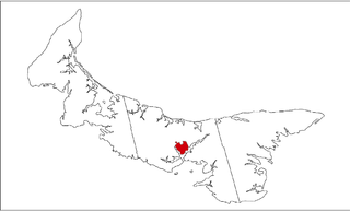
Rocky Point 3 in Prince Edward Island
Rocky Point 3 is a Mi'kmaq reserve located in Queens County, Prince Edward Island. In the 2016 Census, the reserve had 51 residents. [1]
Rocky Point 3 is a Mi'kmaq reserve located in Queens County, Prince Edward Island. In the 2016 Census, the reserve had 51 residents. [1]
Rocky Point 3 is located in the community of Rocky Point on the southwest shore of Charlottetown Harbour, approximately 16 km (9.9 mi) southeast of Cornwall.
It is administratively part of the Abegweit First Nation.

Queens County is a county in the province of Prince Edward Island, Canada. It is the largest county in the province by population with 89,770 (2021) and land. Charlottetown is the county seat of Queens County, and is the largest city and the capital of Prince Edward Island.

Kings County is located in eastern Prince Edward Island, Canada.
Cornwall is a Canadian town located in Queens County, Prince Edward Island. The town is located immediately west of the provincial capital Charlottetown.

Prince County is located in western Prince Edward Island, Canada. The county's defining geographic feature is Malpeque Bay, a sub-basin of the Gulf of St. Lawrence, which creates the narrowest portion of Prince Edward Island's landmass, an isthmus upon which the city of Summerside is located.

Kensington is a Canadian town located in Prince County, Prince Edward Island. It is 15 km (9.3 mi) northeast of the city of Summerside. In 2021, its population was 1,812 and is seeing rapid growth thanks in part to a recently opened business park.

Miscouche is a municipality that holds community status in Prince Edward Island, Canada. It is located in Prince County.
Hunter River is a municipality that holds community status in Prince Edward Island, Canada. It is located in Queens County southwest of North Rustico. It is situated on the Hunter River.
Lennox Island is a Mi'kmaq First Nations band government in the Canadian province of Prince Edward Island. Its only currently inhabited reserve is Lennox Island 1, on Lennox Island, purchased by the Aborigines' Protection Society on behalf of the Mi'kmaq of Prince Edward Island in 1870 or 1878. The population on reserve is approximately 450. In 2005 the population was 320 on reserve and 720 off reserve, with 60% of the population being younger than 35. The 2016 census counted 323 residents on reserve. The band has two other reserves, Lennox Island 5, located in East Bideford, and Lennox Island 6, located in Fernwood, both acquired in the 2000s.

Lennox Island is an island located in Malpeque Bay off the northwest coast of Prince Edward Island, Canada. Connected by a short causeway and bridge, Lennox Island is home to the Lennox Island First Nation, of the Mi'kmaq people. The Mi'kmaq name for the island is L'nui Minegoo, and it has been informally known by European settlers as Indian Island.
Sherwood is a neighbourhood of the city of Charlottetown in central Queens County, Prince Edward Island, Canada.
Winsloe is a neighbourhood in the northwestern part of the Canadian city of Charlottetown, Prince Edward Island.
East Royalty is a neighbourhood of the Canadian city of Charlottetown, Prince Edward Island.
Bedeque is a former municipality that previously held community status in the Canadian province of Prince Edward Island. It was dissolved through its amalgamation with the Community of Central Bedeque on November 17, 2014 to create the Community of Bedeque and Area.
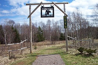
Rocky Point is a settlement in Prince Edward Island, Canada. It is part of Lot 65 in Hillsboro Parish. Rocky Point had been the location of an annual Mi'kmaq summer coastal community before European settlement.
Hillsborough Bay is a 244 km2 (94 sq mi) bay on the south shore of Prince Edward Island, Canada and is a sub-basin of the Northumberland Strait.
Wilmot is a neighbourhood in the Southeastern part of the Canadian city of Summerside, Prince Edward Island.
Long River is an unincorporated community, in Queens County. Long River is in Lot 20 of Statistics Canada

Lennox Island 1 is a Mi'kmaq reserve located in Prince County, Prince Edward Island. In the 2021 Census, the reserve has 308 residents.
Lennox Island 5 is a Mi'kmaq reserve located in Prince County, Prince Edward Island. There are currently no residents.
Lennox Island 6 is a Mi'kmaq reserve located in Prince County, Prince Edward Island. There are currently no residents.