
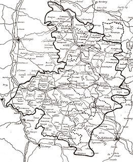
Thuringia, officially the Free State of Thuringia, is a state of central Germany, covering 16,171 square kilometres (6,244 sq mi), the sixth smallest of the sixteen German states. It has a population of about 2.1 million.

The Werra, a river in central Germany, is the right-bank headwater of the Weser. "Weser" is a synonym in an old dialect of German. The Werra has its source near Eisfeld in southern Thuringia. After 293 kilometres (182 mi) the Werra joins the river Fulda in the town of Hann. Münden, forming the Weser. If the Werra is included as part of the Weser, the Weser is the longest river entirely within German territory at 744 kilometres (462 mi).

The Leine is a river in Thuringia and Lower Saxony, Germany. It is a left tributary of the Aller and the Weser and it is 281 km (175 mi) long.
Altenburger Land is a district in Thuringia, Germany. It is bounded by the district of Greiz, the Burgenlandkreis (Saxony-Anhalt), and the districts Leipzig, Mittelsachsen and Zwickau in Saxony. The district is a member of the Central German Metropolitan Region.
Eichsfeld is a district in Thuringia, Germany, and part of the historical region of Eichsfeld. It is bounded by the districts of Nordhausen, Kyffhäuserkreis and Unstrut-Hainich-Kreis, and by the states of Hesse and Lower Saxony.
Sömmerda is a Kreis (district) in the north of Thuringia, Germany. Neighboring districts are the districts Kyffhäuserkreis, the Burgenlandkreis in Saxony-Anhalt, the district Weimarer Land and the district-free city Erfurt, and the districts Gotha and Unstrut-Hainich-Kreis.
Unstrut-Hainich-Kreis is a Kreis (district) in the north of Thuringia, Germany. Neighboring districts are the districts Eichsfeld, Kyffhäuserkreis, Sömmerda, Gotha, Wartburgkreis and the district Werra-Meißner in Hesse.
Wartburgkreis is a Kreis (district) in the west of Thuringia, Germany. Neighboring districts are the districts Unstrut-Hainich-Kreis, Gotha, Schmalkalden-Meiningen, and the districts Fulda, Hersfeld-Rotenburg and Werra-Meißner-Kreis in Hesse.
Weimarer Land is a Landkreis (district) in the east of Thuringia, Germany. Neighboring districts are the district Burgenlandkreis in Saxony-Anhalt, the district Saale-Holzland and the district-free city Jena, the district Saalfeld-Rudolstadt, Ilm-Kreis, and the district-free city Erfurt. The district-free city Weimar is completely enclosed by the district.
Saalfeld is a town in Germany, capital of the Saalfeld-Rudolstadt district of Thuringia. It is best known internationally as the ancestral seat of the Saxe-Coburg and Gotha branch of the Saxon House of Wettin.

The Unstrut is a river in Germany and a left tributary of the Saale.

Hildburghausen is a town in Thuringia in central Germany, capital of the district Hildburghausen.

Schmalkalden is a town in the Schmalkalden-Meiningen district, in the southwest of the state of Thuringia, Germany. It is on the southern slope of the Thuringian Forest at the Schmalkalde river, a tributary to the Werra. As of 31 December 2010, the town had a population of 19,978.

The Ilm is a 128.7 kilometers (80.0 mi) long river in Thuringia, Germany. It is a left tributary of the Saale, into which it flows in Großheringen near Bad Kösen.

Henry III, called Henry the Illustrious from the House of Wettin was Margrave of Meissen and last Margrave of Lusatia from 1221 until his death; from 1242 also Landgrave of Thuringia.
The Margravate of Meissen was a medieval principality in the area of the modern German state of Saxony. It originally was a frontier march of the Holy Roman Empire, created out of the vast Marca Geronis in 965. Under the rule of the Wettin dynasty, the margravate finally merged with the former Duchy of Saxe-Wittenberg into the Saxon Electorate by 1423.

The Pleiße is a river of Saxony and Thuringia, Germany.

Orlamünde is a small town in the Saale-Holzland district, in Thuringia, Germany. It is part of the Verwaltungsgemeinschaft Südliches Saaletal.

The Itz is a river of Thuringia and Bavaria, Germany.
The Duchy of Thuringia was an eastern frontier march of the Merovingian kingdom of Austrasia, established about 631 by King Dagobert I after his troops had been defeated by the forces of the Slavic confederation of Samo at the Battle of Wogastisburg. It was recreated in the Carolingian Empire and its dukes were appointed by the king until it was absorbed by the Saxon dukes in 908. From about 1111/12 the territory was ruled by the Landgraves of Thuringia as Princes of the Holy Roman Empire.
