
Andøya is the northernmost island in the Vesterålen archipelago, situated about 300 kilometres (190 mi) inside the Arctic circle. Andøya is located in Andøy Municipality in Nordland county, Norway. The main population centres on the island include the villages of Andenes, Bleik, and Risøyhamn.

Myklebost or Myklebust is a village in Ålesund Municipality in Møre og Romsdal county, Norway. It is located on the south side of the island of Ellingsøya, about 4 kilometres (2.5 mi) west of the village of Årset and about 5 kilometres (3.1 mi) east of the village of Hoffland. Myklebost is about 10 kilometres (6.2 mi) northeast of the city center of Ålesund.

Kasfjord is a village in Harstad Municipality in Troms county, Norway. The village is located at the end of the Kasfjorden on the north side of Hinnøya island, about 10 kilometres (6.2 mi) west of the town of Harstad and about 12 kilometres (7.5 mi) south of the village of Elgsnes. The Kasfjordvannet lake is located along the east side of the village. The 0.34-square-kilometre (84-acre) village has a population (2011) of 252. The population density is 741 inhabitants per square kilometre (1,920/sq mi).

Setermoen is the administrative centre of Bardu Municipality in Troms county, Norway. The village is located along the Barduelva river, about 25 kilometres (16 mi) east of the village of Sjøvegan and about 25 kilometres (16 mi) south of Bardufoss.
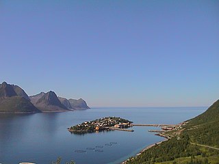
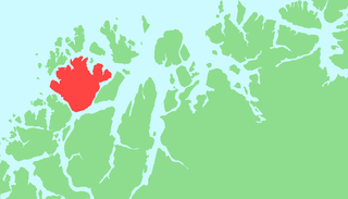
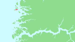
Husøy is a village in Lenvik Municipality in Troms county, Norway. The village covers the entire island of Husøy which is located in the Øyfjorden off the northwest coast of the large island of Senja. The village/island is located about 53 kilometres (33 mi) southwest of the city of Tromsø. The village of Fjordgård sits about 4 kilometres (2.5 mi) across the fjord on the island of Senja.
Ringvassøya (Norwegian) or Ráneš (Northern Sami) is a large island in Troms county, Norway. It is divided between the municipalities of Tromsø and Karlsøy. Several islands surround Ringvassøya including Kvaløya to the south; Reinøya and Karlsøya to the east; Vannøya, Helgøya, and Nordkvaløya to the north; and Rebbenesøya to the north west. The island is connected to the neighboring island by the Kvalsund Tunnel on the south shore of the island.

Brandsøy (Brandsoy) is a village in the municipality of Flora in Sogn og Fjordane county, Norway. It is located on both sides of small strait that separates the east end of the island of Brandsøya and the mainland. The village sits along the Norwegian National Road 5 highway, about 6.9 kilometres (4.3 mi) east of the town of Florø and about 10 kilometres (6.2 mi) west of the village of Grov. The 0.4-square-kilometre (99-acre) village has a population (2013) of 420, giving the village a population density of 1,337 inhabitants per square kilometre (3,460/sq mi).

Kilsund is a village in Arendal municipality in Aust-Agder county, Norway. The village is located on the island of Tverrdalsøya, although the village has grown over the bridge onto the nearby island of Flostaøya a short distance to the south. The village lies about 6.5 kilometres (4.0 mi) northeast of the village of Strengereid, about 10 kilometres (6.2 mi) northeast of the village of Eydehavn, about 16 kilometres (9.9 mi) northeast of the town of Arendal, and about 8 kilometres (5.0 mi) south of the town of Tvedestrand. Kilsund has two small villages located just to the north and east: Staubø and Holmsund.

Dingevatn or Dingevatnet is the 18th deepest lake in Norway, reaching a maximum depth of 220 metres (720 ft). It is located in the municipality of Gulen in Sogn og Fjordane county. The 2.84-square-kilometre (1.10 sq mi) lake is located just east of the village of Dingja, about 1 kilometre (0.62 mi) southeast of the mouth of the Sognefjorden. The lake lies about 4 kilometres (2.5 mi) north of the municipal center of Eivindvik. The lake flows out into the small Dingjaelva river, which runs past the village of Dingja before emptying into the Sognesjøen strait.
Endestadvatnet is a lake in the municipality of Flora in Sogn og Fjordane county, Norway. The lake is located about 8 kilometres (5.0 mi) east of the village of Eikefjord and 5 kilometres (3.1 mi) west of the lake Emhjellevatnet in neighboring Gloppen municipality.

Alsvåg is a village in the municipality of Øksnes in Nordland county, Norway. It is located on the western bank of the Gavlfjorden on the island of Langøya and about 8 kilometres (5.0 mi) east of the municipal centre of Myre. Alsvåg Church is located in this village.

Raudeberg is a village in Vågsøy Municipality in Sogn og Fjordane county, Norway. It is located on the east side of the island of Vågsøy. The villages of Refvika, Vedvika, and Langeneset are located a few kilometers to the north, and the town of Måløy is about 6 kilometres (3.7 mi) to the south. The island of Silda is located about 2 kilometres (1.2 mi) northeast of the village of Raudeberg. Nord-Vågsøy Church is located on the eastern edge of the village, right along the coast.
Silda is an island in Vågsøy Municipality in Sogn og Fjordane county, Norway. The 1.1-square-kilometre (0.42 sq mi) island is located 2 kilometres (1.2 mi) northeast of the large island of Vågsøy in the Sildagapet bay and about 2.5 kilometres (1.6 mi) west of the island of Barmøya. Silda sits about 2 kilometres (1.2 mi) east of the small village of Langenes and about 3 kilometres (1.9 mi) northeast of Raudeberg, both on the island of Vågsøy. This island is the site of the 1810 Battle of Silda. In 2001, there were 38 inhabitants on the island, which is only accessible by boat.

Dalsfjorden is a fjord in Sogn og Fjordane county, Norway. It is located in the municipalities of Askvoll, Fjaler, and Gaular. It is one of the two main fjords that comprise the Sunnfjord region of the county. The fjord is about 40 kilometres (25 mi) long and it is generally about 0.5 to 1 kilometre wide.

Bremangerlandet is an island in Bremanger Municipality in the traditional district of Nordfjord in Sogn og Fjordane county, Norway. The 153-square-kilometre (59 sq mi) island is the largest island in the county. The highest point on the island is the 889-metre (2,917 ft) tall mountain Svartevassegga, however the cliff at Hornelen, located 1 kilometre (0.62 mi) to the east, is more well-known and has an elevation of 860 metres (2,820 ft). The 4-kilometre (2.5 mi) long lake Dalevatnet is located in the central part of the island.

Kjosen is a village in Tromsø Municipality in Troms county, Norway. The village lies on the island of Kvaløya, about 13 kilometres (8.1 mi) west of the city of Tromsø. It is located at the end of the Kaldfjorden, immediately north of the village of Kaldfjord. The village of Ersfjordbotn lies about 5 kilometres (3.1 mi) to the west and the village of Kvaløysletta lies about 3 kilometres (1.9 mi) to the east.
Reksta is an island in the municipality of Flora in Sogn og Fjordane country, Norway. The 5.8-square-kilometre (2.2 sq mi) island lies about 7 kilometres (4.3 mi) west of the town of Florø in a large group of inhabited islands. Reksta sits about 600 metres (2,000 ft) east of the island of Kinn, about 5 kilometres (3.1 mi) north of the island of Askrova, and about 1.4 kilometres (0.87 mi) south of the island of Skorpa. Most of the inhabitants on Reksta live on the west side in and around the small fishing village of Rognaldsvåg. The population of the island (2001) is 144.
Årset is a village in Ålesund Municipality in Møre og Romsdal county, Norway. The village is located along the Ellingsøyfjorden on the southern shore of the island of Ellingsøya, about 4 kilometres (2.5 mi) east of the village of Myklebost and about 12 kilometres (7.5 mi) west of the village of Tennfjord in Haram Municipality.
Voksa is an island in Sande Municipality in Møre og Romsdal county, Norway. The 1.3-square-kilometre (0.50 sq mi) island lies about 2 kilometres (1.2 mi) east of the island of Kvamsøya, about 1.5 kilometres (0.93 mi) south of the island of Sandsøya, about 3.3 kilometres (2.1 mi) west of the larger island of Gurskøya, and about 1.5 kilometres (0.93 mi) north of the mainland village of Åram in neighboring Vanylven Municipality.
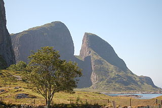
Kinn is an island in Flora Municipality which is in Sogn og Fjordane county, Norway. The island lies about 12 kilometres (7.5 mi) west of the town of Florø. The neighboring island of Reksta lies just 350 metres (1,150 ft) to the east of Kinn, the island of Skorpa lies about 2.5 kilometres (1.6 mi) northeast of Kinn, and the island of Askrova lies about 9 kilometres (5.6 mi) to the southeast. The 2.5-square-kilometre (0.97 sq mi) island is dominated by a large mountain, with all its residents living on the east side. The mountain, Kinnaklova, is a very notable landmark to sailors in the region since it has a deep ravine that cuts through the center of the peak.


