Related Research Articles

The Indus is a transboundary river of Asia and a trans-Himalayan river of South and Central Asia. The 3,180 km (1,980 mi) river rises in mountain springs northeast of Mount Kailash in Western Tibet, flows northwest through the disputed region of Kashmir, bends sharply to the left after the Nanga Parbat massif, and flows south-by-southwest through Pakistan, before emptying into the Arabian Sea near the port city of Karachi.

Sukkur is a city in the Pakistani province of Sindh along the western bank of the Indus River, directly across from the historic city of Rohri. Sukkur is the third largest city in Sindh after Karachi and Hyderabad, and 14th largest city of Pakistan by population. The city was originally founded by the Rai dynasty of Sindh. The modern city was built in the 1840s. New Sukkur was established during the British era alongside the village of Sukkur. Sukkur's hill, along with the hill on the river island of Bukkur, form what is sometimes considered the "Gate of Sindh".
Miani Maluk or Meeanee is a village in Sindh, Pakistan, on the east side of the Indus River. It was the site of the Battle of Miani, which the British won and made Sindh a part of British India.

Sukkur Barrage is a barrage on the River Indus near the city of Sukkur in the Sindh province of Pakistan. The barrage was built during the British Raj from 1923 to 1932 and was named Lloyd Barrage. The Sukkur Barrage, is the pride of Pakistan's irrigation system as it is the largest single irrigation network of its kind in the world. It irrigates from Sukkur district in the north, to Mirpurkhas/Tharparkar and Hyderabad districts in the south of Sindh, almost all parts of the province. It is situated about 500 kilometres northeast of Karachi, 5 kilometres below the railway bridge, or the Sukkur Gorge. The introduction of barrage-controlled irrigation system resulted in more timely water supplies for the existing cultivated areas of Sindh province of Pakistan.
The Kalabagh Dam is a proposed hydroelectric dam on the Indus River at Kalabagh in the Mianwali District, Punjab, Pakistan, which has been intensely debated along ethnic and regional lines for over 40 years.

Sukkur District is a district in Sindh Province in Pakistan. It is divided into 5 administrative townships, namely: Sukkur City, New Sukkur, Rohri, Saleh Pat and Pano Aqil. Among them Sukkur City and New Sukkur are urban centres, while Pano Aqil is famous for having one of the largest military cantonments of the country. Rohri is the smallest tehsil of Sukkur District, both in area and population, but it has an important railway junction.Two districts have been split off from the territory of Sukkur: Shikarpur in 1977 and Ghotki in 1993.

Guddu Barrage is a barrage on the Indus River near Kashmore in the Sindh province of Pakistan. President Iskander Mirza laid the foundation-stone of Guddu Barrage on 2 February 1957. The barrage was completed in 1962 at a cost of 474.8 million rupees and inaugurated by Field Marshal Ayub Khan in 1962.
Rohri is a city of Sukkur District, Sindh province, Pakistan. It is located on the east bank of the Indus River, located directly across from Sukkur, the third largest city in Sindh. Rohri town is the administrative headquarters of Rohri Taluka, and tehsil of Sukkur District with which it forms a metropolitan area. Its capture marked the beginning of Muslim rule in South Asia under Muhammad ibn al-Qasim in 711 CE, when it was named Aror.

Head Taunsa Barrage is a barrage on the River Indus in Taunsa district of previously Dera Ghazi Khan District, Punjab province of Pakistan. It is situated 20 kilometres southeast of Taunsa Sharif and Shadan Lund 16 kilometres from district Kot Addu. This barrage controls water flow in the River Indus for irrigation and flood control purposes. Taunsa Barrage was designated a Ramsar site on 22 March 1996.
Bhiria Road is a town in the Naushahro Feroze District of Sindh, Pakistan. Bhiria Road has a population of 24,741, according to the 2017 census, and spans an area of 4.52 square kilometres. It serves as a commercial hub within the district.
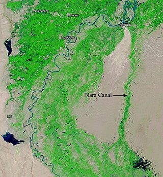
The Nara Canal is a deepened delta channel of the Indus River in Sindh province, Pakistan. It was built as an excavated channel stemming off the left bank of the Indus River to join the course of the old Nara River, a tributary c.q. paleochannel of the Indus which received water from the Ghaggar-Hakra until the Hakra dried-up, early 2nd millennium BCE.
Ayub Bridge, named after Field Marshal Mohammad Ayub Khan, is a railway bridge over the Indus River between Rohri and Sukkur in Sindh province, Pakistan. The bridge is about 806 feet long, 247 feet high and cost Rs21.6 million. It has served the city for 50 years by providing a strong link for rail traffic between Sukkur and Rohri. Before this, Lansdowne Bridge was the railway link between Sukkur and Rohri. The foundation stone of this steel arch bridge was laid on 9 December 1960 and inaugurated by President Muhammad Ayub Khan on 6 May 1962. The consulting engineer was David B. Steinman. The Ayub Bridge became the world's third longest railway arch span and the first railway bridge in the world to be slung on coiled wire rope suspenders.
Rohri Junction Railway Station is located in Rohri, Sukkur district of Sindh province, Pakistan. It is a major railway station on the Pakistan Railways network, serving as the junction between the Karachi–Peshawar Railway Line and Rohri-Chaman Railway Line. The station serves as a stop of all express trains. The station is staffed and has advance and current reservation offices. Food stalls are also located on its platforms. The land of the station is taken on lease for 100 years from Nawab Mir Yakoob Ali Shah.

The M-6 Motorway, or the Sukkur–Hyderabad Motorway, is an under-construction motorway project in Pakistan. It will connect Sukkur to Hyderabad. The 306 km long M-6 motorway is the only missing vital link of North to South connectivity, i.e. from Karachi to Peshawar. The motorway will cost approximately $1.7 billion to build. The M-6 will be a six-lane motorway with a design speed of 120 km/hour, 89 bridges, 15 interchanges and 243 underpasses.

Nai Gaj Dam is an embankment dam currently under construction on the Gaj River in the gorge area at the edge of Kirthar Mountains range at about 65 kilometres (40 mi) north-west of Dadu city in Dadu District, Sindh Province of Pakistan. When complete, its power station will have a 4.2 MW installed capacity. Consultant supervision by Techno Consult International (TCI) from Karachi, Pakistan.
Thari Mirwah, or Thari (ٺري), is the capital city of Mirwah Subdivision in Khairpur District, Sindh, Pakistan. Thari weather is hetregenous (diverse) average temperature recorded is 14 - 40 c in winter and summer. Weather conditions allows growing many cereals and vegetable crops.

The Insurgency in Sindh is a low-intensity insurgency waged by Sindhi Nationalists against the government of Pakistan. Sindhi nationalists want to create an independent state called Sindhudesh.
The Nasrat Canal also locally known as Sada Wah, is a major irrigation canal located in the Sindh province of Pakistan. It originates from the Rohri Canal near Sukkur and flows southward for approximately 260 kilometers, irrigating vast agricultural lands in the districts of Sukkur, Khairpur, Naushero, and Shaheed Benazirabad.
References
- ↑ "The Express Tribune". The Express Tribune. Retrieved 2024-08-19.
- ↑ Correspondent, The Newspaper's Staff (2019-05-04). "Tail-end growers demand water". DAWN.COM. Retrieved 2024-08-19.
{{cite web}}:|last=has generic name (help) - ↑ Khan, Mohammad Hussain (2024-06-24). "Irrigation on hold". DAWN.COM. Retrieved 2024-08-19.
- ↑ "Bilawal directs minister to get Rohri Canal breach repaired". www.thenews.com.pk. Retrieved 2024-08-19.
- ↑ "Breach at Rohri Canal near Tando Adam inundates vast area". Dunya News. 2024-08-05. Retrieved 2024-08-19.
- ↑ Khan, Mohammad Hussain (2016-07-04). "Decaying irrigation network". DAWN.COM. Retrieved 2024-08-19.
- ↑ Khan, Mohammad Hussain (2024-01-15). "From lined legacy to modernised channel". DAWN.COM. Retrieved 2024-08-19.