
Carthage was an ancient city in Northern Africa, on the eastern side of the Lake of Tunis in what is now Tunisia. Carthage was one of the most important trading hubs of the Ancient Mediterranean and one of the most affluent cities of the classical world. It became the capital city of the civilisation of Ancient Carthage and later Roman Carthage.

Tunisia, officially the Republic of Tunisia, is the northernmost country in Africa. It is a part of the Maghreb region of North Africa, bordered by Algeria to the west and southwest, Libya to the southeast, and the Mediterranean Sea to the north and east. Tunisia also shares maritime borders with Italy through the islands of Sicily and Sardinia to the north and Malta to the east. It features the archaeological sites of Carthage dating back to the 9th century BC, as well as the Great Mosque of Kairouan. Known for its ancient architecture, souks, and blue coasts, it covers 163,610 km2 (63,170 sq mi), and has a population of 12.1 million. It contains the eastern end of the Atlas Mountains and the northern reaches of the Sahara desert; much of its remaining territory is arable land. Its 1,300 km (810 mi) of coastline includes the African conjunction of the western and eastern parts of the Mediterranean Basin. Tunisia is home to Africa's northernmost point, Cape Angela. Located on the northeastern coast, Tunis is the capital and largest city of the country, which is itself named after Tunis. The official language of Tunisia is Modern Standard Arabic. The vast majority of Tunisia's population is Arab and Muslim. Vernacular Tunisian Arabic is the most spoken, and French also serves as an administrative and educational language in some contexts, but it has no official status.

Operation Torch was an Allied invasion of French North Africa during the Second World War. Torch was a compromise operation that met the British objective of securing victory in North Africa while allowing American armed forces the opportunity to begin their fight against Nazi Germany and Fascist Italy on a limited scale. It was the first mass involvement of US troops in the European–North African Theatre and saw the first large-scale airborne assault carried out by the United States.

The Battle of Kasserine Pass took place from 18-24 February 1943 at Kasserine Pass, a 2-mile-wide (3.2 km) gap in the Grand Dorsal chain of the Atlas Mountains in west central Tunisia. It was a part of the Tunisian campaign of World War II.
el-Djerid, also al-Jarīd, or more precisely the South Western Tunisia Region is a semi-desert natural region comprising three southern Tunisian Governorates, Gafsa, Kebili and Tozeur with adjacent parts of Algeria and Libya.

The Battle of El Guettar took place during the Tunisia Campaign of World War II, fought between elements of the Army Group Africa under General Hans-Jürgen von Arnim, along with Italian First Army under General Giovanni Messe, and U.S. II Corps under Lieutenant General George Patton in south-central Tunisia. It was the first battle in which U.S. forces were able to defeat the experienced German tank units, but the followup to the battle was inconclusive.

Utica was an ancient Phoenician and Carthaginian city located near the outflow of the Medjerda River into the Mediterranean, between Carthage in the south and Hippo Diarrhytus in the north. It is traditionally considered to be the first colony to have been founded by the Phoenicians in North Africa. After Carthage's loss to Rome in the Punic Wars, Utica was an important Roman colony for seven centuries.

Light cavalry comprised lightly armed and armored cavalry troops mounted on fast horses, as opposed to heavy cavalry, where the mounted riders were heavily armored. The purpose of light cavalry was primarily raiding, reconnaissance, screening, skirmishing, patrolling, and tactical communications. Prior to the 17th century they were usually armed with swords, spears, javelins, or bows, and later on with sabres, pistols, shotguns, or carbines.

Gafsa is the capital of Gafsa Governorate of Tunisia. With a population of 111,170, Gafsa is the ninth-largest Tunisian city and it is 335 kilometers from the capital Tunis.

The Battle of the Mareth Line or the Battle of Mareth was an attack in the Second World War by the British Eighth Army in Tunisia, against the Mareth Line held by the Italo-German 1st Army. It was the first big operation by the Eighth Army since the Second Battle of El Alamein 4+1⁄2 months previously. On 19 March 1943, Operation Pugilist, the first British attack, established a bridgehead but a break-out attempt was defeated by Axis counter-attacks. Pugilist established an alternative route of attack and Operation Supercharge II, an outflanking manoeuvre via the Tebaga Gap was planned. Montgomery reinforced the flanking attack, which from 26 to 31 March, forced the 1st Army to retreat to Wadi Akarit, another 40 mi (64 km) back in Tunisia.

Thelepte was a city in the Roman province of Byzacena, now in western Tunisia. It is located near the border with Algeria about 5 km north from the modern town of Fériana and 30 km south-west of the provincial capital Kasserine.

Approximately 100 years after the destruction of Punic Carthage in 146 BC, a new city of the same name was built on the same land by the Romans in the period from 49 to 44 BC. By the 3rd century, Carthage had developed into one of the largest cities of the Roman Empire, with a population of several hundred thousand. It was the center of the Roman province of Africa, which was a major breadbasket of the empire. Carthage briefly became the capital of a usurper, Domitius Alexander, in 308–311. Conquered by the Vandals in 439, Carthage served as the capital of the Vandal Kingdom for a century. Re-conquered by the Eastern Roman Empire in 533–534, it continued to serve as an Eastern Roman regional center, as the seat of the praetorian prefecture of Africa. The city was sacked and destroyed by Umayyad Arab forces after the Battle of Carthage in 698 to prevent it from being reconquered by the Byzantine Empire. A fortress on the site was garrisoned by Muslim forces until the Hafsid period, when it was captured by Crusaders during the Eighth Crusade. After the withdrawal of the Crusaders, the Hafsids decided to destroy the fortress to prevent any future use by a hostile power. Roman Carthage was used as a source of building materials for Kairouan and Tunis in the 8th century.
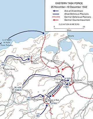
The Run for Tunis was part of the Tunisia Campaign which took place during November and December 1942 during the Second World War. Once French opposition to the Allied Operation Torch landings had ceased in mid-November, the Allies made a rapid advance by a division-sized force east from Algeria, to capture Tunis and forestall an Axis build up in Tunisia and narrowly failed. Some Allied troops were fewer than 20 miles (32 km) short of Tunis by late November but the defenders counter-attacked and pushed them back nearly 20 miles (32 km), to positions which had stabilised by the end of the year.
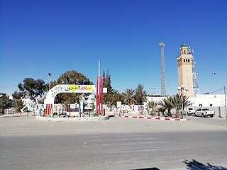
Métlaoui is a town and commune in the Gafsa Governorate, Tunisia. In 2014 it had a population of 38,634.
Dahmani, formerly Abbah Quşūr, is a town and commune in the Kef Governorate, Tunisia. As of 2004 it had a population of 14,061. It is located at 625 meters above sea level, 225 kilometers southwest of Tunis.

The area of North Africa which has been known as Libya since 1911 was under Roman domination between 146 BC and 672 AD. The Latin name Libya at the time referred to the continent of Africa in general. What is now coastal Libya was known as Tripolitania and Pentapolis, divided between the Africa province in the west, and Crete and Cyrenaica in the east. In 296 AD, the Emperor Diocletian separated the administration of Crete from Cyrenaica and in the latter formed the new provinces of "Upper Libya" and "Lower Libya", using the term Libya as a political state for the first time in history.

Pupput, also spelled "Putput", "Pudput", "Pulpud" and "Pulpite" in Latin, sometimes located in Souk el-Obiod ou Souk el-Abiod, is a Colonia in the Roman province of Africa which has been equated with an archaeological site in modern Tunisia. It is situated on the coast near the town of Hammamet, between the two wadis of Temad to the north and Moussa to the south. Much of the Pupput is buried under modern holiday developments which have been built over the major part of the site.

Limisa is a town and archaeological site in Kairouan Governorate, Tunisia. It is located 50 kilometers west of kairouan. The town was a Roman Catholic diocese.

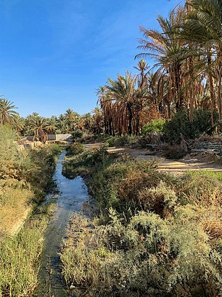
Gafsa Oases are date palm oases at Gafsa in southwestern Tunisia, near the northern edge of the Sahara Desert. The Gafsa Oases were known to the ancient Romans and cover approximately 700 hectares. The oases were designated a Globally Important Agricultural Heritage System in 2011. The individual oases are called Sakdoud, Ksar, Lela, Gafsa and El Guettar.

Capsa was a Roman colonia located in the south of modern-day Tunisia. Before Roman times Capsa was a center of the Capsian culture.

