Ron Heath

Last updated
Ronald Allan Heath
Nationality New Zealand
Alma materBSc, University of Canterbury
PhD Victoria University of Wellington
Scientific career
Fields Physical oceanography
Institutions N.Z. Oceanographic Institute, University of Otago

Ronald Allan Heath, is a retired oceanographer and university administrator. His research focus was on the physical oceanography of the oceans around New Zealand. [1]

Contents

Education and career

Heath was born in Motueka in 1944. He attended the University of Canterbury where he gained a B.Sc. in physics and later was awarded a PhD by the Victoria University of Wellington. He joined the N.Z. Oceanographic Institute (NZOI) in 1967, rising to Deputy Director in 1982 and then as Director in 1986 when Des Hurley stepped down from the role. [1] Through various name changes Heath remained as Director of DSIR Marine and Freshwater until the point at which it was disestablished and became part of the new Crown Research Institute NIWA. The NZOI remained a distinct group within NIWA for a number of years. [1] In 1994 Heath left NIWA to become the Assistance Vice-Chancellor (Science) at the University of Otago in Dunedin. Heath retired in 2004, to be replaced by Vernon Squire. [2]

Cook Strait and the upper east coast of New Zealand's South Island. Heath quantified the tidal mechanics of the region. Making Waves in Marlborough Sounds.jpeg
Cook Strait and the upper east coast of New Zealand's South Island. Heath quantified the tidal mechanics of the region.

He had significant involvement in oceanographic organisations including presidency of the N.Z. Marine Sciences Association, membership of the IUGG Tsunami Committee and the SCOR Working Group on General Circulation of the Southern Ocean. [1]

Science and impact

Heath was the leading N.Z. physical oceanographer of his era, writing papers on most aspects of the region's physical oceanography. [3] Heath provided a summary of this work at the time in a major review that sought to "review the physical oceanography of the seas around New Zealand as known up to 1982 and includes: deep-ocean water characteristics and mean flow; fronts, tides, and coastal and continental shelf oceanography; and waves and tsunamis". [4] The paper concluded with the forward-looking perspective on the future advances possible with the, at the time new, satellite sensing capability.

He was notable for developing understanding of a number of key aspects of the oceans around New Zealand in a time when ocean data were difficult to obtain and numerical simulation tools were embryonic. He developed early understanding of the tidal mechanics of Cook Strait/Te Moana-o-Raukawa and the presence of a virtual amphidrome. [5] He also calculated an early estimate of the net flux through Cook Strait. [6] This estimate wasn't superseded until 2021 when a new computer model estimate was published. [7] Heath's Cook Strait work was notable also for its use of the tracks of swimmers crossing the 25 km-wide Cook Strait as a form of tracer. [8]

Heath published some of the early work on ocean circulation in Southern McMurdo Sound, Antarctica. [9] This work was notable in that they used explosives to access the ocean and then used various drifting vane approaches to quantifying ocean currents. This early work refers to the McMurdo Ice Shelf as "fast ice" something that is now known to be incorrect.

McMurdo Sound (LIMA image) and the region that Heath sampled Dry Valleys and McMurdo Sound - LIMA image.png
McMurdo Sound (LIMA image) and the region that Heath sampled

Among the many regions around New Zealand that Heath published on was the circulation in and around Tasman and Golden Bays. This double-bay opens out to Greater Cook Strait. Heath used drift cards to examine how the wind influenced the shallow bays. [10] This work remained as the only systematic oceanographic study in the region until the work nearly 50 years later from Chiswell who used modern oceanographic instruments. [11]

STS076-713-039 - STS-076 - Mir Space Station views of Tasman and Golden Bay, a region surveyed by Heath in the early 1970s STS076-713-039 - STS-076 - Mir Space Station views after undocking and flyaround by shuttle Atlantis - DPLA - d5058719a930231507cd9c4781c5c66d.jpg
STS076-713-039 - STS-076 - Mir Space Station views of Tasman and Golden Bay, a region surveyed by Heath in the early 1970s

He also led biophysical oceanographic studies, unusual for the time. These included collaboration with Janet Grieve on phytoplankton production over the Campbell Plateau, the large shallow region to the south east of New Zealand that forms part of the Zealandia submerged continent. [12]

Related Research Articles

Cook Strait separates the North and South Islands of New Zealand. The strait connects the Tasman Sea on the northwest with the South Pacific Ocean on the southeast. It is 22 kilometres (14 mi) wide at its narrowest point, and is considered one of the most dangerous and unpredictable waters in the world. Regular ferry services run across the strait between Picton in the Marlborough Sounds and Wellington.

<span class="mw-page-title-main">Continental shelf</span> Coastal and oceanic landform

A continental shelf is a portion of a continent that is submerged under an area of relatively shallow water, known as a shelf sea. Much of these shelves were exposed by drops in sea level during glacial periods. The shelf surrounding an island is known as an insular shelf.

<span class="mw-page-title-main">Spring bloom</span> Strong increase in phytoplankton abundance that typically occurs in the early spring

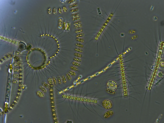
The spring bloom is a strong increase in phytoplankton abundance that typically occurs in the early spring and lasts until late spring or early summer. This seasonal event is characteristic of temperate North Atlantic, sub-polar, and coastal waters. Phytoplankton blooms occur when growth exceeds losses, however there is no universally accepted definition of the magnitude of change or the threshold of abundance that constitutes a bloom. The magnitude, spatial extent and duration of a bloom depends on a variety of abiotic and biotic factors. Abiotic factors include light availability, nutrients, temperature, and physical processes that influence light availability, and biotic factors include grazing, viral lysis, and phytoplankton physiology. The factors that lead to bloom initiation are still actively debated.

<span class="mw-page-title-main">Pelorus Sound</span> Body of water

Pelorus Sound / Te Hoiere is the largest of the sounds which make up the Marlborough Sounds at the north of the South Island, New Zealand. The Marlborough Sounds is a system of drowned river valleys, which were formed after the last ice age around 10,000 years ago. Pelorus Sound has a main channel which winds south from Cook Strait for about 55 kilometres (34 mi), between steeply sloped wooded hills, until it reached its head close to Havelock town. Pelorus has several major arms, notably Tennyson Inlet, Tawhitinui Reach, Kenepuru Sound and the Crail/Clova/Beatrix Bay complex. Its shoreline runs for 380 kilometres (240 mi).

A pycnocline is the cline or layer where the density gradient is greatest within a body of water. An ocean current is generated by the forces such as breaking waves, temperature and salinity differences, wind, Coriolis effect, and tides caused by the gravitational pull of celestial bodies. In addition, the physical properties in a pycnocline driven by density gradients also affect the flows and vertical profiles in the ocean. These changes can be connected to the transport of heat, salt, and nutrients through the ocean, and the pycnocline diffusion controls upwelling.

<span class="mw-page-title-main">Vitiaz Strait</span> Strait in Papua New Guinea

Vitiaz Strait is a strait between New Britain and the Huon Peninsula, northern New Guinea.

<span class="mw-page-title-main">East Australian Current</span> Currents of the Pacific Ocean

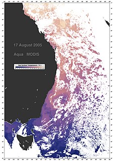
The East Australian Current (EAC) is a warm, southward, western boundary current that is formed from the South Equatorial Current (SEC) crossing the Coral Sea and reaching the eastern coast of Australia. At around 15° S near the Australian coast the SEC divides forming the southward flow of the EAC. It is the largest ocean current close to the shores of Australia.

<span class="mw-page-title-main">Critical depth</span> Hypothesized depth at which phytoplankton growth is matched by losses

In biological oceanography, critical depth is defined as a hypothetical surface mixing depth where phytoplankton growth is precisely matched by losses of phytoplankton biomass within the depth interval. This concept is useful for understanding the initiation of phytoplankton blooms.

<span class="mw-page-title-main">National Institute of Water and Atmospheric Research</span> New Zealand national research institute

The National Institute of Water and Atmospheric Research or NIWA, is a Crown Research Institute of New Zealand. Established in 1992, NIWA conducts research across a broad range of disciplines in the environmental sciences. It also maintains nationally and, in some cases, internationally important environmental monitoring networks, databases, and collections.

<span class="mw-page-title-main">David McNiven Garner</span> New Zealand physicist and oceanographer (1928–2016)

David McNiven Garner was notable as a published research physicist, with a focus in physical oceanography and ocean circulation.

The following outline is provided as an overview of and introduction to Oceanography.

Aquatic science is the study of the various bodies of water that make up our planet including oceanic and freshwater environments. Aquatic scientists study the movement of water, the chemistry of water, aquatic organisms, aquatic ecosystems, the movement of materials in and out of aquatic ecosystems, and the use of water by humans, among other things. Aquatic scientists examine current processes as well as historic processes, and the water bodies that they study can range from tiny areas measured in millimeters to full oceans. Moreover, aquatic scientists work in Interdisciplinary groups. For example, a physical oceanographer might work with a biological oceanographer to understand how physical processes, such as tropical cyclones or rip currents, affect organisms in the Atlantic Ocean. Chemists and biologists, on the other hand, might work together to see how the chemical makeup of a certain body of water affects the plants and animals that reside there. Aquatic scientists can work to tackle global problems such as global oceanic change and local problems, such as trying to understand why a drinking water supply in a certain area is polluted.

<span class="mw-page-title-main">French Pass</span>

French Pass is a narrow and treacherous stretch of water that separates D'Urville Island, at the north end of the South Island of New Zealand, from the mainland coast. At one end is Tasman Bay, and at the other end the outer Pelorus Sound leads out to Cook Strait.

<span class="mw-page-title-main">Ocean power in New Zealand</span>

New Zealand has large ocean energy resources but does not yet generate any power from them. TVNZ reported in 2007 that over 20 wave and tidal power projects are currently under development. However, not a lot of public information is available about these projects. The Aotearoa Wave and Tidal Energy Association was established in 2006 to "promote the uptake of marine energy in New Zealand". According to their 10 February 2008 newsletter, they have 59 members. However, the association doesn't list its members.

<span class="mw-page-title-main">Haskell Strait, Antarctica</span>

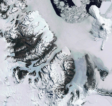
Haskell Strait refers to the ocean passage in southern McMurdo Sound, running between Cape Armitage, Ross Island and Cape Spencer-Smith, White Island, Antarctica. Oceanographically, it separates McMurdo Sound from the ocean basin beneath the Ross Ice Shelf. The Strait itself is around 25 km wide and in places over 900 m deep. Currents of nearly half a knot have been measured in the Strait, although typical flows are lower. It is mostly covered by the ice of the McMurdo Ice Shelf and fast ice in southern McMurdo Sound. On rare occasions sea-ice breakout exposes the north-west corner of the Strait which becomes navigable and vessels can actually moor off Scott Base.

Keith Andrew Hunter was a New Zealand ocean chemist who was a professor of chemistry and pro-vice-chancellor of sciences, at the University of Otago.

The Tasman Front is a relatively warm water east-flowing surface current and thermal boundary that separates the Coral Sea to the north and the Tasman Sea to the south.

<span class="mw-page-title-main">Natalie Robinson</span> Antarctic, climate and atmospheric researcher

Natalie Robinson, an Antarctic researcher, is based at the National Institute of Water and Atmospheric Research in New Zealand. She led the final two K131 Science Events on the sea ice of McMurdo Sound, Antarctica.

<span class="mw-page-title-main">Janet Grieve</span> New Zealand carcinologist

Janet Mary Grieve, also known as Janet Bradford-Grieve and Janet Bradford, is a New Zealand biological oceanographer, born in 1940. She is researcher emerita at the National Institute of Water and Atmospheric Research in Wellington. She has researched extensively on marine taxonomy and biological productivity. She was president of both the New Zealand Association of Scientists (1998–2000) and the World Association of Copepodologists (2008–11).

<span class="mw-page-title-main">N.Z. Oceanographic Institute</span> New Zealand Oceanographic service

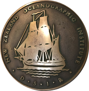
The New Zealand Oceanographic Institute (NZOI) was a department within the Division of Marine and Freshwater Science, as part of the Department of Scientific and Industrial Research.

References

  1. 1 2 3 4 Thompson R-MC. (compiler). 1994. "The First Forty Years", New Zealand Oceanographic Institute: Lives and Times 1954–1994, 40th Jubilee Committee 1994.
  2. 2003 Univ. Otago Annual Report, www.otago.ac.nz/otago000778.pdf
  3. Stevens, C.L., O’Callaghan, J.M., Chiswell, S.M. and Hadfield, M.G., 2021. Physical oceanography of New Zealand/Aotearoa shelf seas–a review. New Zealand Journal of Marine and Freshwater Research, 55(1), pp.6-45.
  4. Heath, R.A., 1985. A review of the physical oceanography of the seas around New Zealand—1982. New Zealand journal of marine and freshwater research, 19(1), pp.79-124.
  5. Heath, R.A., 1978. Semi‐diurnal tides in Cook Strait. New Zealand Journal of Marine and Freshwater Research, 12(2), pp.87-97.
  6. Heath, R.A., 1986. In which direction is the mean flow through Cook Strait, New Zealand—evidence of 1 to 4 week variability?. New Zealand journal of marine and freshwater research, 20(1), pp.119-137.
  7. Hadfield, M.G. and Stevens, C.L., 2021. A modelling synthesis of the volume flux through Cook Strait. New Zealand Journal of Marine and Freshwater Research, 55(1), pp.65-93.
  8. Heath, R.A., 1980. Current measurements derived from trajectories of Cook Strait swimmers. New Zealand Journal of Marine and Freshwater Research, 14(2), pp.183-188.
  9. Heath, R.A., 1971. Circulation and hydrology under the seasonal ice in McMurdo Sound, Antarctica. New Zealand Journal of marine and freshwater research, 5(3-4), pp.497-515.
  10. Heath, R.A., 1973. Meteorological effects on the surface circulation and hydrology of Tasman Bay, New Zealand. New Zealand journal of marine and freshwater research, 7(1-2), pp.111-123.
  11. Chiswell, S.M., Stevens, C.L., Macdonald, H.S., Grant, B.S. and Price, O., 2021. Circulation in Tasman-Golden bays and Greater Cook Strait, New Zealand. New Zealand Journal of Marine and Freshwater Research, 55(1), pp.223-248.
  12. Heath, R.A. and Bradford, J.M., 1980. Factors affecting phytoplankton production over the Campbell Plateau, New Zealand. Journal of Plankton Research, 2(2), pp.169-181.