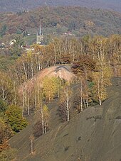
Schœneck is a commune in the Moselle department in Grand Est in north-eastern France. It is located in the Warndt Basin, and is a border town with Germany, wedged between Stiring-Wendel and Saarbrücken.

The Arthur de Buyer Coal Mine, or coal mine #11, was one of the major Ronchamp coal mines, which is in the area of the commune of Magny-Danigon in the French region of Franche-Comté. Digging started in 1894 in an attempt to ensure the future of the company, which was in a difficult position at that time. The project was directed by Leon Poussigue, director of the company since 1891. He was responsible for organizing the excavation, designing buildings and installing each machine. The seat is named as a tribute to Arthur de Buyer, the president since 1876. He retired during the commissioning activity of the mine.
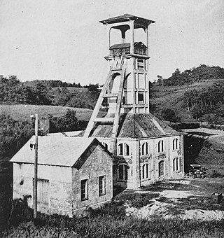
The Sainte Marie Coal Mine is one of the major Ronchamp coal mines, located in Bourlémont, in eastern France. It was worked intermittently between 1866 and 1958, then finally closed. The concrete headframe was reinforced in 1924 by Charles Tournay. This Liège engineer and architect specialized in constructing concrete headframes. On 29 March 2001, the headframe was listed as a French national monument historique.

The Vosges and Jura coal mining basins are an area of France located between two mountain ranges, that has been shaped by four centuries of coal extraction from the 16th century to the 20th century. It includes four coal basins in three geographic locations.
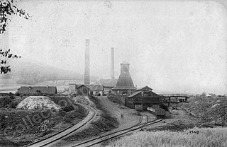
The Notre-Dame Pit was one of the principal mine shafts of the Ronchamp Mining Company, located in North-Eastern France in the hamlet of Éboulet, the commune of Champagney, and the department of Haute-Saône. The pit was created by a rival company, The Forge Masters, which had owned the hamlet of Éboulet's mines since 1851, fifteen years before the Ronchamp Mining Company acquired them. As its supply of coal dwindled, the mine was converted into a water well used for pumping water used in the mining process to several other nearby mines. The pit was plugged in 1958, when all the coal mines formerly owned by Ronchamp were closed by the government utility, Électricité de France.

The Chanois coal mine is one of the main shafts of the Ronchamp coal mines, in the French commune of Ronchamp, within the Haute-Saône department, belonging to the Bourgogne-Franche-Comté region. It was the center of Ronchamp's coal mining operations from the late 19th century until the mines closed in 1958. It was therefore chosen as the site for the coal mine's ancillary facilities, including a coal preparation plant, a coking plant, and a power station. It succeeded the Saint Joseph shaft in 1895 and ceased mining in 1951.

The Sainte-Barbe Coal Mine is a former shaft of the Ronchamp coal mines located near the Champagney ballast pits, in eastern France. The shaft was excavated in 1854, and mined for coal from 1860 to 1872. It was used to ventilate the Sainte-Pauline shaft from 1869 to 1884, before being backfilled. Its longevity and productivity were less than those of the company's main extraction shafts.

The Saint-Louis Coal Mine is one of the main shafts at the Ronchamp coal mines in the Bourgogne-Franche-Comté region of France. Located in the hamlet of La Houillère, in the commune of Champagney, it was the first real mine shaft to be dug in the Ronchamp coalfield. It was the most productive coal mine in the Ronchamp coalfield during the first half of the 19th century. On April 10, 1824, this shaft also experienced the first firedamp explosion in the coalfield, which killed twenty people and injured sixteen others. Later, on May 31, 1830, a second, even more deadly, firedamp explosion killed twenty-eight people. The pit was finally abandoned and backfilled in 1842. A mining estate was built next to the pit in the 1850s.

The Saint-Joseph Coal Mine is one of the main shafts of the Ronchamp coal mine, in the Ronchamp commune, within the French region of Bourgogne-Franche-Comté. It was one of the most productive coal mines in the Ronchamp coalfield during the second half of the 19th century. Throughout this period, it was the center of activity for the mining company, with the installation of a coking plant and a coal-washing plant, before being replaced by the Chanois shaft. The Saint Joseph shaft was hit by several disasters. On August 10, 1859, a firedamp explosion killed twenty-nine people. On May 8, 1860, another explosion destroyed the underground tunnels and the roof of the surface recette building.

The hamlet of La Houillère is located in the French communes of Ronchamp and Champagney, in the heart of the mining region, in the Haute-Saône département of the Bourgogne-Franche-Comté region.

The Etançon mine is one of the main mines of the Ronchamp coal mines, in the commune of Ronchamp, in the Burgundy-Franche-Comté region of France. It is the only mine in the coalfield dug in the 20th century, and also the only one dug by Électricité de France. It operated from 1950 to 1958, when the outcrops were brought back into production. By extending mining for a further ten years, it made it easier for miners to retire.
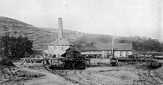
The Saint-Charles shaft is one of the main collieries of the Ronchamp coal mine. It is located in Ronchamp, Haute-Saône, in eastern France. In the second half of the nineteenth century, this shaft made it possible to mine large coal seams, contributing to the company's golden age.

On 10 April 1824 an explosion occurred in the Saint-Louis coal mine in Champagney, France. The explosion, called the first disaster at the Saint-Louis coal mine, was the first firedamp explosion in the Ronchamp and Champagney coalfields (Haute-Saône) and one of the first in France. It was also one of the deadliest in the history of the Ronchamp coal mines, killing twenty and injuring sixteen. The disaster had a profound impact on the local population and national opinion, calling into question the safety of firedamp mines and the conditions of ventilation.

The Ronchamp coal mines adit is a large drainage channel with brick walls. It was used to drain the mine water between 1783 and 1840. It has a section of 70 × 50 cm and is 1.3 km long. It was supplied by the Henri IV shaft and the Clocher adit.

The mining basin of Ronchamp and Champagney is a territory located in the department of Haute-Saône and the French region of Bourgogne-Franche-Comté; economically, socially, environmentally, and culturally marked by the intensive exploitation of coal in its subsoil between the 18th and 20th centuries. It consists of the three main municipalities of Ronchamp, Champagney, and Magny-Danigon as well as several hamlets and other neighboring villages.
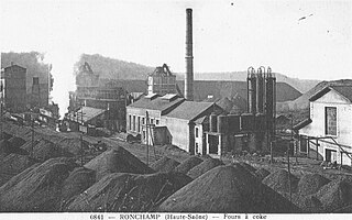
The cokerie-lavoir du Chanois is an industrial complex of the Ronchamp collieries that combines coal sorting-screening, washing, and preparation: facilities on a site adjacent to the Chanois pit, in Magny-Danigon, Haute-Saône, in the French region of Bourgogne-Franche-Comté.

The Magny shaft is one of the main shafts of the Ronchamp colliery, located in the commune of Magny-Danigon, in the French department of Haute-Saône and the Bourgogne-Franche-Comté region. With a depth of 694 meters, it was the deepest mine shaft in France when it was commissioned in 1878. It is also the Ronchamp shaft with the longest period of operation, at 80 years. This long period of mining was interspersed with several periods of service, the longest lasting more than a decade between the wars. On September 1, 1879, the colliery suffered a firedamp explosion that killed sixteen people. From this shaft, the last coal car in the coalfield was hauled up on Saturday, May 3, 1958.

The Ronchamp colliery shafts are a series of collieries undertaken by the various mining companies in the Ronchamp coalfield between the early 19th and mid-20th centuries at Ronchamp, Champagney, and Magny-Danigon, in the Haute-Saône département of France.

The Ronchamp coal mine railway is a former industrial rail track serving the Ronchamp coal mines. It is located in the French department of Haute-Saône and the region of Bourgogne-Franche-Comté. The link between the mines' local rail network and the line from Paris-Est to Mulhouse-Ville runs near the Ronchamp station via a particular station connected to the main line.

The Haute-Saône Keuperian coalfield constitutes the coal basins from the Vosges and Jura. From a geological perspective, it represents the most recent of the two coal deposits in Haute-Saône. Coal mining in the region commenced in the late 16th century and continued until the mid-20th century, with operations occurring in the southeastern portion of Haute-Saône, as well as in the northern regions of Doubs and Jura in eastern France. The coal extracted from this field was characterized by high sulfur content, making it a low-grade resource. This quality limited its use in most applications; however, it was effectively used as fuel in boilers for evaporating brine at local saltworks. Additionally, other resources such as rock salt, pyrite, and gypsum were also extracted from the same geological layer.

