Rookery House

Last updated

Rookery House
Rookery House, Erdington - geograph.org.uk - 2344511.jpg
The building in 2011
LocationWilberforce Way, Erdington
Coordinates 52°31′03″N1°50′05″W / 52.5175°N 1.8348°W / 52.5175; -1.8348
Built1727
Architectural style(s) Neoclassical style
Listed Building – Grade II
Official nameHouse in Rookery Park, Rookery Park, Handsworth
Designated7 July 1982
Reference no.1076201
West Midlands UK location map.svg
Red pog.svg
Shown in West Midlands

Rookery House, formerly Erdington Town Hall and, before that, Birches Green House, is a former municipal building in Wilberforce Way in Erdington, a suburb of Birmingham in England. The house, which started life as a private residence, became the headquarters of Erdington Urban District Council and was then returned to residential use, is a Grade II listed building. [1]

Contents

History

The building was commissioned by Abraham Spooner, an ironmaster who was the proprietor of Bromford Forge and Aston Furnace. [2] The site he selected in Birches Green was occupied by an earlier timber-framed house. [3] Originally known as Birches Green House, the new building was designed in the neoclassical style, built in brick with a stucco finish and was completed in 1727. [4] [5]

Abraham's son, Isaac, who was a banker, inherited the house in 1788, and Isaac's son, Richard, was born there and went on to be a member of parliament. [6] After Abraham's granddaughter, Barbara, married the anti-slavery campaigner, William Wilberforce, in May 1797, the house became their home. [7] The house was remodelled in the early 19th century. [1] The glass manufacturer, Brueton Gibbons, who installed plate glass doors in the house, lived there from 1816 and the pencil-case manufacturer, William Wiley, lived there from 1871. [6]

Following significant population growth, largely associated with residential development, a local board of health was formed in the Aston Parish area in 1869. [8] After the local board of health was succeeded, in that part of the parish, by Erdington Urban District Council in 1894, [9] the new council began using the building as its headquarters. [10] The building remained the local seat of government until the area was annexed by Birmingham City Council in 1911. [11]

The council continued to use the building, latterly as a social services office, until 2008. [7] [12] It subsequently fell into poor repair and the council declared it surplus to requirements. [13] It was sold it to a developer, Cameron Homes, in 2017, [14] and construction work, to convert the building into 15 residential apartments, started in 2019. [15] [16]

Architecture

The three-storey building is constructed of brick, covered in stucco, with a slate roof. It is seven bays wide, with the central section of three bays slightly recessed. There is an off-centre entrance, in a porch formed by Doric order columns supporting an entablature and a cornice. The building is fenestrated by sash windows. There are various extensions, including a two-bay single storey addition to the right of the original building. It has been grade II listed since 1982. [1] [17]

Related Research Articles

<span class="mw-page-title-main">Sutton Coldfield</span> Town in West Midlands, England

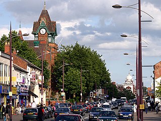
Sutton Coldfield or the Royal Town of Sutton Coldfield, known locally as Sutton ( ), is a town and civil parish in the City of Birmingham, West Midlands, England. The town lies around 8 miles northeast of Birmingham city centre, 9 miles south of Lichfield, 7 miles southwest of Tamworth and 7 miles east of Walsall.

<span class="mw-page-title-main">Warwickshire</span> County of England

Warwickshire is a ceremonial county in the West Midlands of England. It is bordered by Staffordshire and Leicestershire to the north, Northamptonshire to the east, Oxfordshire and Gloucestershire to the south, and Worcestershire and the West Midlands county to the west. The largest settlement is Nuneaton and the county town is Warwick.

<span class="mw-page-title-main">Handsworth, West Midlands</span> Human settlement in England

Handsworth is an inner-city area of Birmingham in the West Midlands, England. Historically in Staffordshire, Handsworth lies just outside Birmingham City Centre and near the town of Smethwick.

<span class="mw-page-title-main">Erdington</span> Suburb of Birmingham, England

Erdington is a suburb and ward of Birmingham in the West Midlands County, England. Historically part of Warwickshire and located 5 miles (8 km) northeast of central Birmingham, bordering Sutton Coldfield. It was also a council constituency, managed by its own district committee. The former council district consisted of the ward of Erdington as well as Tyburn, Stockland Green and Kingstanding, although all of Kingstanding and most of both Tyburn and Stockland Green wards lie outside the historical boundaries of Erdington. Stockland Green was formerly part of Aston, Kingstanding part of Perry Barr and Tyburn partially split between Aston and Hodge Hill. Erdington (ward) was part of the Sutton Coldfield constituency before 1974.

<span class="mw-page-title-main">Government of Birmingham</span>

Birmingham, a city and metropolitan borough in the West Midlands, England, is the second-largest city in the United Kingdom.

Four Oaks is an affluent residential area in Sutton Coldfield, West Midlands, lying along the north and east borders of Sutton Park. Four Oaks is situated approximately 7+12 miles (12.1 km) north of Birmingham City Centre, and is bordered by Sutton Park, Streetly, Mere Green, Little Aston, Roughley and Aldridge. Four Oaks has a population of 21,690 as of 2004, and is part of the Sutton Four Oaks electoral ward.

Tyburn is a ward in Birmingham, England formerly known as Kingsbury.

Stockland Green is an area of Birmingham, England.

<span class="mw-page-title-main">Birmingham Erdington (UK Parliament constituency)</span> Parliamentary constituency in the United Kingdom, 1974 onwards

Birmingham Erdington is a parliamentary constituency in Birmingham, England, represented in the House of Commons of the Parliament of the United Kingdom since 2022 by Paulette Hamilton of the Labour Party.

<span class="mw-page-title-main">Nechells</span> Human settlement in England

Nechells is a district ward in central Birmingham, England, whose population in 2011 was 33,957. It is also a ward within the formal district of Ladywood. Nechells local government ward includes areas, for example parts of Birmingham city centre, which are not part of the historic district of Nechells as such, now often referred to in policy documents as "North Nechells, Bloomsbury and Duddeston".

<span class="mw-page-title-main">Church of SS Peter & Paul, Aston</span> Church

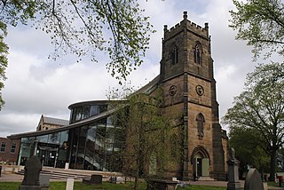
The Parish Church of St Peter and St Paul in Witton Lane, Aston, Birmingham, England, is a parish church in the Church of England.

<span class="mw-page-title-main">Birmingham Baths Committee</span>

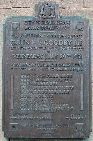
The Birmingham Baths Committee was an organisation responsible for the provision and maintenance of public swimming and bathing facilities. Birmingham City Council funded, constructed and ran bathing facilities throughout the city. The movement to develop baths and wash houses in Britain had its impetus with the rapid urbanisation of the Industrial Revolution, which was felt acutely in Birmingham, one of England's powerhouses.

<span class="mw-page-title-main">Warwickshire County Council</span>

Warwickshire County Council is the county council that governs the non-metropolitan county of Warwickshire in England. Its headquarters are at Shire Hall in the centre of Warwick, the county town. The council's principal functions are county roads and rights of way, social services, education and libraries, but it also provides numerous other local government services in its area.

<span class="mw-page-title-main">Pype Hayes Hall</span> Mansion in Birmingham, England

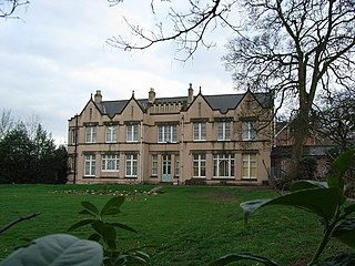
Pype Hayes Hall is a former mansion house in the Pype Hayes area of Erdington, Birmingham, England. The hall's grounds now form Pype Hayes Park. It was formerly in the historic county of Warwickshire before being transferred into the new county of the West Midlands, along with the rest of the city, in 1974. It has grade II listed status.

<span class="mw-page-title-main">Perry Bridge</span> Bridge in Birmingham, England

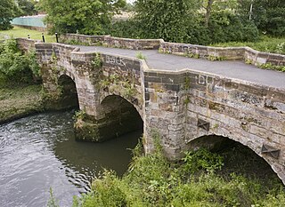
Perry Bridge, also known as the Zig Zag Bridge, is a bridge over the River Tame in Perry Barr, Birmingham, England. Built in 1711, it is a Grade II listed building and a Scheduled monument.

<span class="mw-page-title-main">Pype Hayes</span> Housing estate area in the Erdington district of Birmingham

Pype Hayes is a modern housing estate area and council ward in the east of the Erdington district of Birmingham. It was within the Tyburn ward until 2018. Covering the postcodes of B24 and B76.

<span class="mw-page-title-main">Birmingham city centre</span> City in the West Midlands, England

Birmingham city centre, also known as Central Birmingham, is the central business district of Birmingham, England. The area was historically in Warwickshire. Following the removal of the Inner Ring Road, the city centre is now defined as being the area within the Middle Ring Road. The city centre is undergoing massive redevelopment with the Big City Plan, which means there are now nine emerging districts and the city centre is approximately five times bigger.

<span class="mw-page-title-main">Birches Green</span>

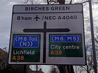
Birches Green is a small area of Tyburn in Birmingham, England, within the parliamentary constitiuency of Erdington. It is located between Gravelly Hill, Erdington and the M6 motorway.

Pype Hayes Park is a park in Birmingham, England. The park is part of the Westminster constituency of Birmingham Erdington and straddles the boundary between the Birmingham City Council wards of Pype Hayes and Erdington. It borders the Pitts Farm estate as well as the Paget and Pype Hayes estates.

<span class="mw-page-title-main">Brookvale Park</span>

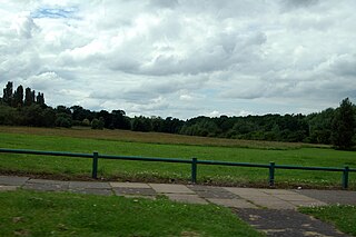
Brookvale Park is located in the Stockland Green Ward of Erdington Constituency in England. The park surrounds Brookvale Park Lake. Within the park there is a bowling green, tennis courts, a children's play area and sailing club. Many local residents and groups take an active interest in the park and the lake.

References

  1. 1 2 3 Historic England. "House in Rookery Park, Rookery Park, Handsworth (1076201)". National Heritage List for England . Retrieved 29 April 2024.
  2. "Elmden Hall, Warwickshire". Lost Heritage. Retrieved 29 April 2024.
  3. Chinn, Carl (2003). Birmingham Bibliography of a City. University of Birmingham Press. p. 18. ISBN   978-1902459240. Rookery House, Erdington (1725–1730 replacing and, to some extent, mimicking an earlier timber-framed hall-house)
  4. "History". Rookery House. Archived from the original on 12 August 2013.
  5. Homer, Andrew (2019). Historic England: Birmingham Unique Images from the Archives of Historic England. Amberley Publishing. ISBN   978-1445691145.
  6. 1 2 Dargue, William. "A History of Birmingham: Erdington" . Retrieved 30 April 2024.
  7. 1 2 Elkes, Neil (6 March 2013). "Erdington's historic Rookery House 'too costly to maintain'". Birmingham Mail. Retrieved 29 April 2024.
  8. "Aston Local History". Birmingham City Council. Retrieved 29 April 2024.
  9. "Erdington UD". Vision of Britain. Retrieved 29 April 2024.
  10. "Erdington Local History". Birmingham City Council. Retrieved 29 April 2024.
  11. Chinn, Carl Steven Alfred (1986). "The Anatomy of a Working Class Neighbourhood: West Sparkbrook 1871 to 1914" (PDF). University of Birmingham. p. 2. Retrieved 29 April 2024.
  12. "Rookery House in Erdington set to be saved". Business Live. 28 October 2008. Retrieved 29 April 2024.
  13. "Historic Rookery House in Erdington to be put up for sale by Birmingham City Council". Business Live. 7 March 2013. Retrieved 29 April 2024.
  14. Elkes, Neil (10 July 2017). "Historic Erdington home with anti-slavery links to be restored as flats". Birmingham Mail. Retrieved 29 April 2024.
  15. "Rookery House". Abode Affiliates. Retrieved 29 April 2024.
  16. "Work starts on £11m historic house project". The Business Desk. 6 March 2019. Retrieved 29 April 2024.
  17. Franklin, J. (2019). "Rookery House, Erdington, Birmingham". Warwick: Archaeology Warwickshire. Retrieved 29 April 2024.