Rosen, Burgas Province

Last updated
Rosen
Росен
Village
Relief Map of Bulgaria.jpg
Red pog.svg
Rosen
Location of Rosen
Coordinates: 42°23′N27°34′E / 42.383°N 27.567°E / 42.383; 27.567
Country Flag of Bulgaria.svg  Bulgaria
Province Burgas Province
Municipality Sozopol
Area
  Total 38.386 km2 (14.821 sq mi)
Elevation 87 m (285 ft)
Population (2013) [1]
  Total 1,470
Time zone EET (UTC+2)
  Summer (DST) EEST (UTC+3)

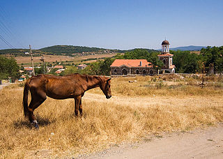
Rosen (Bulgarian : Росен) is a village in Sozopol Municipality, in Burgas Province, in south-eastern Bulgaria. As of 2013 it has 1470 inhabitants. [1]

Bulgarian language South Slavic language

Bulgarian, is an Indo-European language and a member of the Southern branch of the Slavic language family.

Sozopol Municipality Municipality in Burgas, Bulgaria

Sozopol Municipality is located in the southern Bulgarian Black Sea Coast and borders Burgas Municipality and Primorsko Municipality. The coast stretches 51 km of which 17.1 km are excellent beaches. There are many small bays and peninsulas as well as several isles. The climate is favourable for growing different crops such as grapes, apples, peaches, cherries, strawberries and others. Sozopol is the biggest fishing port of the country with two major plants processing fish. Tourism is now the most important industry with more than 50,000 beds in the territory of the municipality. As of 2006 the population is 13,401.

Burgas Province Province in Bulgaria

Burgas Province is a province in southeastern Bulgaria, including southern Bulgarian Black Sea Coast. It is bounded on the south by Turkey. The province is named after its administrative and industrial centre - the city of Burgas - the fourth biggest town in the country. It is the largest province by area, embracing a territory of 7,748.1 km² that is divided into 13 municipalities with a total population, as of December 2009, of 422,319 inhabitants.

The village is situated at the river Rosenska, a tributary to the Ropotamo, at the western foothills of Medni Rid Ridge, which is the north-eastern extreme of the Bosna Ridge in the Strandzha Mountains. [2] It is located at about 22 km south of Burgas and 19 km of the municipal centre Sozopol on the Bulgarian Black Sea coast. [1] [3]
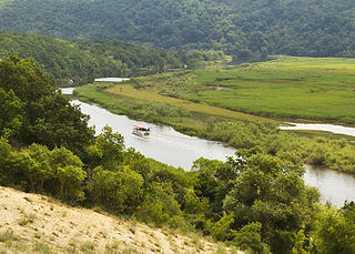
Ropotamo river in southeastern Bulgaria

The Ropotamo is a river in south-eastern Bulgaria. It takes its source from the Bosna Ridge in the Strandzha Mountains, running for 48.5 km to empty into the Black Sea near Cape Saint Demetrius between Dyuni and Primorsko.

Medni Rid mountain

Medni Rid, also known as Bakarlak (Бакърлък) until 1942, is a ridge in south-eastern Bulgaria. It forms the north-eastern extreme of the Bosna Ridge in the Strandzha Mountains. Administratively, it lies in the municipalities of Sozopol and Primorsko, Burgas Province.

Bosna is a ridge in the northern reaches of the Strandzha mountain range situated in the south-eastern part of the Balkan peninsula close to the Black Sea coast. While Strandzha is shared between Bulgaria and Turkey, the Bosna ridge is located entirely within the Bulgarian section of the mountain range. Its highest peak is Papiya. The ridge is approximately 65 km in length and 25 km in width. Most of Bosna falls within the borders of Strandzha Nature Park, the largest protected area in Bulgaria.

The vestiges of the medieval fortress of Krimna are situated at Bakarlaka peak in Medni Rid. In 1328 the Bulgarian emperor Michael Shishman and the Byzantine emperor Andronikos III Palaiologos signed an alliance treaty there. [4] The first school in what is now Sozopol Municipality was established in Rosen in 1830. The Church of Saint George was constructed in 1882. [4]

Michael Shishman of Bulgaria Bulgarian emperor

Michael Asen III, ruled as emperor (tsar) of Bulgaria from 1323 to 1330. The exact year of his birth is unknown but it was between 1280 and 1292. He was the founder of the last ruling dynasty of the Second Bulgarian Empire, the Shishman dynasty. After he was crowned, however, Michael used the name Asen to emphasize his connection with the Asen dynasty, the first one to rule over the Second Empire.

Andronikos III Palaiologos Byzantine emperor/1328-1341

Andronikos III Palaiologos, commonly Latinized as Andronicus III Palaeologus, was Byzantine emperor from 1328 to 1341. Born Andronikos Doukas Angelos Komnenos Palaiologos, he was the son of Michael IX Palaiologos and Rita of Armenia. He was proclaimed co-emperor in his youth, before 1313, and in April 1321 he rebelled in opposition to his grandfather, Andronikos II Palaiologos. He was formally crowned co-emperor in February 1325, before ousting his grandfather outright and becoming sole emperor on 24 May 1328.

Citations

  1. 1 2 3 "Rosen". Guide Bulgaria. Retrieved 28 July 2018.
  2. Geographic Dictionary of Bulgaria 1980 , p. 311
  3. Geographic Dictionary of Bulgaria 1980 , p. 416
  4. 1 2 "Populated places". Official Site of Sozopol Municipality. Retrieved 28 July 2018.

Related Research Articles

Geography of Bulgaria Information about the geographical make-up of Bulgaria, including topology

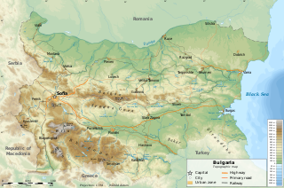
Bulgaria is a country situated in Southeast Europe, bordering Romania to the north, Serbia and North Macedonia to the west, Greece and Turkey to the south, and the Black Sea to the east. The northern border with Romania follows the river Danube until the city of Silistra. The land area of Bulgaria is 110,879 square kilometres (42,811 sq mi), slightly larger than that of Iceland or the U.S. state of Tennessee. Considering its relatively small size, Bulgaria has a great variety of topographical features. Even within small parts of the country, the land may be divided into plains, plateaus, hills, mountains, basins, gorges, and deep river valleys. The geographic center of Bulgaria is located in Uzana.

Transport in Bulgaria

Transport in Bulgaria is dominated by road transport, despite nearly half of all paved roads belonging to the lowest category of roads. As of December 2015, the country had 774 kilometers of highways.

Blagoevgrad Province Province in Bulgaria

Blagoevgrad Province, also known as Pirin Macedonia is a province (oblast) of southwestern Bulgaria. It borders four other Bulgarian provinces to the north and east, to the Greek region of Macedonia to the south, and North Macedonia to the west. The province has 14 municipalities with 12 towns. Its principal city is Blagoevgrad, while other significant towns include Bansko, Gotse Delchev, Melnik, Petrich, Razlog, Sandanski, and Simitli.

Pomorie Place in Burgas, Bulgaria

Pomorie is a town and seaside resort in southeastern Bulgaria, located on a narrow rocky peninsula in Burgas Bay on the southern Bulgarian Black Sea Coast.

Pirin mountain range

The Pirin Mountain are a mountain range in southwestern Bulgaria, with Vihren at an altitude of 2,914 m being the highest peak. One hypothessis is the mountain was named after Perun, the highest god of the Slavic pantheon and the god of thunder and lightning. Another version is that the etymology of the range derives from the Thracian word Perinthos, meaning "Rocky Mountain".

Bulgarian Black Sea Coast geographical object

The Bulgarian Black Sea Coast covers the entire eastern bound of Bulgaria stretching from the Romanian Black Sea resorts in the north to European Turkey in the south, along 378 km of coastline. White and golden sandy beaches occupy approximately 130 km of the 378 km long coast. The region is an important center of tourism during the summer season (May–October), drawing millions of foreign and local tourists alike and constituting one of the country's most popular tourist destinations. Prior to 1989 the Bulgarian Black Sea coast was internationally known as the Red Riviera. Since the fall of the Iron Curtain, however, its nickname has been changed to the Bulgarian Riviera.

Pautalia Glacier glacier in Antarctica

Pautalia Glacier is a small glacier on Burgas Peninsula, Livingston Island in the South Shetland Islands, Antarctica situated northeast of Strandzha Glacier and south of Sopot Ice Piedmont. It is bounded by Petko Voyvoda Peak to the west, Sozopol Gap to the northwest, Kaloyan Nunatak to the north and Shabla Knoll to the east. The glacier extends 700 m in northwest-southeast direction and 1.1 km in southwest-northeast direction, and flows southeastward into Bransfield Strait.

Sarafovo is a neighbourhood of Burgas, largest city in southeast Bulgaria – a regional, tourist and trade center.

Chernomorets Place in Burgas, Bulgaria

Chernomorets is a town on the Black Sea coast of southeastern Bulgaria. Administratively part of Sozopol Municipality, Burgas Province, Chernomorets is a popular seaside resort.

Veselie (village) Village in Burgas Province, Bulgaria

Veselie is a village in Primorsko Municipality, Burgas Province, in southeastern Bulgaria. As of 2013 it has 539 inhabitants.

Atia, Bulgaria Village in Burgas Province, Bulgaria

Atia or Atiya is a village in Sozopol Municipality, Burgas Province, south-eastern Bulgaria. As of 2013 it has 825 inhabitants. It hosts Bulgaria's largest naval base.

Ravadinovo Village in Burgas Province, Bulgaria

Ravadinovo is a village in Sozopol Municipality, in Burgas Province, in southeastern Bulgaria. As of 2013 it has 691 inhabitants.

Porominovo Village in Kyustendil Province, Bulgaria

Porominovo is a village in Kocherinovo Municipality, Kyustendil Province, south-western Bulgaria. As of 2013 it has 453 inhabitants. It is situated at the western foothills of the Rila Mountains on the banks of the Rilska River in the vicinity of the Stob Earth Pyramids.

Melnik Earth Pyramids

The Melnik Earth Pyramids are rock formations, known as hoodoos, situated at the foothills of the Pirin mountain range in south-western Bulgaria. They span an area of 17 km2 near the town of Melnik, Blagoevgrad Province. Reaching a height of up to 100 m these sandstone pyramids are shaped in forms, resembling giant mushrooms, ancient towers and obelisks. They were formed primarily due to erosion from rainfall and bedrock wear. The Melnik Earth Pyramids are a geological phenomenon of global importance and were declared a natural landmark in 1960. The rock formations are home to rich flora and fauna heavily influenced by the Mediterranian climate. They are a tourist destination due to the natural environment of the area, the cultural sights of Melnik and the Rozhen Monastery.

Stob Earth Pyramids

The Stob Earth Pyramids are rock formations, known as hoodoos, situated at the foothills of the Rila mountain range in south-western Bulgaria. They span an area of 0.7 km2 near the village of Stob, Kyustendil Province. The rock formations are up to 12 m high and up to 40 m thick at the base. Their shape is mostly conical to mushroomlike. Some of the columns are topped by flat stones.

Rilska River river in Bulgaria

The Rilska River is a river in south-western Bulgaria, a left tributary of the Struma. The river is 51 km long and drains the western sections of the Rila mountain range.

Momina Klisura (Mesta)

Momina Klisura is a steep valley along the river Mesta in south-western Bulgaria, stretching about 25 km. Administratively, it is situated in the municipalities of Bansko and Gotse Delchev, Blagoevgrad Province. According to the legend, the gorge was named after a maiden, who fought the Ottoman Turks defending the fortress of Momina Kula and plunged into the abyss upon seeing that the stronghold was about to fall.

References

Sofia Capital and largest city of Bulgaria

Sofia is the capital and largest city of Bulgaria. The city is at the foot of Vitosha Mountain in the western part of the country. Being in the centre of the Balkan peninsula, it is midway between the Black Sea and the Adriatic Sea, and closest to the Aegean Sea.