Bulgaria is a country situated in Southeast Europe, bordering Romania to the north, Serbia and North Macedonia to the west, Greece and Turkey to the south, and the Black Sea to the east. The northern border with Romania follows the river Danube until the city of Silistra. The land area of Bulgaria is 110,879 square kilometres (42,811 sq mi), slightly larger than that of Iceland or the U.S. state of Tennessee. Considering its relatively small size, Bulgaria has a great variety of topographical features. Even within small parts of the country, the land may be divided into plains, plateaus, hills, mountains, basins, gorges, and deep river valleys. The geographic center of Bulgaria is located in Uzana.
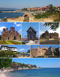
Nesebar is an ancient city and one of the major seaside resorts on the Bulgarian Black Sea Coast, located in Burgas Province. It is the administrative centre of the homonymous Nesebar Municipality. Often referred to as the "Pearl of the Black Sea", Nesebar is a rich city-museum defined by more than three millennia of ever-changing history. The small city exists in two parts separated by a narrow man-made isthmus with the ancient part of the settlement on the peninsula, and the more modern section on the mainland side. The older part bears evidence of occupation by a variety of different civilisations over the course of its existence.

Pomorie is a town and seaside resort in southeastern Bulgaria, located on a narrow rocky peninsula in Burgas Bay on the southern Bulgarian Black Sea Coast.
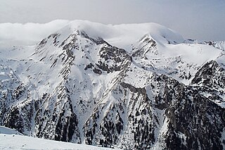
The Pirin Mountain is a mountain range in southwestern Bulgaria, with Vihren at an altitude of 2,914 m being the highest peak. One hypothesis is the mountain was named after Perun, the highest god of the Slavic pantheon and the god of thunder and lightning. Another version is that the etymology of the range derives from the Thracian word Perinthos, meaning "Rocky Mountain".

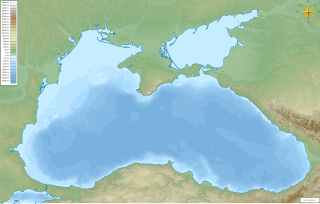
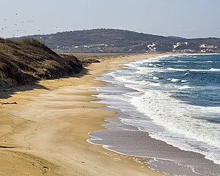
The Bulgarian Black Sea Coast, also known as the Bulgarian Riviera, covers the entire eastern bound of Bulgaria stretching from the Romanian Black Sea resorts in the north to European Turkey in the south, along 378 km of coastline. White and golden sandy beaches occupy approximately 130 km of the 378 km long coast. The region is an important center of tourism during the summer season (May–October), drawing millions of foreign and local tourists alike and constituting one of the country's most popular tourist destinations. Prior to 1989 the Bulgarian Black Sea coast was internationally known as the Red Riviera. Since the fall of the Iron Curtain, however, its nickname has been changed to the Bulgarian Riviera.

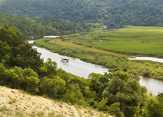
The Iskar is a right tributary of the Danube. With a length of 368 km it is the longest river that runs entirely within Bulgaria. Originating as three forks in Balkan's highest mountain range Rila, it flows in northern direction until its confluence with the Danube River. As it flows northwards it fuels the largest artificial lake in the country, the Iskar Reservoir, forms the divide between the Vitosha and Plana Mountains in the west and the Sredna Gora mountain range in the east before entering the Sofia Valley, which contains the nation's capital Sofia. From there the Iskar runs through the Balkan Mountains forming the spectacular 84 km long Iskar Gorge and as it crosses the mountains its water course turns in north-eastern direction at Lakatnik. North of the Balkan Mountains the river crosses the Danubian Plain and finally flows into the Danube between the villages of Baykal and Gigen. Geologically, Iskar is the oldest river in the Balkan Peninsula.

Tsarevo is a town and seaside resort in southeastern Bulgaria, an administrative centre of the homonymous Municipality of Tsarevo in Burgas Province. In the past, it was known as Vasiliko and Michurin. It lies on a cove 70 km southeast of Burgas, on the southern Bulgarian Black Sea Coast at the eastern foot of Strandzha mountain, at a few kilometers from Strandzha Nature Park. As of December 2009, the town has a population of 5,884 inhabitants.

St. Ivan Island is the largest Bulgarian island in the Black Sea, with an area of 0.66 square kilometres. It lies off the Bulgarian Black Sea Coast near Sozopol, a town with rich history and a popular tourist place, and is separated by a strait several hundred metres long from the small neighbouring St. Peter Island. Standing at 33 metres above sea level, it is also the highest of the Bulgarian sea islands. It lies 920 metres from the Stolets peninsula, the location of Sozopol's Old Town.
The Ropotamo is a river in south-eastern Bulgaria. It takes its source from the Bosna Ridge in the Strandzha Mountains, running for 48.5 km to empty into the Black Sea near Cape Saint Demetrius between Dyuni and Primorsko.
Dyuni is a holiday town and seaside resort on the Bulgarian Black Sea Coast, 40 km south of the Bulgarian city of Burgas and 7 km from Sozopol. The construction of the resort began in 1987 by an Austrian company and after a Bulgarian project.
Greeks in Bulgaria constitute the eighth-largest ethnic minority in Bulgaria. They number 1,356 according to the 2011 census. They are estimated at around 25,000 by Greek organizations and around 28,500 by the Greek government. The last numbers include the Sarakatsani community, the descendants of the post-WWII Greek emigrants, and other Greek citizens living in Bulgaria as students, businessmen, consorts etc. Today, Greeks mostly live in the large urban centres like Sofia and Plovdiv, but also in the coastal zone.
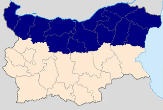
Northern Bulgaria, also called Moesia is the northern half of the territory of Bulgaria, located to the north of the main ridge of the Balkan Mountains which conventionally separates the country into a northern and a southern part. Besides the Balkan Mountains, Northern Bulgaria borders the Timok River and Serbia to the west, the Danube River and Romania to the north and the Bulgarian Black Sea Coast to the east.

Chernomorets is a town on the Black Sea coast of southeastern Bulgaria. Administratively part of Sozopol Municipality, Burgas Province, Chernomorets is a popular seaside resort.

Veselie is a village in Primorsko Municipality, Burgas Province, in southeastern Bulgaria. As of 2013 it has 539 inhabitants.

Atia or Atiya is a village in Sozopol Municipality, Burgas Province, south-eastern Bulgaria. As of 2013 it has 825 inhabitants. It hosts Bulgaria's largest naval base.

Rosen is a village in Sozopol Municipality, in Burgas Province, in south-eastern Bulgaria. As of 2013 it has 1470 inhabitants.

Antheia was a town on the western coast of the Pontus Euxinus in ancient Thrace, a colony of the Milesians and Phocaeans. It later bore the Latin name Anthium, and was the precursor settlement to Apollonia Pontica. It was located on the Gulf of Burgas between the modern cities of Burgas and Sozopol in Bulgaria.