
Antipatris was a city built during the first century BC by Herod the Great, who named it in honour of his father, Antipater. The site, now a national park in central Israel, was inhabited from the Chalcolithic Period to the late Roman Period. The remains of Antipatris are known today as Tel Afek, although formerly as Kŭlat Râs el 'Ain. It has been identified as either the tower of Aphek mentioned by Josephus, or the biblical Aphek, best known from the story of the Battle of Aphek. During the Crusader Period the site was known as Surdi fontes, "Silent springs". The Ottoman fortress known as Binar Bashi or Ras al-Ayn was built there in the 16th century.

Rosh HaAyin is a city in the Central District of Israel. In 2022, it had a population of 73,678.

The Tel Aviv Light Rail, also known as Dankal is a mass transit system for Gush Dan, the Tel Aviv metropolitan area in central Israel. The system will include different modes of mass transit, including rapid transit (metro), light rail transit (LRT), and bus rapid transit (BRT). Overseen by NTA Metropolitan Mass Transit System Ltd., a government agency, the project will complement the intercity and suburban rail network operated by Israel Railways.
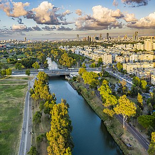
The Yarkon River, also Yarqon River or Jarkon River, is a river in central Israel. The source of the Yarkon is at Tel Afek (Antipatris), north of Petah Tikva. It flows west through Gush Dan and Tel Aviv's Yarkon Park into the Mediterranean Sea. Its Arabic name, al-Auja, means "the meandering". The Yarkon is the largest coastal river in Israel, at 27.5 km in length.
Petah Tikva is a city in the Central District of Israel.

Hadera Ma'arav (West) railway station is an Israel Railways passenger station and freight terminal located in the city of Hadera. It serves the city, including its large industrial zones, as well as other small communities in the area.
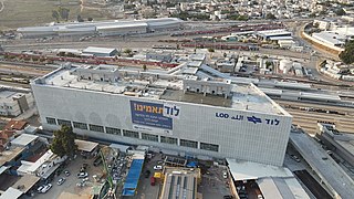
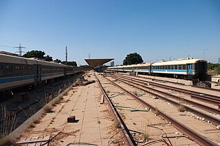
Lod railway station is an Israel Railways station in Lod, Israel, served by most railway lines of Israel Railways. The station is located in the HaRakevet district of south Lod. In December 2006, Lod Station served a daily average of 7,786 passengers.

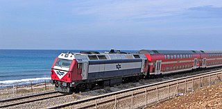
Rail transport in Israel includes heavy rail as well as light rail. Excluding light rail, the network consists of 1,511 kilometers (939 mi) of track, and is undergoing constant expansion. All of the lines are standard gauge and as of 2023 approximately one-fifth of the heavy rail network is electrified, with additional electrification work underway. A government owned rail company, Israel Railways, manages the entire heavy rail network. Most of the network is located on the densely populated coastal plain.
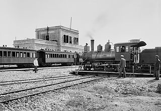
The Jaffa–Jerusalem railway is a railway that connected Jaffa and Jerusalem. The line was built in the Mutasarrifate of Jerusalem by the French company Société du Chemin de Fer Ottoman de Jaffa à Jérusalem et Prolongements and inaugurated in 1892. The project was headed by Joseph Navon, an Ottoman Jewish entrepreneur from Jerusalem, after previous attempts by the British-Jewish philanthropist Sir Moses Montefiore failed. While the first rail track in the Middle East was laid elsewhere, the line is considered to be the first Middle Eastern railway.
The Railway to Beersheba is a railroad line that runs from central Israel to the Zin Factories in southern Israel, with a spur to the Be'er Sheva Center Railway Station and branch lines to Ramat Hovav, the Arad phosphate mines and factories in Tzefa, and a connection to the Ashkelon–Beersheba railway. It is part of the main line of Israel Railways, of which the northern starting point of the line designated as the "line to Beersheba" is usually indicated as beginning at Na'an junction, where the railway splits to Beersheba and Jerusalem. Because the line is not limited to Beersheba, it is known in Israel as Mesilat HaDarom.

Bnei Brak–Ramat HaHayal railway station is a suburban passenger railway station in Israel, operated by Israel Railways. It is located on the Yarkon Railway near the Bnei Brak–Ramat Gan and Bnei Brak–Tel Aviv borders next to the Ayalon Mall and Ramat Gan Stadium. In spite of its proximity to important industrial and commercial areas of Gush Dan as well as to residential areas of Tel Aviv, Bnei Brak is one of the less-popular stations of Israel Railways, possibly because of its misleading name and lack of awareness. As a result, in an effort to increase the public's awareness of the station, the name of the Ramat HaHayal neighborhood located to the north of the station was added to the station's name in 2016.

Herzliya railway station is an Israel Railways passenger station located in the city of Herzliya. The station currently has three island platforms serving two tracks each. In the 2010s, the Ayalon Highway was extended past the station northwards so that the platforms lie contained in the median of the highway, like the train stations in Tel Aviv.

The Jaffa railway station was the first railway station in the Middle East, serving as the terminus for the Jaffa–Jerusalem railway. The station, located in the neighbourhood of Manshiya in Jaffa, was inaugurated in 1891 and closed in 1948. Between 2005 and 2009 the station was restored and converted to an entertainment and leisure venue, branded as The Station (HaTachanah). The Elifelet light rail station in the Red Line is located within the grounds of the historical station, which until 2019 were home to the Israel Defense Forces History Museum.
Tel Aviv South railway station was the name of two former railway stations in Tel Aviv, Israel, which were situated in two different locations. The original station opened in 1920, then in 1970 it was relocated 2.5 km south-east, and it finally closed to passengers in 1993.
The Coastal railway line is a mainline railway in Israel, which begins just south of the Lebanon-Israel border on the Mediterranean coast, near the town of Nahariya in Northern Israel and stretches almost the entire Mediterranean coast of the country, to just north of the border with the Gaza Strip in the south.
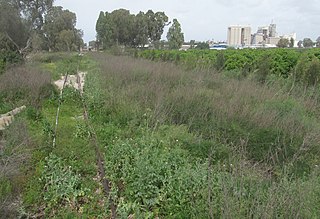
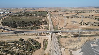
The Eastern Railway refers to a railroad in central Israel stretching from Lod to Hadera. The section between Kfar Saba and Lod, as well as a short section just north of Hadera are currently in use but the rest of the railway has not been operative since 1969. However, in 2019 a large-scale project began to rebuild and upgrade the railway along the entire route.
The 1968–69 Israel State Cup was the 30th season of Israel's nationwide football cup competition and the 15th after the Israeli Declaration of Independence.

Hadera East railway station is a former railway station in Hadera, Israel. It originally served as the northern terminus of the Eastern Railway. In 1968, the line was closed to passengers and the railway south of the station to Kfar Saba was abandoned. A short section of the Eastern Railway connecting the station north to the Coastal railway line was left in operation—being used by freight trains serving the Granot "Ambar North" large feed mill complex near Gan Shmuel that is located adjacent to Hadera East station.
The Yarkon Railway is a double-track railroad following the course of the Yarkon River in the central area of Israel. It is about 15 km long, stretching from the Coastal Railway to the Eastern Railway.
The Lod–Ashkelon railway is a railway line linking Lod and Ashkelon. It is operated by Israel Railways, and spans approximately 50 km of mostly double track in central and southern Israel.


