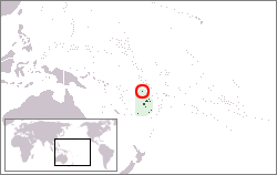
The Rotuma Group is a group of volcanic islands, with Rotuma Island being the main island, located at 12°35′S177°10′E / 12.583°S 177.167°E , approximately 465 km north of Fiji.
There are some islands located at a distance between 50 m and 2 km from the main island, but still within the fringing reef: Solnohu (south), Solkope (southeast), ʻAfgaha (far southeast), Husia (close southeast), as well as Hạua and Hạuameaʻmeʻa (close together northeast). Additionally, there is a separate chain of islands between three and six km northwest and west of the westernmost point of Rotuma Island. From northeast to southwest, those are Uea, Hạfhai with nearby Hạfhahoi, Hạfhaveiaglolo, Hatana and Hạfliua. [1]
The islands have an aggregate area of 44 km2, of which the main island Rotuma occupies 43 km2. Only the main island is permanently inhabited.
The Rotuma Group comprises a Dependency of Fiji. The population of the dependency at the 1996 census was 2810.

Fiji is a group of volcanic islands in the South Pacific, lying about 4,450 kilometres (2,765 mi) southwest of Honolulu and 1,770 km (1,100 mi) north of New Zealand. Of the 332 islands and 522 smaller islets making up the archipelago, about 106 are permanently inhabited. The total land size is 18,272 km2 (7,055 sq mi). It has the 26th largest Exclusive Economic Zone of 1,282,978 km2 (495,361 sq mi).
Rotuma is a Fijian dependency, consisting of Rotuma Island and nearby islets. The island group is home to a large and unique Polynesian indigenous ethnic group which constitutes a recognisable minority within the population of Fiji, known as "Rotumans". Its population at the 2017 census was 1,594, although many more Rotumans live on mainland Fijian islands, totaling 10,000.
Solkope is a small and densely wooded island off the southern coast of Rotuma in the Fiji Islands, at the edge of the fringing coral reef. It is separated from the main island of Rotuma by a channel that is between 50 and 200 m wide, and lies immediately southeast of the village of Kalvaka in the district of Noaʻtau. It 765 m long east–west, and up to 515 m wide, and rises to a height of 128 m. Its area is 0.3 km2. From the sea, it cannot be recognised as a separate island.
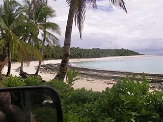
Motusa is a group of close villages in the district of Itu'tiu, on the island of Rotuma, one of the islands of Fiji. Rotuma is made up of two volcanic landmasses connected by a sandy isthmus, on which Motusa is located. For this reason it has one of the islands longest white sandy beach. Motusa also sits between the Islands two largest bay; Maka Bay to the North and Hapmafau Bay to the South.
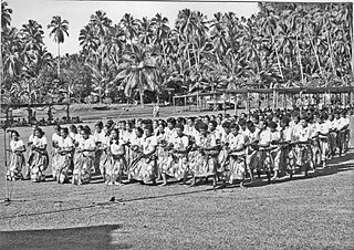
Dance in Rotuma refers to the traditional and modern dance styles performed by the people of the island of Rotuma, which became a dependency of Fiji in 1881. Despite Rotuma's political and historical links with Fiji, the island's culture shows strong Polynesian influences, particularly from Samoa and Tonga, which, along with Fiji, feature strongly in the history and traditions of the Rotuman people.

Ituʻtiʻu is one of the seven districts on the island of Rotuma, a dependency of Fiji. Rotuma's capital, the village of Ahau, is located in this district. It also includes the villages of Savlei, Lau, Feavai, Tuakoi, Motusa, Ropure, Melsaʻa, and Losa.
Hạfliua or Hofliua, also known as Split Island, is an islet which falls under the governing jurisdiction of the Fijian dependency of Rotuma.

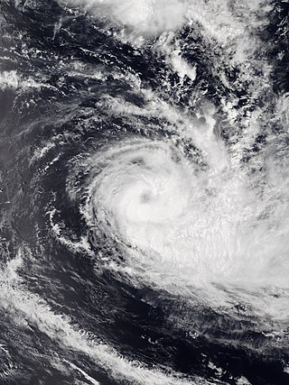
Severe Tropical Cyclone Daman was the strongest cyclone of the 2007–08 South Pacific cyclone season. Cyclone Daman was the fourth tropical depression and the first severe tropical cyclone to form east of longitude 180° during the 2007–08 South Pacific cyclone season. Due to the severity of the storm, the name Daman was retired and replaced with Denia.
Hatana Island is considered the most sacred or "haʻa" islet of the Rotuma Group, Fiji, commonly featuring in various Rotuman Creation myths.
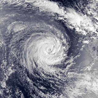
Severe Tropical Cyclone Gene was the deadliest storm as well as the most damaging tropical cyclone of the 2007–08 South Pacific cyclone season east of 160ºE. RSMC Nadi monitored Gene as the 12th tropical disturbance, as well as the fourth tropical cyclone and the third severe tropical cyclone to form west of 160ºE during the 2007–08 South Pacific cyclone season. Gene was also recognised by RSMC Nadi as the fifth tropical cyclone and fourth severe tropical cyclone to form within the South Pacific Ocean during the 2007-08 season.

The 1992–93 South Pacific cyclone season was an above-average tropical cyclone season with ten tropical cyclones occurring within the South Pacific to the east of 160°E. The season officially ran from November 1, 1992, to April 30, 1993, with the first disturbance of the season forming on December 3 and the last disturbance dissipating on April 6.

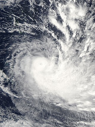
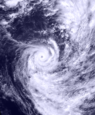
Severe Tropical Cyclone Susan was one of the most intense tropical cyclones on record within the South Pacific basin. It was first noted on December 20, 1997, as a weak tropical disturbance located to the north of American Samoa. Over the next 12 days, the disturbance remained weak while it gradually moved towards the southwest before it started to rapidly develop on January 2, 1998 while it was located near the Fijian dependency of Rotuma. The disturbance was declared a tropical cyclone later that day, but was not named Susan until the next day, after it had intensified into a category 2 tropical cyclone on the Australian Scale. Over the next few days, Susan moved towards the southwest and continued to intensify before it reached its peak intensity as a category five tropical cyclone during January 5 while it was located about 400 km (250 mi) to the northwest of Vanuatu's capital city Port Vila.

Severe Tropical Cyclone Joni was a damaging tropical cyclone that impacted the island nations of Tuvalu and Fiji. It was first noted within the South Pacific Convergence Zone at the start of December 1992, as a shallow tropical depression in the vicinity of the island nation Tuvalu. Over the next few days the system gradually developed further as it affected Tuvalu, before it was declared to be a tropical cyclone and named Joni by the Fiji Meteorological Service (FMS) during December 7. Over the next couple of days the system intensified further as it was steered south-westwards and posed a threat towards the Fijian dependency of Rotuma and the French territory of Wallis and Futuna. The system subsequently peaked as a Category 4 severe tropical cyclone on the Australian tropical cyclone intensity scale as it approached the Fijian Islands during December 10. Over the next couple of days the system moved through the Fijian Islands, before it became an extratropical cyclone during December 13. The system was last noted during the next day as it was absorbed by a mid-latitude trough of low pressure to the east of New Zealand.
Severe Tropical Cyclone Gavin was the most intense tropical cyclone to affect Fiji, since Cyclone Oscar of the 1982–83 cyclone season and was the first of three tropical cyclones to affect the island nations of Tuvalu and Wallis and Futuna during the 1996–97 season. The system that was to become Gavin was first identified during March 2, as a weak tropical depression that had developed within the monsoon trough of low pressure. Over the next two days the depression gradually developed further, before it was named Gavin by RSMC Nadi early on March 4 as it had developed into a tropical cyclone.

Severe Tropical Cyclone Bebe, also known as Hurricane Bebe, was a pre-season storm during October 1972 in the South Pacific Ocean that severely affected Fiji, the Ellice Islands, and the Gilbert Islands.
Severe Tropical Cyclone Raja was a tropical cyclone that holds the 24-hour rainfall record of 674.9 mm (26.57 in) for the French Overseas Territory of Wallis and Futuna. The system was first noted by the Fiji Meteorological Service (FMS) as a weak tropical disturbance northeast of Tokelau in mid-December 1986. The system developed further as it moved southwest over the next few days, and it was classified as Tropical Cyclone Raja on 23 December. The newly named system slowed and unexpectedly recurved southeast towards the French territory of Wallis and Futuna on 24 December. Over the next two days, Raja interacted with what would become Severe Cyclone Sally and executed a tight loop, passing within 55 km (35 mi) of Futuna. The system peaked as a Category 3 severe tropical cyclone on 28 December, with estimated 10-minute sustained winds of 90 mph (150 km/h). The storm turned southwest the next day and threatened Fiji, where it passed within 20 km (10 mi) of Vanua Levu and near several smaller islands in the Lau group during the following day. Raja gradually weakened over the next few days as it moved south of Fiji; it was last noted on 5 January 1987 after it filled up over the north Tasman Sea.

Severe Tropical Cyclone Tino was a tropical cyclone which itself and an associated convergence zone caused significant damage across ten island nations in the South Pacific Ocean during January 2020. First noted as a tropical disturbance during January 11, to the southwest of Honiara in the Solomon Islands, the system gradually developed over the next few days as it moved eastwards in between the Solomon Islands and Vanuatu prior to being named Tino as it approached Fiji during January 16. Continuing to track south-eastward, Tino continued strengthening as it passed near Fiji, bringing copious amounts of rainfall to the area. Whilst losing latitude, the system continued to strengthen and peaked as a category 3 tropical cyclone on January 17, with signs of an eye forming. Shortly after peak intensity, Tino was impacted by high wind shear and decreasing sea surface temperatures, triggering a weakening trend. Tino moved out of the tropics shortly thereafter and became an extratropical cyclone during January 19.
The following is a list of all reported tropical cyclones within the South Pacific Ocean to the east of 160°E during the 1960s.

The Fiji tropical moist forests is a tropical moist forest ecoregion in Fiji and Wallis and Futuna. It covers the windward sides of Viti Levu and Vanua Levu, Fiji's largest islands, as well as the smaller Fijian islands and the three islands that make up Wallis and Futuna, an overseas territory of France.
Tropical Cyclone Sarai was a moderately strong tropical cyclone that impacted several island nations and countries in late-December 2019. The third tropical cyclone and the second named storm of the 2019-20 South Pacific cyclone season, Sarai formed from an area of low pressure to the south of Tuvalu. Over the next days, the low pressure became organized and was designated by the Fiji Meteorological Service as Tropical Disturbance 03F on December 23. Under favorable conditions, the disturbance gradually organized, becoming a depression two days later, before strengthening to a tropical cyclone, earning the name Sarai. It moved to the south, before a high-pressure steered the system to the east, passing to the south of Fiji, near Suva before weakening. Sarai passed near the Tongan islands of Haʻapai and Tongatapu as a Category 1 cyclone, before rapidly degrading to a tropical depression due to the system entering unfavorable conditions. It was last noted on January 2 to the southeast of Cook Islands.
| General | |
|---|---|
| National libraries | |
| | This article about a geographical location in Fiji is a stub. You can help Wikipedia by expanding it. |