
Akutan (ACK-oo-tan) is a city on Akutan Island in the Aleutians East Borough of the Aleutian Islands in Alaska, United States. The population was 1,027 at the 2010 census, up from 713 in 2000. Akutan Harbor is adjacent.

St. George is a city in Aleutians West Census Area, Alaska, United States. At the 2010 census the population was 102, down from 152 in 2000. It is the main settlement of St. George Island in the Pribilofs, a small island group in the Bering Sea.

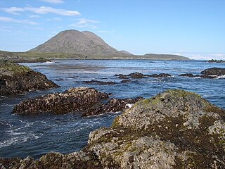
Unimak Island is the largest island in the Aleutian Islands chain of the U.S. state of Alaska.
Sanak Island is an island in the Fox Islands group of the Aleutian Islands in the U.S. state of Alaska. It is located at 54°25′47″N162°42′32″W.

Funter Bay is a two-mile-long (3 km) bay on the western side of Admiralty Island near its northern tip, in the Alexander Archipelago of the U.S. state of Alaska. It lies within the Hoonah-Angoon Census Area, in the Unorganized Borough of Alaska.

Aiktak Island is one of the Krenitzin Islands, a subgroup of the Fox Islands in the eastern Aleutian Islands in the U.S. state of Alaska. It is 1.3 miles (2.1 km) long and is located 38 miles (61 km) east of Akutan Island. Aiktak is an Aleut name transcribed by Captain Tebenkov in 1852 as "Ostrov Aikhtak." R. H. Geoghegan suggested that the name is derived from the Aleut "aikhag", meaning "travel or going on a voyage." It is also known as Ashmiak.
Tigalda Island is one of the Krenitzin Islands, a subgroup of the Fox Islands in the eastern Aleutian Islands, Alaska. Tigalda is located about 19 miles (31 km) east of Akutan Island, is 12 miles (19 km) long and has an area of about 35 square miles (91 km2). Tigalda is an Aleut name published by Captain Lutke (1836). It was called "Kagalga" by Captain Lt. Krenitzin and Lt. Levashev (1768). Tigalda Bay is situated on the north side of Tigalda. Father Veniaminov (1840) reported the existence of an Aleut village, which he called "Tigaldinskoe", of 91 people in 1833. Tigalda is uninhabited.
Ugamak Island is one of the Krenitzin Islands, a subgroup of the Fox Islands group of the eastern Aleutian Islands, Alaska. Ugamak is an Aleut word transcribed by Father Veniaminov (1840) which, according to R. H. Geoghegan, may mean "ceremony island". It is 5.9 miles (9.5 km) long and is located 32 miles (51 km) east of Akutan Island. Ugamak Bay is situated on the southeast coast of Ugamak, and Ugamak Strait is a three-mile-wide channel that separates Ugamak from Kaligagan Island to the west.
Poa Island is an islet located about 0.99 miles (1.59 km) off the south coast of Akun Island in the Fox Islands group of the eastern Aleutian Islands, Alaska. The island is 0.62 miles (1.00 km) long and reaches a maximum elevation of about 200 feet (61 m) above sea level. It was named for a genus of grasses in 1888 by the U.S. Bureau of Fisheries. Captain Tebenkov (1852) called it "Ostrov Tumannyi," meaning "foggy island."
Amlia is an island in the Aleutian Islands. It is located near the eastern end of the Andreanof Islands and is situated between Atka Island and Seguam Island.
Great Sitkin Island is a volcanic island in the Andreanof Islands of the Aleutian Islands of Alaska. The island covers a total area of 60 square miles (160 km2) and lies slightly north of a group of islands which are located between Adak Island and Atka Island.
Kagalaska Island is an island in the Andreanof Islands of the Aleutian Islands of Alaska.
Ulak Island is an island in the Delarof Islands subgroup of the Andreanof Islands in the Aleutian Islands chain of Alaska.
Unalga Island is one of the Fox Islands subgroup of the Aleutian Islands of southwestern Alaska, United States. It lies just northeast of Unalaska Island and across Akutan Pass from Akutan Island to its northeast. It is the westernmost island in the Aleutians East Borough. Unalga Island has a land area of 11.004 square miles and is unpopulated. The island is 6.7 kilometres (4.2 mi) long and 8.2 kilometres (5.1 mi) wide.
Akun Island is one of the Fox Islands subgroup of the Aleutian Islands in the Aleutians East Borough of southwestern Alaska.
Herbert Island is an island in the Islands of Four Mountains subgroup of the Aleutian archipelago. It is 3.1 miles (5.0 km) from Chuginadak Island, separated by the Chuginadak Pass. Yunaska Island is 16 miles (26 km) northwest of Herbert Island. Measuring 6.2 miles (10.0 km) across, Herbert Island is somewhat circular in shape and is covered by the 4,200-foot (1,300 m) Herbert Volcano, whose 2-kilometre (1.2 mi) wide caldera is one of the largest in the Aleutian Islands. There have been no recorded eruptions here.
Kagamil Island, in the Islands of Four Mountains subgroup of the Aleutian archipelago, is 3.7 miles (6.0 km) north of Chuginadak Island and 1.2 miles (1.9 km) south of Uliaga Island. It is 6.2 miles (10.0 km) in length and up to 3.1 miles (5.0 km) in width. The southern half of the island is dominated by the Kagamil Volcano, which has two summits: one is 2,930 feet (890 m) above sea level, while the other is lower at 2,260 feet (690 m).
Anangula Island is a small island in the Fox Islands group of the Aleutian Islands of southwestern Alaska. The 1.4-mile (2.3 km)-long island is separated from Umnak Island by a channel about 0.93 miles (1.50 km) wide and consists of a mostly barren tundra landscape of volcanic ash.
The Aleutian Islands are a chain of 14 large volcanic islands and 55 smaller ones belonging to both the U.S. state of Alaska and the Russian federal subject of Kamchatka Krai. They form part of the Aleutian Arc in the Northern Pacific Ocean, occupying an area of 6,821 sq mi (17,666 km2) and extending about 1,200 mi (1,900 km) westward from the Alaska Peninsula toward the Kamchatka Peninsula in Russia, and mark a dividing line between the Bering Sea to the north and the Pacific Ocean to the south. Crossing longitude 180°, at which point east and west longitude end, the archipelago contains both the westernmost part of the United States by longitude and the easternmost by longitude. The westernmost U.S. island in real terms, however, is Attu Island, west of which runs the International Date Line. While nearly all the archipelago is part of Alaska and is usually considered as being in the "Alaskan Bush", at the extreme western end, the small, geologically related Commander Islands belong to Russia.
