
The history of Antarctica emerges from early Western theories of a vast continent, known as Terra Australis, believed to exist in the far south of the globe. The term Antarctic, referring to the opposite of the Arctic Circle, was coined by Marinus of Tyre in the 2nd century AD.

Peter I Island is an uninhabited volcanic island in the Bellingshausen Sea, 450 kilometres (280 mi) from continental Antarctica. It is claimed as a dependency of Norway, and along with Bouvet Island and Queen Maud Land comprises one of the three Norwegian dependent territories in the Antarctic and Subantarctic. Peter I Island is 11 by 19 kilometres long and 156 square kilometres (60 sq mi), slightly larger than Staten Island as an example. The tallest peak is the ultra and 1,640-meter (5,380 ft) tall Lars Christensen Peak. Nearly all of the island is covered by a glacier and it is surrounded most of the year by pack ice, making it inaccessible during these times. There is little vertebrate animal life on the island apart from some seabirds and seals.

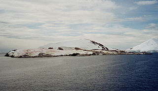
Elephant Island is an ice-covered mountainous island off the coast of Antarctica in the outer reaches of the South Shetland Islands, in the Southern Ocean. Its name was given by early explorers sighting elephant seals on its shores. The island is situated 245 kilometres north-northeast of the tip of the Antarctic Peninsula, 1,253 kilometres west-southwest of South Georgia, 935 kilometres south of the Falkland Islands, and 885 kilometres southeast of Cape Horn. It is within the Antarctic claims of Argentina, Chile and the UK. Brazil has a shelter on the island, Goeldi, supporting the work of up to six researchers each during the summer and had another (Wiltgen), which was dismantled in the summer of 1997/98.

New Swabia is a cartographic name sometimes given to an area of Antarctica between 20°E and 10°W in Queen Maud Land, which is claimed as a Norwegian dependent territory under the Antarctic Treaty System. New Swabia was explored by Germany in early 1939 and named after that expedition's ship, Schwabenland, itself named after the German region of Swabia.
Petermann Island is a small, low and rounded island, lying off the northwest coast of Kiev Peninsula in Graham Land, Antarctica, a short distance south of Booth Island and the Lemaire Channel. It is a popular tourist destination.
The Australian National Antarctic Research Expeditions is the historical name for the Australian Antarctic Program (AAp) administered for Australia by the Australian Antarctic Division (AAD).
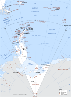
Argentine Antarctica is a sector of Antarctica claimed by Argentina as part of its national territory consisting of the Antarctic Peninsula and a triangular section extending to the South Pole, delimited by the 25° West and 74° West meridians and the 60° South parallel. This region overlaps with British and Chilean claims in Antarctica; however, all claims are suspended by the Antarctic Treaty System, of which Argentina is a founding signatory and permanent consulting member, with the Antarctic Treaty Secretariat being based in Buenos Aires.

Anvers Island or Antwerp Island or Antwerpen Island or Isla Amberes is a high, mountainous island 61 km long, the largest in the Palmer Archipelago of Antarctica. It was discovered by John Biscoe in 1832 and named in 1898 by the Belgian Antarctic Expedition under Adrien de Gerlache after the province of Antwerp in Belgium. It lies south-west of Brabant Island at the south-western end of the group. The south-western coastline of the island forms part of the Southwest Anvers Island and Palmer Basin Antarctic Specially Managed Area. Cormorant Island, an Important Bird Area, lies 1 km off the south coast.

Brabant Island is the second largest island of the Palmer Archipelago within the British Antarctic Territory, lying between Anvers Island and Liège Island. Brabant Island is 59 km (37 mi) long north-south, 30 km (19 mi) wide, and rises to 2,520 m (8,268 ft) in Mount Parry. The interior of the island is occupied by two mountain ranges, Solvay Mountains in its southern part and Stribog Mountains in its central and northern parts.

Palmer Archipelago, also known as Antarctic Archipelago, Archipiélago Palmer, Antarktiske Arkipel or Palmer Inseln, is a group of islands off the northwestern coast of the Antarctic Peninsula. It extends from Tower Island in the north to Anvers Island in the south. It is separated by the Gerlache and Bismarck straits from the Antarctic Peninsula and Wilhelm Archipelago, respectively.
The Ronne Antarctic Research Expedition (RARE) was an expedition from 1947–1948 which researched the area surrounding the head of the Weddell Sea in Antarctica.

Henryk Arctowski Polish Antarctic Station is a research station on King George Island, off the coast of Antarctica.

A number of governments have set up permanent research stations in Antarctica and these bases are widely distributed. Unlike the drifting ice stations set up in the Arctic, the research stations of the Antarctic are constructed either on rock or on ice that is fixed in place.

The Swedish Antarctic Expedition (1901–1904) was led by Otto Nordenskjöld and Carl Anton Larsen.
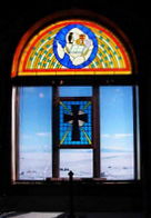
Antarctica has various places of worship and an increasing demand for religious services and construction of sacred architecture on the continent. In spite of the famous saying "below 40 degrees south there is no law; below 50 degrees south there is no God" the exploration of the continent was in fact closely connected to religious activities with contributions from many adherents. Some of the early religious buildings are now protected as important historical monuments. Christian buildings are the only religious buildings on the continent.

The Jocelyn Islands are a group of islands lying between the Flat Islands and the Rouse Islands in the eastern part of Holme Bay, Mac. Robertson Land, Antarctica. The group, which is made up the Lee Island, Verner Island, and Petersen Island, were mapped by Norwegian cartographers from air photos taken by the Lars Christensen Expedition, 1936–37, and named Meholmane. They were renamed in 1960 by Australian National Antarctic Research Expeditions (ANARE) for Jocelyn Terry, who for a number of years broadcast news and messages to Antarctica from Radio Australia.

East Base on Stonington Island is the oldest American research station in Antarctica, having been commissioned by Franklin D. Roosevelt in 1939. The station was built as part of two US wintering expeditions – United States Antarctic Service Expedition (1939–1941) and Ronne Antarctic Research Expedition (1947–1948). The base covers 1,000 metres (3,300 ft) from north to south and 500 metres (1,600 ft) from east to west. The base was accorded the status of one of the Historic Sites and Monuments in Antarctica on 7 May 2004.


