
The Maryland Transit Administration (MTA) is a state-operated mass transit administration in Maryland, and is part of the Maryland Department of Transportation. It is better known as MTA Maryland to avoid confusion with other cities' transit agencies who share the initials MTA. The MTA operates a comprehensive transit system throughout the Baltimore-Washington Metropolitan Area. There are 80 bus lines serving Baltimore's public transportation needs, along with other services that include the Light Rail, Metro Subway, and MARC Train. With nearly half the population of Baltimore residents lacking access to a car, the MTA is an important part of the regional transit picture. The system has many connections to other transit agencies of Central Maryland, Washington, D.C., Northern Virginia, and south-central Pennsylvania : WMATA, Charm City Circulator, Regional Transportation Agency of Central Maryland, Annapolis Transit, Rabbit Transit, Ride-On, and TransIT.

Metrobus is a bus service operated by the Washington Metropolitan Area Transit Authority (WMATA). Its fleet consists of 1,595 buses covering an area of 1,500 square miles (3,900 km2) in Washington, D.C., Maryland and Virginia. There are 269 bus routes serving 11,129 stops, including 2,554 bus shelters. In 2016, Metrobus provided approximately 123.6 million trips. On a typical weekday in June 2017, it provided more than 390,000 trips.
Route 40 is a limited stop bus route, identified as a "QuickBus", operated by the Maryland Transit Administration in Baltimore and its suburbs. The line currently runs from the Centers for Medicare and Medicaid Services in Woodlawn to Middle River, both in Baltimore County, Maryland with selected trips terminating at Downtown Baltimore City Hall, passing through the west and east sides and the downtown area of Baltimore City. Service operates every 12 minutes during rush hour, and every 15 minutes at most other times during its hours of operation. The line serves the corridors of Edmondson Avenue in West Baltimore, including the communities of Edmondson Village, Allendale, and Rosemont, and Fayette Street and Eastern Avenue in East Baltimore, serving Patterson Park, Johns Hopkins Bayview Medical Center and Essex.

Route 10 is a bus route operated by the Maryland Transit Administration in Baltimore and its suburbs. The line currently runs from the Wal-Mart parking lot in Catonsville to Bullneck Road/Turner's Station Dundalk mostly along the corridors of Frederick Road on the west side and Eastern Avenue on the east side, serving the communities of Yale Heights, Pigtown, downtown Baltimore, Fells Point, and Highlandtown.
Route 13 is a bus route operated by the Maryland Transit Administration in Baltimore. The line currently runs from Walbrook Junction in West Baltimore to Canton, mostly along North Avenue. The line has two main branches, both operating to Canton: one that operates via Fells Point and the other via Linwood and East Streets. Both these branches serve Johns Hopkins Hospital. Additionally, selected trips on weekdays and Saturdays operate to the block of Milton Avenue, Federal Street, and Patterson Park Avenue.
Route 20 is a bus route operated by the Maryland Transit Administration in Baltimore and its suburbs. The line currently runs from Security Square Mall east through downtown Baltimore to Baltimore City Hall. The main roads on which the line operates are Old Frederick Road, Baltimore Street, Fayette Street, and Boston Street. The line serves the communities of Westview, Edmondson Village.

The Maryland Transit Administration was originally known as the Baltimore Metropolitan Transit Authority, then the Maryland Mass Transit Administration before it changed to its current name in October 2001. The MTA took over the operations of the old Baltimore Transit Company on April 30, 1970.

The Maryland Transit Administration provides the primary public bus service for the Baltimore Metropolitan Area and commuter bus service in other parts of the state of Maryland. There are currently 76 bus routes, which include 43 LocalLink routes, 12 High Frequency CityLink Routes routes, 9 express bus routes, 19 commuter bus routes, and 5 Intercounty Connector or "ICC" routes. The local and commuter bus routes operate in conjunction with one subway line, three light rail lines, MARC train service, and various connections to other transit agencies.

Route 77 is a bus route operated by the Maryland Transit Administration in the suburbs of Baltimore. The line currently runs from the Old Court Metro Subway Station in Pikesville, Maryland to the Patapsco Light Rail Stop, and serves Randallstown, Windsor Mill, Woodlawn, Catonsville, Arbutus, Halethorpe, and Lansdowne, and the campuses of UMBC and CCBC Catonsville.
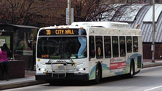
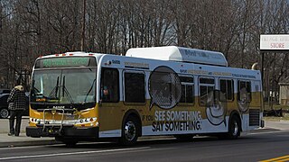
Route 30 was a bus route operated by the Maryland Transit Administration in Baltimore. The line ran from Edmondson Village in west Baltimore to Bayview Medical Center in southeast Baltimore during rush hour and City Hall during the midday until 20 February 2015.

Baltimore Highlands is a neighborhood in the Southeast District of Baltimore, located between the neighborhoods of Patterson Park and Kresson. Its boundaries are drawn by Pulaski Highway (north), East Baltimore Street (south), Haven Street (east) and North Clinton Street (west).

Beverly Hills is a neighborhood in the Northeast District of Baltimore, located between the neighborhoods of Moravia-Walther, Arcadia and Lauraville. Its boundaries are drawn by Harford Road (west), Weaver Avenue (south), Harcourt Road (east), Moravia Road (northeast) and Grindon Avenue (north).
Westgate is a neighborhood in the Southwest District of Baltimore, located between Baltimore County (west) and the city neighborhood of Ten Hills (east). Its boundaries are marked by Baltimore National Pike (north), Frederick Avenue (south), Rock Glen Avenue and Edmondson Avenue (east) and the city line (west).
Several special routes of U.S. Route 15 exist. In order from south to north they are as follows.
West Hills is a neighborhood in the Southwest District of Baltimore, located between the neighborhoods of Westgate (south), Franklintown (north) and Hunting Ridge (east). Its boundaries are drawn by the Baltimore County line (west), Baltimore National Pike (south) and North Franklintown Road (north). Its eastern boundary follows Cooks Lane from Baltimore National Pike, then Briarclift Road and finally Wynans Way to the intersection with N. Franklintown Road.

Regional Transportation Agency of Central Maryland, locally referred to as the RTA, is a transit organization developed to establish a more effective and efficient public transportation system across Central Maryland. The RTA is made up of multiple jurisdictions including Anne Arundel County, Howard County, City of Laurel and Northern Prince George's County. The RTA combined the management and administrative functions of multiple transit operations, reducing operating costs by over 10%, and provided a better customer service experience by improving connections across Central Maryland. The Commission allows all of the participating jurisdictions the ability to oversee transit management operations.
Better Waverly is a neighborhood in the North District of Baltimore, located between the neighborhoods of Charles Village (west) and Coldstream-Homestead-Montebello (east). Its boundaries are marked by East 33rd Street (north), Exeter Hall Avenue (south), Greenmount Avenue (west) and Loch Raven Road (east).
Martz Group is an apportioned bus company headquartered in Wilkes-Barre, Pennsylvania, operating intercity commuter buses, charter buses, and tours. The company operates Martz Trailways, which is a part of the Trailways Transportation System. Martz Trailways provides intercity commuter bus service from the Wyoming Valley cities of Wilkes-Barre and Scranton and the Pocono Mountains in Northeastern Pennsylvania to New York City and Philadelphia. The company also runs buses connecting Northeastern Pennsylvania to the casinos in Atlantic City, New Jersey and Wind Creek Bethlehem. Martz Group also operates the Gold Line commuter service and Gray Line sightseeing service in Washington, D.C., the National Coach Works in Fredericksburg, Virginia, and the First Class Coach Company Trailways serving Tampa and St. Petersburg in Florida.
Cecil Transit is a public transit agency providing bus service in Cecil County in the US state of Maryland. The agency, which is owned by Cecil County, operates fixed-route bus service along five routes serving the Cecil County towns of Elkton, North East, and Perryville along with service to Glasgow and Newark in Delaware. Cecil Transit offers connections to Harford Transit bus service and MARC's Penn Line service in Perryville, DART First State bus service in Glasgow and Newark, and SEPTA Regional Rail's Wilmington/Newark Line service in Newark. The fixed-route service allows for deviations of up to 3⁄4 mile (1.2 km) through advance reservations. The agency also operates a door-to-door demand responsive transport service called Demand Response for the general public, senior citizens, and disabled people.