
Hong Kong has a highly developed and sophisticated transport network, encompassing both public and private transport. Based on Hong Kong Government's Travel Characteristics Survey, over 90% of the daily journeys are on public transport, the highest rate in the world. However, in 2014 the Transport Advisory Committee, which advises the Government on transportation issues, issued a report on the much worsened congestion problem in Hong Kong and pointed at the excessive growth of private cars during the past 10–15 years.

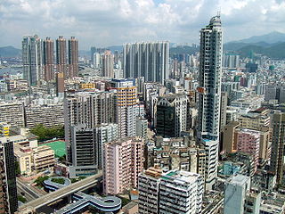
Kowloon is an urban area in Hong Kong comprising the Kowloon Peninsula and New Kowloon. With a population of 2,019,533 and a population density of 43,033/km2 in 2006, it is the most populous urban area in Hong Kong. The peninsula's area is about 47 km2 (18 sq mi).

Yau Tsim Mong District is one of 18 districts of Hong Kong, located on the western part of Kowloon Peninsula. It is the core urban area of Kowloon. The district has the second highest population density of all districts, at 49,115/km². The 2016 By-Census recorded the total population of Yau Tsim Mong District at 342,970.

Hung Hom is an area in the southeast of Kowloon Peninsula, Hong Kong. Including the area of Whampoa, Tai Wan, Hok Yuen, Lo Lung Hang and No. 12 Hill are administratively part of the Kowloon City District, with a portion west of Hung Hom Bay in the Yau Tsim Mong District. Hung Hom serves mainly residential purposes, but it is mixed with some industrial buildings in the north.
Sun Ferry Services Company Limited, formerly New World First Ferry Services, a ferry service company in Hong Kong. The company was established in November 1999, when it took over the eight licensed ferry routes transferred from Hongkong and Yaumati Ferry in January 2000.

Nathan Road is the main thoroughfare in Kowloon, Hong Kong, aligned south–north from Tsim Sha Tsui to Sham Shui Po. It is lined with shops and restaurants and throngs with visitors, and was known in the post–World War II years as the Golden Mile, a name that is now rarely used. It starts on the southern part of Kowloon at its junction with Salisbury Road, a few metres north of Victoria Harbour, and ends at its intersection with Boundary Street in the north. Portions of the Kwun Tong and Tsuen Wan lines run underneath Nathan Road. The total length of Nathan Road is about 3.6 kilometres (2.2 mi).
Tai Kok Tsui is an area west of Mong Kok in Kowloon, Hong Kong. The mixed land use of industrial and residential is present in the old area. The Cosmopolitan Dock and oil depots were previously located there. Blocks of high-rise residential buildings have been erected on the reclaimed area to the west, which marked the revitalization of the area with many restaurants and bars setting up shop. Many of the older residential buildings have been vacated and are set to be replaced by luxury high-rise buildings.
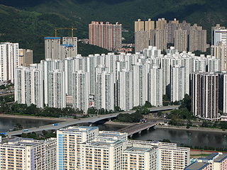
City One Shatin is a residential precinct in Sha Tin, New Territories, Hong Kong. The estate occupies approximately 1,800,000 square feet of land. The estate was named City One as it is on Lot 1, Shatin Town. It has a census area population of 24,758 people. City One is the largest private residential estate in Sha Tin District. There are a total of 52 blocks of residential buildings with 10,642 units. Each tower is about 30 storeys with units ranging from 389 square feet (36.1 m2) to an area of 1,018 square feet (94.6 m2), offering different floor plans.

Sham Shui Po District is one of 18 districts of Hong Kong. It is the poorest district in Hong Kong, with a predominantly working-class population of 405,869 in 2016 and the lowest median household income of all districts. Sham Shui Po has long been home to poorer new immigrants from mainland China. It also saw the birth of public housing in Hong Kong, as the government sought to resettle those displaced by a devastating fire in its slums. Sham Shui Po also hosted a Vietnamese refugee camp during the influx of migration in the aftermath of the Vietnam War.

West Kowloon Corridor is part of Route 5 in Hong Kong. Bypassing existing surface roads in West Kowloon, it connects Lai Chi Kok Road in Cheung Sha Wan with the Gascoigne Road Flyover near Yau Ma Tei.

Prince Edward Road East and Prince Edward Road West are roads in Kowloon, Hong Kong, going in an east-west direction and linking Tai Kok Tsui, Mong Kok, Kowloon Tong, Kowloon City and San Po Kong.
Route 5 is a route artery in Hong Kong from eastern to western Kowloon and New Kowloon, and ends in Tsuen Wan in the New Territories, linking Route 9. It is one of the most seriously congested routes in Kowloon, as it serves as an interchange to the Hung Hom Cross-Harbour Tunnel, especially during peak hours.

Jordan Road Ferry Pier or Ferry Point (1924–1998) is a demolished pier originally located at Jordan Road, Jordan, Hong Kong.

KMB Route 1 is a bus route operated in Kowloon, Hong Kong. It is run by Kowloon Motor Bus and connects Star Ferry and Chuk Yuen Estate in Wong Tai Sin. The bus runs via Tsim Sha Tsui, Yau Ma Tei, Mong Kok, Kowloon City and Lok Fu.
Mong Kok Ferry Pier (1924–1972) was a ferry pier to the west of Shantung Street, Mong Kok, Kowloon, Hong Kong, located inside the old Yau Ma Tei Typhoon Shelter. The site was covered over during land reclamation under the West Kowloon Reclamation Project.

KMB Route 1A is a bus route operated by Kowloon Motor Bus (KMB) in Hong Kong. It runs between Star Ferry and Sau Mau Ping (Central) and provides air-conditioned service. The route runs via Tsim Sha Tsui, Yau Ma Tei, Mong Kok, Kowloon City, San Po Kong, Ngau Tau Kok, Kwun Tong, and Sau Mau Ping.
Kowloon Central Cluster is one of the seven hospital clusters managed by Hospital Authority in Hong Kong. It consists of four public hospitals, two institutions and six general outpatient clinics to provide public healthcare services for the population of Yau Ma Tei, Mong Kok, Tsim Sha Tsui and Kowloon City and Wong Tai Sin. In mid-2012, the population was 1,103,200. The current Cluster Chief Executive is Albert Lo Chi-yuen.
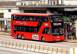
Air-Conditioned New Territories Route No. 290 and 290A are Hong Kong bus routes operated by Kowloon Motor Bus, plying between Choi Ming Court in Tseung Kwan O and Tsuen Wan West station.

