
Midlothian is a historic county, registration county, lieutenancy area and one of 32 council areas of Scotland used for local government. Midlothian lies in the east-central Lowlands, bordering the City of Edinburgh council area, East Lothian and the Scottish Borders.

The Scottish Borders is one of 32 council areas of Scotland. It is bordered by West Lothian, Edinburgh, Midlothian, and East Lothian to the north, the North Sea to the east, Dumfries and Galloway to the south-west, South Lanarkshire to the west, and the English ceremonial counties of Cumbria and Northumberland to the south. The largest settlement is Galashiels, and the administrative centre is Newtown St Boswells.

Falkirk is one of 32 unitary authority council areas of Scotland. It was formed on 1 April 1996 by way of the Local Government etc. (Scotland) Act 1994 from the exact boundaries of Falkirk District, one of three parts of the Central region created in 1975, which was abolished at that time. Prior to the 1975 reorganisation, the majority of the council area was part of the historic county of Stirlingshire, and a small part, namely Bo'ness and Blackness, was part of the former county of West Lothian.
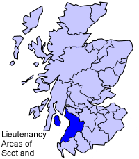
The lieutenancy areas of Scotland are the areas used for the ceremonial lord-lieutenants, the monarch's representatives, in Scotland. The lord-lieutenants' titles chosen by the monarch and his legal advisers are mainly based on placenames of the traditional counties of Scotland. In 1794 permanent lieutenancies were established by Royal Warrant. By the Militia Act 1797, the lieutenants appointed "for the Counties, Stewartries, Cities, and Places" were given powers to raise and command County Militia Units.

Berwickshire is a historic county, registration county and lieutenancy area in south-eastern Scotland, on the English border. The county takes its name from Berwick-upon-Tweed, its original county town, which was part of Scotland at the time of the county's formation in the twelfth century, but became part of England in 1482 after several centuries of swapping back and forth between the two kingdoms. After the loss of Berwick, Duns and Greenlaw both served as county town at different periods.

Lieutenancy areas, officially counties and areas for the purposes of the lieutenancies, are the separate areas of the United Kingdom appointed a lord-lieutenant – a representative of the British monarch. In many cases they have similar demarcation and naming to, but are not necessarily coterminate with, the counties of the United Kingdom.

Peeblesshire, the County of Peebles or Tweeddale is a historic county of Scotland. Its county town is Peebles, and it borders Midlothian to the north, Selkirkshire to the east, Dumfriesshire to the south, and Lanarkshire to the west.

Roxburghshire or the County of Roxburgh is a historic county and registration county in the Southern Uplands of Scotland. It borders Dumfriesshire to the west, Selkirkshire and Midlothian to the northwest, and Berwickshire to the north. To the southwest it borders Cumberland and to the southeast Northumberland, both in England.

Selkirkshire or the County of Selkirk is a historic county and registration county of Scotland. It borders Peeblesshire to the west, Midlothian to the north, Roxburghshire to the east, and Dumfriesshire to the south. It derives its name from its county town, the royal burgh of Selkirk. The county was historically also known as Ettrick Forest.

The Stirling council area is one of the 32 council areas of Scotland, and has a population of about 93,470. It was created in 1975 as a lower-tier district within the Central region. The district covered parts of the historic counties of Stirlingshire and Perthshire, which were abolished for local government purposes. In 1996 the Central region was abolished and Stirling Council took over all local government functions within the area.

Tweeddale is a committee area and lieutenancy area in the Scottish Borders council area in south-eastern Scotland. It had also been a province in the Middle Ages. From 1975 to 1996 it was a local government district. Its boundaries correspond to the historic county of Peeblesshire.
Ayrshire and Arran is a lieutenancy area of Scotland. It consists of the council areas of East Ayrshire, North Ayrshire and South Ayrshire. The area of Ayrshire and Arran is also a brand for tourist attractions.

Ettrick and Lauderdale was one of four local government districts in the Borders region of Scotland as well as a lieutenancy area from 1975 to 1996.

Annandale and Eskdale is a committee area in Dumfries and Galloway, Scotland. It covers the areas of Annandale and Eskdale, the straths of the River Annan and the River Esk respectively. From 1975 until 1996 it was a local government district.

Nithsdale, also known as Strathnith, Stranith or Stranit, is the strath or dale of the River Nith in southern Scotland. Nithsdale was one of the medieval provinces of Scotland. The provinces gradually lost their administrative importance to the shires created from the twelfth century, with Nithsdale forming part of Dumfriesshire. A Nithsdale district covering a similar area to the medieval province was created in 1975, based in the area's main town of Dumfries. The district was abolished in 1996, since when the area has been directly administered by Dumfries and Galloway Council.
The Stewartry was a local government district from 1975 until 1996 within the Dumfries and Galloway region in south-west Scotland. Under the name The Stewartry of Kirkcudbright the area of the former district is still used as a lieutenancy area. Dumfries and Galloway Council has a Stewartry area committee which approximately covers the same area, subject to some adjustments where ward boundaries no longer follow the pre-1996 district boundary. The Stewartry covers the majority of the historic county of Kirkcudbrightshire, and derives its name from the county's alternative name of the "The Stewartry of Kirkcudbright".
Midlothian in Scotland is a county constituency of the House of Commons of the Parliament of the United Kingdom. It elects one Member of Parliament (MP) by the first-past-the-post voting system.

Renfrew District was, between 1975 and 1996, one of nineteen local government districts in the Strathclyde region of Scotland.
This is a list of people who have served as Lord-Lieutenant of Kirkcudbright, part of the Dumfries and Galloway council area of south-west Scotland. Prior to 1975 the lieutenancy corresponded to the historic county of Kirkcudbrightshire. Since 1975 the lieutenancy area has been the slightly smaller Stewartry district, corresponding to the local government district of Stewartry established in 1975 and abolished in 1996. From 1975 until 1996 the title was the "Lord-Lieutenant for Dumfries and Galloway Region ". In 1996 the title was changed to "Lord-Lieutenant for the Stewartry of Kirkcudbright".

Wigtown is a lieutenancy area in south-west Scotland and a committee area of Dumfries and Galloway Council. From 1975 until 1996 it was also a local government district. It closely resembles the historic county of Wigtownshire, covering the whole area of that county but also including the two parishes of Kirkmabreck and Minnigaff from the historic county of Kirkcudbrightshire.
