
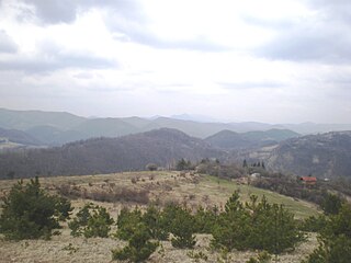
The Rhodopes are a mountain range in Southeastern Europe, and the largest by area in Bulgaria, with over 83% of its area in the southern part of the country and the remainder in Greece. Golyam Perelik is its highest peak at 2,191 meters (7,188 ft). The mountain range gives its name to the terrestrial ecoregion Rodope montane mixed forests that belongs in the temperate broadleaf and mixed forests biome and the Palearctic realm. The region is particularly notable for its karst areas with their deep river gorges, large caves and specific sculptured forms, such as the Trigrad Gorge.
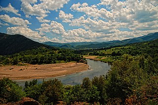
The Arda is a 290-kilometre-long (180 mi) river in Bulgaria and Greece. It is a tributary of the Maritsa. Its source lies in the Bulgarian Rhodope Mountains near the village Arda, part of the municipality of Smolyan. It flows eastward past Rudozem, Kardzhali and Ivaylovgrad and enters Greece in the northern part of the Evros regional unit. It flows into the Maritsa on the border of Greece and Turkey, between the Greek village Kastanies and the Turkish city Edirne. In the Bulgarian section, there are three hydroelectric and irrigation dams, Kardzhali Dam, Studen Kladenets and Ivaylovgrad Dam. The Bulgarian section is 229 kilometres (142 mi) long, making the Arda the longest river in the Rhodopes. The medieval Dyavolski most arch bridge crosses the river 10 kilometres (6 mi) from Ardino.

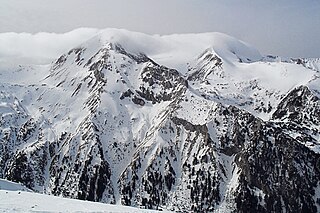
Rila is the highest mountain range of Bulgaria, the Balkan Peninsula, and Southeast Europe. It is situated in southwestern Bulgaria and forms part of the Rila–Rhodope Massif. The highest summit is Musala at an elevation of 2,925 m which makes Rila the sixth highest mountain range in Europe after the Caucasus, the Alps, Sierra Nevada, the Pyrenees and Mount Etna, and the highest one between the Alps and the Caucasus. It spans a territory of 2,629 km2 with an average elevation of 1487 m. The mountain is believed to have been named after the river of the same name, which comes from the Old Bulgarian verb "рыти" meaning "to grub".
The Pirin Mountains are a mountain range in southwestern Bulgaria, with the highest peak, Vihren, at an altitude of 2,914 m (9,560 ft).
Madan is a town in Smolyan Province, the very south of Bulgaria in the Yellow Share of the Rhodope Mountains. It is the administrative centre of the homonymous Madan Municipality. In 2019, the town had a population of 6,597.

The Varbitsa is a 98 km long river in the eastern Rhodope Mountains in southern Bulgaria. It is the longest and the largest tributary of the Arda, the main river of mountain range, itself a tributary of the Maritsa. The Varbitsa is Bulgaria's most temperamental river, with up to 5,000 times difference in water volume between spring highs and autumn lows, with frequent massive flooding and erosion as a result. Its middle and lower valley is considered the boundary between the western and the eastern Rhodopes.

The Chepelare river or Chepelarska reka is an 86 km-long river in the Rhodope Mountains of southern Bulgaria, a right tributary of the river Maritsa.

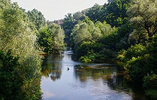
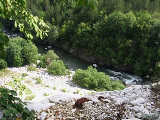
The Vacha is a river in southern Bulgaria, a right tributary of the river Maritsa. The 112 km long Vacha is the 23rd longest river of Bulgaria and the second longest in the Rhodope Mountains, following the Arda (272 km), another major Maritsa tributary. The Vacha drains significant area of the western Rhodope Mountains, including the ridges Batak Mountain, Veliyshko–Videnishki, Pereliksko–Prespanski and Chernatitsa.

Devin is a spa town in Smolyan Province in the far south of Bulgaria. It is the administrative centre of the homonymous Devin Municipality. As of December 2009, the town had a population of 7,054.
Zavalska Planina is a mountain range in Pernik Province, western Bulgaria, forming the westernmost part of the Zavalska–Plana chain of the Srednogorie mountain range system.
The Harmanliyska reka is a river in southern Bulgaria, a right tributary of the Maritsa. It is 92 km in length. The river drains the eastern slopes of the Mechkovets ridge, the northern slopes of the ridges Chukata and Huhla, and large areas of the Haskovo hills, all part of the Eastern Rhodope Mountains.
The Yugovska reka is a 45 km long river in southern Bulgaria, flowing through Smolyan and Plovdiv Provinces. It is a right tributary of the Chepelarska reka, itself a right tributary of the Maritsa.

Republican Road II-86 is a 2nd class road in Bulgaria, running in general direction north–south through the territory of Plovdiv and Smolyan Provinces. Its length is 147.4 km.

The Cherna is a 48 km long river in southern Bulgaria, a left tributary of the Arda of the Maritsa drainage.

The Aterenska reka is a river in southern Bulgaria and northeastern Greece, a right tributary of the Arda of the Maritsa drainage. Its length is 35 km, of which 20 km in Bulgarian territory.

The Malka Arda is a 41 km long river in southern Bulgaria, a left tributary of the Arda of the Maritsa drainage.

The Borovitsa is a 42 km long river in southern Bulgaria, a left tributary of the Arda of the Maritsa drainage. Along its low course and its tributary the Ayladere passes the boundary between the western and the eastern Rhodope Mountains.
The Perperek is a 44 km long river in southern Bulgaria, a left tributary of the Arda of the Maritsa drainage.

The Sushitsa is a 24 km long river in southern Bulgaria, flowing through Smolyan and Plovdiv Provinces. It is a right tributary of the Yugovska reka, itself a right tributary of the Chepelarska reka of the Maritsa basin.
