Related Research Articles
Felisburgo is a Brazilian municipality located in the northeast of the state of Minas Gerais.

Joaíma is a Brazilian municipality located in the northeast of the state of Minas Gerais.

Jordânia is a Brazilian municipality located in the northeast of the state of Minas Gerais. The city belongs to the mesoregion of Jequitinhonha and to the microregion of Almenara. As of 2020 the population was 10,842 in a total area of 549 km².

Palmópolis is a municipality in the northeast of the Brazilian state of Minas Gerais. Its population in 2020 was 5,349 inhabitants in a total area of 436 km².

Rubim is a municipality in the northeast of the Brazilian state of Minas Gerais. Its population in 2020 was 10,256 inhabitants in a total area of 969 km².
Santa Helena de Minas is a municipality in the northeast of the Brazilian state of Minas Gerais. As of 2020 the population was 6,386 in a total area of 277 square kilometres (107 sq mi). The elevation is 312 metres (1,024 ft). It became a municipality in 1997.

São João das Missões is a municipality in the north of the Brazilian state of Minas Gerais. As of 2020 the population was 13,125 in a total area of 675 km². The elevation is 501 meters. It became a municipality in 1997.

Botumirim is a Brazilian municipality located in the north of the state of Minas Gerais. In 2020 the population was 6,288 in a total area of 1,572 km2. The elevation is 948 meters. It became a municipality in 1962.

Josenópolis is a Brazilian municipality located in the north of the state of Minas Gerais. In 2020 the population was 4,889 in a total area of 536 km². It became a municipality in 1997.

Padre Carvalho is a Brazilian municipality located in the north of the state of Minas Gerais. In 2020 the population was 6,423 in a total area of 450 km². It became a municipality in 1997.

Ibiaí is a Brazilian municipality located in the north of the state of Minas Gerais. In 2020 the population was 8,437 in a total area of 870 km². It became a municipality in 1963.

Jequitaí is a Brazilian municipality located in the north of the state of Minas Gerais. In 2020 the population was 7,468 in a total area of 1,268 km2. It became a municipality in 1948.
São Romão is a Brazilian municipality located in the north of the state of Minas Gerais. In 2020 the population was 12,529 in a total area of 2,432 km². It became a municipality in 1943.
Lassance is a Brazilian municipality located in the north of the state of Minas Gerais. In 2020 the population was 6,503 in a total area of 3,213 km². It became a municipality in 1953.

Capinópolis is a municipality in the west of the Brazilian state of Minas Gerais. As of 2020 the population was 16,234 in a total area of 621 km². It became a municipality in 1953. The name means "city of grass".

Cruzeiro da Fortaleza is a Brazilian municipality located in the northwest of the state of Minas Gerais. Its population as of 2020 was 3,639 people living in a total area of 185 km2. The city belongs to the mesoregion of Triângulo Mineiro e Alto Paranaiba and to the microregion of Patrocínio. It became a municipality in 1963.

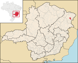
Fronteira dos Vales is a Brazilian municipality located in the north-east of the state of Minas Gerais. Its population as of 2020 was 4,561 living in a total area of 318 km2 (123 sq mi). The city belongs to the statistical mesoregion of Vale do Mucuri and to the statistical microregion of Nanuque. It became a municipality in 1963.

São Sebastião do Paraíso is a Brazilian municipality located in the southwest of the state of Minas Gerais. Its population as of 2020 was 71,445 people living in a total area of 822 km². The city belongs to the meso-region of Sul e Sudoeste de Minas and to the micro-region of São Sebastião do Paraíso. It became a municipality in 1870. The city and surrounding area are famous for the growing of high-quality coffee.
The Rubim do Norte River is a river of Minas Gerais state in southeastern Brazil.

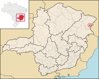
Nanuque is a municipality in the state of Minas Gerais, in the southeastern region of Brazil, belonging to Mucuri Valley and Region Nanuque. The relief consists of inselbergs and seas of hills, and the Serra dos Aimorés as predominant characteristic. Considered the 79th most populous city in the state, the 2nd Northeast 1st miner and its region, with 40,665 inhabitants according to the 2020 estimate. According to DENATRAN its fleet is 17,782 motor vehicles. As a regional hub ten municipalities, their total area 116,545 inhabitants and a total area of 8471.872 km ². Nanuque, cut the highway Ox (BR-418), reference is to be en route to the northern coast of Espirito Santo state by state highway LMG-719 and the southern coast of Bahia state by the then federal highway BR-418, of which is 605 km to the northeast of the state capital Belo Horizonte and 1257 km east of the federal capital Brasília.
References
- ↑ "Ministry of Transport" (PDF). Zonu. Retrieved 21 August 2014.
Coordinates: 16°07′06″S40°24′57″W / 16.1183°S 40.4159°W