Rudawka Rymanowska | |
---|---|
Village | |
Coordinates: 49°31′N21°56′E / 49.517°N 21.933°E | |
Country | |
Voivodeship | Subcarpathian |
County | Krosno County |
Gmina | Rymanów |
Elevation | 430 m (1,410 ft) |
Population | 40 |
Wikimedia Commons has media related to Rudawka Rymanowska . |
Rudawka Rymanowska [ruˈdafka rɨmaˈnɔfska] (Ukrainian : Рудавка Риманівська, Rudavka Rymanivs’ka) is a village in the administrative district of Gmina Rymanów, within Krosno County, Subcarpathian Voivodeship, in south-eastern Poland. It lies approximately 7 kilometres (4 mi) south-east of Rymanów, 23 km (14 mi) south-east of Krosno, and 58 km (36 mi) south of the regional capital Rzeszów. [1]
Ukrainian is an East Slavic language. It is the official state language of Ukraine and first of two principal languages of Ukrainians; it is one of the three official languages in the unrecognized state of Transnistria, the other two being Romanian and Russian. Written Ukrainian uses a variant of the Cyrillic script.
A village is a clustered human settlement or community, larger than a hamlet but smaller than a town, with a population ranging from a few hundred to a few thousand. Though villages are often located in rural areas, the term urban village is also applied to certain urban neighborhoods. Villages are normally permanent, with fixed dwellings; however, transient villages can occur. Further, the dwellings of a village are fairly close to one another, not scattered broadly over the landscape, as a dispersed settlement.
Gmina Rymanów is an urban-rural gmina in Krosno County, Subcarpathian Voivodeship, in south-eastern Poland. Its seat is the town of Rymanów, which lies approximately 17 kilometres (11 mi) south-east of Krosno and 53 km (33 mi) south of the regional capital Rzeszów.
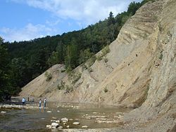
A small village situated in the northern part of Bukowskie Foothills over a picturesque gorge of the upper Wisłok River. A well-known part of John Paul II trail in the Low Beskid Mountains – Karol Wojtyła, the late Pope, took the trail six times during his summer vacations. Every year, on last Sunday of August, the town hosts the National Exposition of the Simmental Cattle and the Regional Championship of Hucul Horse.
The Pogórze Bukowskie is one of the Beskids mountain ranges of the Outer Eastern Carpathians in southeastern Poland, part of the Central Beskidian Piedmont. Is a hilly region in Poland, between Beskid Niski and Bieszczady near the river Osława and San. Its name comes from the west Slavic dialect word buk, meaning "beech".
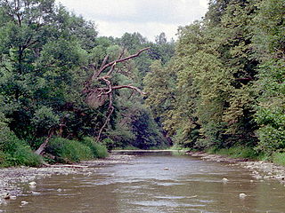
Wisłok is a river in south-eastern Poland, a tributary of the San River, with a length of 220 kilometres and a basin area of 3,538 km2. The root of the name Vis-lok is Indo-European or pre-Indo-European.
Gmina Dukla is an urban-rural gmina in Krosno County, Subcarpathian Voivodeship, in south-eastern Poland, on the Slovak border. Its seat is the town of Dukla, which lies approximately 14 kilometres (9 mi) south of Krosno and 57 km (35 mi) south-west of the regional capital Rzeszów.
Gmina Zarszyn is a rural gmina in Sanok County, Subcarpathian Voivodeship, in south-eastern Poland. Its seat is the village of Zarszyn, which lies approximately 15 kilometres (9 mi) west of Sanok and 50 km (31 mi) south of the regional capital Rzeszów.
Zawadka Rymanowska is a village in the administrative district of Gmina Dukla, within Krosno County, Subcarpathian Voivodeship, in south-eastern Poland, close to the border with Slovakia. It lies approximately 7 kilometres (4 mi) south-east of Dukla, 19 km (12 mi) south of Krosno, and 61 km (38 mi) south of the regional capital Rzeszów.
Dobieszyn is a village in the administrative district of Gmina Jedlicze, within Krosno County, Subcarpathian Voivodeship, in south-eastern Poland. It lies approximately 4 kilometres (2 mi) south-east of Jedlicze, 5 km (3 mi) west of Krosno, and 45 km (28 mi) south-west of the regional capital Rzeszów.
Bałucianka is a village in the administrative district of Gmina Rymanów, within Krosno County, Subcarpathian Voivodeship, in south-eastern Poland. It lies approximately 8 kilometres (5 mi) south-west of Rymanów, 18 km (11 mi) south of Krosno, and 58 km (36 mi) south of the regional capital Rzeszów.
Bzianka is a village in the administrative district of Gmina Rymanów, within Krosno County, Subcarpathian Voivodeship, in south-eastern Poland. It lies approximately 9 kilometres (6 mi) north-east of Rymanów, 15 km (9 mi) south-east of Krosno, and 45 km (28 mi) south of the regional capital Rzeszów.
Głębokie is a village in the administrative district of Gmina Rymanów, within Krosno County, Subcarpathian Voivodeship, in south-eastern Poland. It lies approximately 4 kilometres (2 mi) south-east of Rymanów, 20 km (12 mi) south-east of Krosno, and 55 km (34 mi) south of the regional capital Rzeszów.
Klimkówka is a village in the administrative district of Gmina Rymanów, within Krosno County, Subcarpathian Voivodeship, in south-eastern Poland. It lies approximately 5 kilometres (3 mi) north-west of Rymanów, 13 km (8 mi) south-east of Krosno, and 52 km (32 mi) south of the regional capital Rzeszów.
Królik Polski is a village in the administrative district of Gmina Rymanów, within Krosno County, Subcarpathian Voivodeship, in south-eastern Poland. It lies approximately 8 kilometres (5 mi) south-west of Rymanów, 20 km (12 mi) south of Krosno, and 59 km (37 mi) south of the regional capital Rzeszów.
Ladzin is a village in the administrative district of Gmina Rymanów, within Krosno County, Subcarpathian Voivodeship, in south-eastern Poland. It lies approximately 5 kilometres (3 mi) north of Rymanów, 13 km (8 mi) south-east of Krosno, and 49 km (30 mi) south of the regional capital Rzeszów.
Łazy is a village in the administrative district of Gmina Rymanów, within Krosno County, Subcarpathian Voivodeship, in south-eastern Poland. It lies approximately 3 kilometres (2 mi) north-east of Rymanów, 16 km (10 mi) south-east of Krosno, and 51 km (32 mi) south of the regional capital Rzeszów.
Milcza is a village in the administrative district of Gmina Rymanów, within Krosno County, Subcarpathian Voivodeship, in south-eastern Poland. It lies approximately 7 kilometres (4 mi) north-east of Rymanów, 15 km (9 mi) south-east of Krosno, and 47 km (29 mi) south of the regional capital Rzeszów.
Posada Górna is a village in the administrative district of Gmina Rymanów, within Krosno County, Subcarpathian Voivodeship, in south-eastern Poland. It lies approximately 2 kilometres (1 mi) west of Rymanów, 16 km (10 mi) south-east of Krosno, and 53 km (33 mi) south of the regional capital Rzeszów.
Puławy is a village in the administrative district of Gmina Rymanów, within Krosno County, Subcarpathian Voivodeship, in south-eastern Poland. It lies approximately 6 kilometres (4 mi) south of Rymanów, 22 km (14 mi) south-east of Krosno, and 58 km (36 mi) south of the regional capital Rzeszów.
Sieniawa is a village in the administrative district of Gmina Rymanów, within Krosno County, Podkarpackie Province, in south-eastern Poland. It lies approximately 4 kilometres (2 mi) south-east of Rymanów, 20 km (12 mi) south-east of Krosno, and 54 km (34 mi) south of the regional capital Rzeszów.
Wisłoczek is a village in the administrative district of Gmina Rymanów, within Krosno County, Subcarpathian Voivodeship, in south-eastern Poland. It lies approximately 6 km (4 mi) south of Rymanów, 21 km (13 mi) south-east of Krosno, and 59 km (37 mi) south of the regional capital Rzeszów.
Wróblik Królewski is a village in the administrative district of Gmina Rymanów, within Krosno County, Subcarpathian Voivodeship, in south-eastern Poland. It lies approximately 6 kilometres (4 mi) north of Rymanów, 12 km (7 mi) south-east of Krosno, and 48 km (30 mi) south of the regional capital Rzeszów.
Wróblik Szlachecki is a village in the administrative district of Gmina Rymanów, within Krosno County, Subcarpathian Voivodeship, in south-eastern Poland. It lies approximately 6 kilometres (4 mi) north of Rymanów, 13 km (8 mi) south-east of Krosno, and 48 km (30 mi) south of the regional capital Rzeszów.
Coordinates: 49°31′N21°56′E / 49.517°N 21.933°E
A geographic coordinate system is a coordinate system that enables every location on Earth to be specified by a set of numbers, letters or symbols. The coordinates are often chosen such that one of the numbers represents a vertical position and two or three of the numbers represent a horizontal position; alternatively, a geographic position may be expressed in a combined three-dimensional Cartesian vector. A common choice of coordinates is latitude, longitude and elevation. To specify a location on a plane requires a map projection.
This Krosno County location article is a stub. You can help Wikipedia by expanding it. |