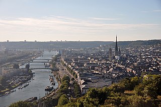
Rouen is a city on the River Seine in northern France. It is the prefecture of the region of Normandy and the department of Seine-Maritime. Formerly one of the largest and most prosperous cities of medieval Europe, the population of the metropolitan area is 702,945 (2018). People from Rouen are known as Rouennais.

Place Charles de Gaulle, historically known as the Place de l'Étoile, is a large road junction in Paris, France, the meeting point of twelve straight avenues including the Champs-Élysées. It was renamed in 1970, following the death of President Charles de Gaulle. It is still often referred to by its original name; the nearby Métro and RER station retains the designation Charles de Gaulle–Étoile. Paris's Axe historique cuts through the Arc de Triomphe, which stands at the centre of Place Charles de Gaulle.

The Rue du Faubourg Saint-Honoré is a street located in the 8th arrondissement of Paris, France. Relatively narrow and nondescript, especially in comparison to the nearby Avenue des Champs-Élysées, it is cited as being one of the most luxurious and fashionable streets in the world thanks to the presence of virtually every major global fashion house, the Élysée Palace, the Hôtel de Pontalba, the Embassy of Canada, the Embassy of the United Kingdom, as well as numerous art galleries.
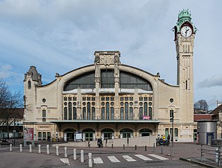
Rouen-Rive-Droite is a large railway station serving the city of Rouen, Normandy, France. The station is on Rue Verte in the north of the city. Services are mainly intercity but many services are local. There are also TGV from Le Havre to Marseille-Saint-Charles.
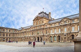
The Louvre Palace, often referred to simply as the Louvre, is an iconic French palace located on the Right Bank of the Seine in Paris, occupying a vast expanse of land between the Tuileries Gardens and the church of Saint-Germain l'Auxerrois. Originally a military facility, it has served numerous government-related functions in the past, including intermittently as a royal residence between the 14th and 18th centuries. It is now mostly used by the Louvre Museum, which first opened there in 1793.

The rue Saint-Honoré is a street in the 1st arrondissement of Paris, France.
The Rue de Richelieu is a long street of Paris, starting in the south of the 1st arrondissement at the Comédie-Française and ending in the north of the 2nd arrondissement. For the first half of the 19th century, before Georges-Eugène Haussmann redefined Paris with grand boulevards, it was one of the most fashionable streets of Paris.
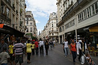
Rue Saint-Denis is one of the oldest streets in Paris. Its route was first laid out in the 1st century by the Romans, and then extended to the north in the Middle Ages. From the Middle Ages to the present day, the street has been notorious as a place of prostitution. Its name derives from it being the historic route to Saint-Denis.

The Pavillon de l’Horloge, also known as the Pavillon Sully, is a prominent architectural structure located in the center of the western wing of the Cour Carrée of the Palais du Louvre in Paris. Since the late 19th century, the name Pavillon de l'Horloge has generally been applied to the structure's eastern face, which dates from the 17th century, and the name Pavillon Sully to its western face, which was redecorated in the 1850s as part of Napoleon III's Louvre expansion.
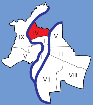
The 4th arrondissement of Lyon is one of the nine arrondissements of the City of Lyon.

Rue Victor-Hugo is a pedestrian street in the 2nd arrondissement of Lyon, in the Ainay district of the Presqu'île quarter, reputed to be one of the most known shopping area of Lyon. From north to south, it connects the Place Bellecour to the Place Carnot. Beyond the Place Bellecour, the rue de la République is its natural extension, thus creating one of the biggest pedestrian streets in Europe. The street is served by metro stations Perrache, Bellecour and Ampère - Victor Hugo. It belongs to the zone classified as World Heritage Site by UNESCO.
The Rue de la Poulaillerie is a street located in the 2nd arrondissement of Lyon, France. It was first named rue Vaudran, and also rue Maudite in reference to Peter Waldo, who founded what was considered a heresy at the time, the street received its current name from the fact that people exchanged poultry until 1835, when part of this trade emigrated to the covered market of La Martinière.
The rue Sainte-Catherine is a very old street at the foot of the slopes of La Croix-Rousse quarter, in the 1st arrondissement of Lyon. It is particularly known for being a drinking street. The street belongs to the zone classified as World Heritage Site by UNESCO.
The Montée de la Grande Côte, or the Montée de la Grande-Côte, is a street of La Croix-Rousse quarter, in the 1st arrondissement of Lyon, which connects the Terreaux quarter and the Plateau de la Croix Rousse. It is characterized by a high elevation and is more narrow at the bottom. The street belongs to the zone that is classified as World Heritage Site by UNESCO.

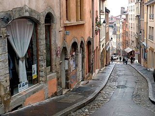
The Rue de Gadagne is a paved pedestrian street of the Saint-Jean quarter, in the 5th arrondissement of Lyon. It extends the rue du Bœuf and ends on the rue Lainerie that leads itself to the Place Saint-Paul. It is located in the center of Vieux Lyon and is part to the area which includes a mosaic of squares : Place du Change, Place du Petit Collège and Place de la Baleine in the extension of rue Saint-Jean. The street belongs to the zone classified as World Heritage Site by UNESCO. It is served by buses 29-30-31-44-184, a metro station and three velo'v stations.

The Rue du Sergent Blandan is one of the oldest streets of Lyon. It connects Saint Vincent and the slopes of the Croix-Rousse quarters, in the 1st arrondissement of Lyon. The street starts at rue Pareille, runs along the Place Sathonay, crosses the rue Hippolyte Flandrin, the rue Louis Vitet and the rue du Terme, and becomes the rue des Capucins just after the square of the same name. The street belongs to the zone classified World Heritage Site by UNESCO. It is named in honour of Sergent Blandan, who participated in the conquest of Algeria.
There have been two separate generations of trams in Rouen. The first generation tramway was a tram network built in Rouen, Normandy, northern France, that started service in 1877, and finally closed in 1953. There were no trams at all in Rouen between 1953 and 1994, when the modern Rouen tramway opened.
The Rue Nationale is one of the oldest streets and the busiest shopping street in the city of Tours.
Polyclès Langlois was a French writer, draughtsman and painter.

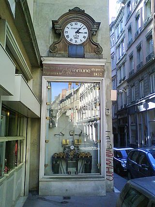
The Gros-Horloge is a 14th century astronomical clock in Rouen, Normandy.

