
The Rhaetian Railway, abbreviated RhB, is a Swiss transport company that owns the largest network of all private railway operators in Switzerland. Headquartered in Chur, the RhB operates all the railway lines of the Swiss canton of Grisons, except for the line from Sargans to the cantonal capital, Chur, which are operated by Swiss Federal Railways (SBB CFF FFS), as well as the line from Disentis/Mustér to the Oberalp Pass and further on to Andermatt, Uri, which is operated by Matterhorn Gotthard Bahn (MGB). Inaugurated in 1888 and expanded from 1896 onwards in various sections, the RhB network is located almost entirely within Grisons, with one station across the Italian border at Tirano.

Reichenau is a village in the municipality of Tamins in the Canton of Graubünden, Switzerland, where the two Rhine tributaries Vorderrhein and Hinterrhein meet, forming the Alpine Rhine.

The Glacier Express is a direct train connecting railway stations of the two major mountain resorts of Zermatt and St. Moritz via Andermatt in the central Swiss Alps. The train provides a one-seat ride for an 8-hour end-to-end 291 km journey, and omits stops made by local trains. The Glacier Express has been called the 'slowest express train in the world'. As St. Moritz and Zermatt are home to two well-known mountains, the Glacier Express is also said to travel from Matterhorn to Piz Bernina.

The Vorderrhein is one of the two sources of the Rhine. Its catchment area of 1,512 square kilometres is located predominantly in the canton of Graubünden,Switzerland. The Vorderrhein is about 76 kilometres (47 mi) long, thus more than 5% longer than the Hinterrhein. The Vorderrhein, however, has an average water flow of 53.8 m3/s (1,900 cu ft/s), which is less than the flow of the Hinterrhein. According to the Atlas of Switzerland of the Swiss Federal Office of Topography, the source of the Vorderrhein—and thus of the Rhine—is located north of the Rein da Tuma and Lake Toma.

Safiental is a municipality in the Surselva Region in the canton of Graubünden in Switzerland. The municipalities of Valendas, Versam, Safien and Tenna merged on 1 January 2013 into the new municipality of Safiental.

Valendas is a former municipality in the district of Surselva in the canton of Graubünden in Switzerland. The municipalities of Valendas, Versam, Safien and Tenna merged on 1 January 2013 into the new municipality of Safiental.
Versam is a former municipality in the district of Surselva in the canton of Graubünden in Switzerland. The municipalities of Valendas, Versam, Safien and Tenna merged on 1 January 2013 into the new municipality of Safiental.

Trin railway station is a station on the Reichenau-Tamins–Disentis/Mustér of the Rhaetian Railway in the Swiss canton of Graubünden. It is situated alongside the Anterior Rhine, in the railway's scenic passage through the Ruinaulta or Rhine Gorge. The station is located on the north bank of the river in the municipality of Trin, although the village of Trin lies about 3 kilometres (1.9 mi) to the north and some 250 metres (820 ft) higher than the station.

Versam-Safien railway station is a station on the Reichenau-Tamins–Disentis/Mustér railway of the Rhaetian Railway in the Swiss canton of Graubünden. It is situated alongside the Anterior Rhine, in the railway's scenic passage through the Ruinaulta or Rhine Gorge. The station is located on the south bank of the river in the municipality of Safiental, and serves the village of Versam that lies some 3.6 km (2.2 mi) to the south and some 250 metres (820 ft) higher than the station.

Valendas-Sagogn railway station is a station on the Reichenau-Tamins–Disentis/Mustér railway of the Rhaetian Railway in the Swiss canton of Graubünden. It is situated alongside the Anterior Rhine, and marks the upstream end of the railway's scenic passage through the Ruinaulta or Rhine Gorge. The station is located on the south bank of the river in the municipality of Safiental, and serves the villages of Valendas and Sagogn, which lie at higher elevations on either side of the gorge.

Castrisch railway station is a railway station on the Reichenau-Tamins–Disentis/Mustér railway of the Rhaetian Railway in the Swiss canton of Graubünden. It serves the village of Castrisch in the municipality of Ilanz/Glion.

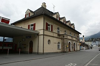
Ilanz railway station is a railway station in the municipality of Ilanz/Glion, in the Swiss canton of Graubünden. It is an intermediate stop on the 1,000 mm gauge Reichenau-Tamins–Disentis/Mustér line of the Rhaetian Railway.

Rueun railway station is a station on the Reichenau-Tamins–Disentis/Mustér railway of the Rhaetian Railway in the Swiss canton of Graubünden. It serves the village of Rueun, in the municipality of Ilanz/Glion.

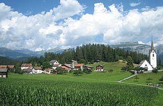
Waltensburg/Vuorz railway station is a station on the Reichenau-Tamins–Disentis/Mustér railway of the Rhaetian Railway in the Swiss canton of Graubünden. It serves the village of Waltensburg/Vuorz in the municipality of Breil/Brigels.
Disentis/Mustér railway station is the eastern terminus of the Matterhorn Gotthard Bahn line from Brig via Andermatt, and the western terminus of the Rhaetian Railway line from Landquart via Chur and Reichenau-Tamins. The station is located on the south bank of the river in the village and municipality of Disentis/Mustér, in the Swiss canton of Graubünden.

The Flims rockslide happened about 10,000 years ago in eastern Switzerland. It is the largest known landslide in the Alps, and the biggest worldwide whose effects are still visible, moving some 12 km3 (2.9 cu mi) of rock, about 300 times that of the historic Swiss Goldau landslide. The town of Flims can be found at the line where the slip surface disappears under the debris. North of Flims the rock face of Flimserstein stands 350 metres (1,148 ft) high whereas more westerly the slide surface is clearly visible. South of Flims is a huge hilly debris area that has been forest ever since, as this area is not suitable for farming, firstly for its shape and, even more for its lack of water. The river Rhine crosses this debris in a gorge called Ruinaulta. The Rhine still runs in debris, which shows that it has not yet reached the level it had before the incident. The highest hill in the debris area is almost 200 metres (656 ft) higher than Flims at the end of the sliding surface.

Il Spir is a viewing platform at Conn, a location near Flims in the canton of Graubünden in Switzerland.

The Rabiusa is a 32 km long tributary of the Rhine. The river originates in the district Hinterrhein in the canton of Graubünden, in the mountains surrounding the Bärenhorn, where the old bridle path from Safien to Splügen crosses the Safierberg Pass. It then flows through the wooded Safien valley and into the rough Versam Gorge, where it is spanned by the Versam Gorge Bridge. The confluence with the Anterior Rhine is located in the equally deep Ruinaulta.
Surselva Region is one of the eleven administrative districts in the canton of Graubünden in Switzerland. It was created on 1 January 2017 as part of a reorganization of the canton.

The Reichenau-Tamins–Disentis/Mustér railway is a Swiss metre-gauge railway, which is operated by the Rhaetian Railway. It connects the stations of Reichenau-Tamins and Disentis/Mustér.


