
Ruston is a city in Pierce County, Washington, United States. The population was 1,055 at the 2020 census.
Tacoma is the county seat of Pierce County, Washington, United States. A port city, it is situated along Washington's Puget Sound, 32 miles (51 km) southwest of Seattle, 36 miles (58 km) southwest of Bellevue, 31 miles (50 km) northeast of the state capital, Olympia, 58 miles (93 km) northwest of Mount Rainier National Park, and 80 miles (130 km) east of Olympic National Park. The city's population was 219,346 at the time of the 2020 census. Tacoma is the second-largest city in the Puget Sound area and the third-most populous in the state. Tacoma also serves as the center of business activity for the South Sound region, which has a population of about 1 million.

Harbourfront is a neighbourhood on the northern shore of Lake Ontario within the downtown core of the city of Toronto, Ontario, Canada. Part of the Toronto waterfront, Harbourfront extends from Bathurst Street in the west, along Queens Quay, with its ill-defined eastern boundary being either Yonge Street or York Street. Its northern boundary is the Gardiner Expressway. Much of the district was former water lots filled in during the early 1900s to create a larger harbour district. After shipping patterns changed and the use of the Toronto harbour declined, the area was converted from industrial uses to a mixed-use district that is mostly residential and leisure.
The Neponset River is a river in eastern Massachusetts in the United States. Its headwaters are at the Neponset Reservoir in Foxborough, near Gillette Stadium. From there, the Neponset meanders generally northeast for about 29 miles (47 km) to its mouth at Dorchester Bay between Quincy and the Dorchester section of Boston, near the painted gas tank.

Point Defiance Park in Tacoma, Washington, United States, is a large urban park. The 760-acre (3.1 km2) park includes Point Defiance Zoo & Aquarium, the Rose Garden, Rhododendron Garden, beaches, trails, a boardwalk, a boathouse, a Washington State Ferries ferry dock for the Point Defiance-Tahlequah route to Vashon Island, Fort Nisqually, an off-leash dog park, and most notably about 400 acres of old-growth forest. It receives more than three million visitors every year. Point Defiance Park is maintained and operated by Metro Parks Tacoma.

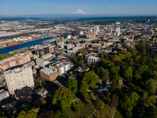
North Tacoma is a neighborhood in Tacoma, Washington, in the United States. The area is most known for waterfront parks and restaurants, Point Defiance Park, the University of Puget Sound, Stadium High School, and the Tacoma Narrows Bridge.
Old Tacoma is a neighborhood of the north end of Tacoma, Washington, more commonly known as Old Town.
City of Parks is a municipal project to create a continuous paved pedestrian and biking trail around the city of Louisville, Kentucky while also adding a large amount of park land. The project was announced on February 22, 2005. Current plans call for making approximately 4,000 acres (1,600 ha) of the Floyds Fork floodplain in eastern Jefferson County into park space, expanding area in the Jefferson Memorial Forest, and adding riverfront land and wharfs along the Riverwalk Trail and Levee Trail. There are also plans to connect the 100-mile (160 km) Louisville trail to a planned seven mile (11 km) trail connecting the Southern Indiana cities of New Albany, Clarksville and Jeffersonville.
India Basin is a neighborhood, named after the body of water, in the southeastern part of San Francisco, California, considered to be part of the larger Bayview–Hunters Point neighborhood.

Dunn State Park is a public recreation area surrounding a 20-acre (8.1 ha) pond in Gardner, Massachusetts. The state park covers 132 acres (53 ha) and is managed by the Department of Conservation and Recreation.
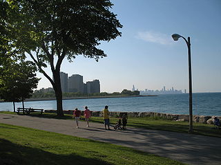
Burnham Park is a public park located in Chicago, Illinois. Situated along 6 miles (9.7 km) of Lake Michigan shoreline, the park connects Grant Park at 14th Street to Jackson Park at 56th Street. The 598 acres (242 ha) of parkland is owned and managed by the Chicago Park District. It was named for urban planner and architect Daniel Burnham in 1927. Burnham was one of the designers of the 1893 World's Columbian Exposition.
The Tacoma riot of 1885, also known as the 1885 Chinese expulsion from Tacoma, involved the forceful expulsion of the Chinese population from Tacoma, Washington Territory, on November 3, 1885. City leaders had earlier proposed a November 1 deadline for the Chinese population to leave the city. On November 3, 1885, a mob that consisted of prominent businessmen, police, and political leaders descended on the Chinese community. The mob marched Chinese residents to a railroad station and forced them to board a train to Portland. In the following days, the structures that remained in the Chinese community were razed. The event was the result of growing anti-Chinese sentiment and violence throughout the American West.

The Port of Tacoma is an independent seaport located in Tacoma, Washington. The port was created by a vote of Pierce County citizens on November 5, 1918. The Edmore was the first ship to call at the port in 1921. The port's marine cargo operations, among the largest in the United States, was merged with the Port of Seattle's in 2015 to form the Northwest Seaport Alliance.

Ferry Point Park is a 413.8-acre (167.5 ha) park in the Bronx, New York City. The park site is a peninsula projecting into the East River roughly opposite the College Point and Malba neighborhoods of Queens. The park is located on the eastern shore of Westchester Creek, adjacent to the neighborhood of Throggs Neck. The park is operated by the New York City Department of Parks and Recreation. The Hutchinson River Expressway crosses the park to the Bronx-Whitestone Bridge, splitting it into east and west sides.

Curtis Hixon Waterfront Park is an 8 acres (3.2 ha) public park located along the Hillsborough river in downtown Tampa, Florida that opened in its current configuration in 2010. It is adjacent to the Tampa Riverwalk, Florida Museum of Photographic Arts, Tampa Museum of Art, Glazer Children's Museum, and Rivergate Tower. The park overlooks the University of Tampa's Plant Hall, which is directly across the river. The park is in an area known as the Waterfront Arts District.

Echo Bay is an embayment located off Long Island Sound in the city of New Rochelle in Westchester County, New York. It is an anchorage for small craft and is generally fully occupied during the summer. The depths at the anchorage range from 4 to 15 feet, and launches can anchor in the shallow cove on the northeast side of the harbor, entering between Harrison Islands and the rocky, grassy islet off the northwest side of Echo Island. Vessels frequently anchor between the entrance of Echo Bay and Hicks Ledge, in depths of 20 to 24 feet. On the northwest side of Echo Bay a dredged channel 100 feet wide and 15 feet deep, marked by buoys, leads to the New Rochelle Municipal Marina at Beaufort Point.
Davenport Neck is a peninsula in New Rochelle, New York, extending southwesterly from the mainland into Long Island Sound, and running parallel to the main shore. It divides the city's waterfront into two, with New Rochelle Harbor to the south and southwest, and Echo Bay, to the north and northeast. Glen Island and Neptune Island lie just to the west of the Neck, and Davids and Huckleberry islands lie to the south.
Pelham Road, known as Shore Road within the Bronx, is a historic 4.1-mile (6.6 km) east-west road that runs along the Long Island Sound shoreline from Pelham Bay Park in the Bronx through the southern Westchester County, New York communities of New Rochelle and Pelham Manor. The thoroughfare had its beginning as a Native American trail linking the important villages on Davenport Neck to those on Pelham Neck in Pelham. Between these points along the shore line there was an almost continuous chain of small Indian villages and camps. This waterfront area was especially advantageous, with many small coves in secure harbors and protected by adjacent islands and many small streams of water and abundant springs.

Mission Historical Park is a 10-acre park (4.0 ha) located to the east of the Santa Barbara Mission in Santa Barbara, California. The park hosts a large open grassy area, the A.C. Postel Memorial Rose Garden, a fountain, hiking trails, a variety of sycamore and native oak trees, a historic olive grove dedicated to World War I veterans, remains of tannery vats, a pottery, gristmill, and a historic reservoir and aqueduct system. The park and the Mission were designated as a California State Historical Landmark on July 12, 1939.
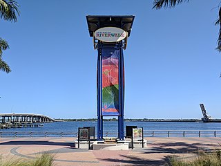
Bradenton Riverwalk is a 1.5-mile-long (2.4 km) public green space located along the Manatee River in Bradenton, Florida, between Business US 41 and South Tamiami Trail. The five-acre (2.0 ha) park opened to the public on October 18, 2012 and features a skatepark, 400-seat amphitheater, playgrounds, and a splash pad. The area is maintained by the city of Bradenton and the nonprofit organization Realize Bradenton.