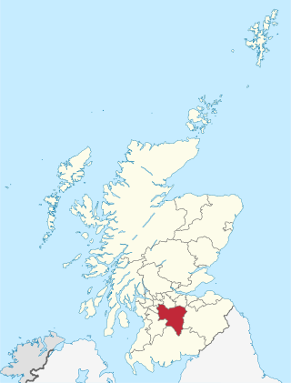
South Lanarkshire is one of 32 unitary authorities of Scotland. It borders the south-east of the Glasgow City council area and contains some of Greater Glasgow's suburban towns, as well as many rural towns and villages. It also shares borders with Dumfries and Galloway, East Ayrshire, East Renfrewshire, North Lanarkshire, the Scottish Borders and West Lothian. It includes most of the historic county of Lanarkshire.

Lanarkshire, also called the County of Lanark, is a historic county, lieutenancy area and registration county in the Central Lowlands and Southern Uplands of Scotland. The county is no longer used for local government purposes, but gives its name to the two modern council areas of North Lanarkshire and South Lanarkshire.

Rutherglen is a town in South Lanarkshire, Scotland, immediately south-east of the city of Glasgow, three miles from its centre and directly south of the River Clyde. Having previously existed as a separate Lanarkshire burgh, in 1975 Rutherglen lost its own local council and administratively became a component of the City of Glasgow District within the Strathclyde region. In 1996 the towns were reallocated to the South Lanarkshire council area.

Cambuslang is a town on the south-eastern outskirts of Greater Glasgow, Scotland. With approximately 30,000 residents, it is the 27th largest town in Scotland by population, although, never having had a town hall, it may also be considered the largest village in Scotland. It is within the local authority area of South Lanarkshire and directly borders the town of Rutherglen to the west. Historically, it was a large civil parish incorporating the nearby hamlets of Newton, Flemington, Westburn and Halfway.
Rutherglen and Hamilton West was a burgh constituency of the House of Commons of the Parliament of the United Kingdom, which was created for the 2005 general election. It covered almost all of the former constituency of Glasgow Rutherglen and most of the former constituency of Hamilton South, and it elected one member of parliament (MP) by the first-past-the-post voting system.

Burnside is a mostly residential area in the town of Rutherglen in South Lanarkshire, Scotland. Including the neighbourhoods of High Burnside and High Crosshill, respectively south and north-west of its main street, it borders Overtoun Park in Rutherglen plus several other residential areas of the town, as well as western parts of neighbouring Cambuslang.

Trinity High School is a Roman Catholic secondary school located in Eastfield, Rutherglen, Scotland near the city of Glasgow. It was established in 1971. The current head teacher is Allison Craig who took office in 2021 following the retirement of Peter Bollen.

Stonelaw High School is a non-denominational state high school located in Rutherglen, Scotland near the city of Glasgow.

Gilbertfield Castle is a ruined 17th-century castle in South Lanarkshire, Scotland. It is located at NS652587, on the north slope of Dechmont Hill, just outside Cambuslang, to the south-east of Glasgow.

The A730 road in Scotland runs between the centre of Glasgow and the south-eastern edge of the city's urban area at Cathkin.

The Cuningar Loop is a meander on the River Clyde in Scotland which was converted to a woodland park in the mid-2010s. It lies within the territory of Rutherglen, South Lanarkshire, directly east of the district of Dalmarnock in Glasgow.

Cathkin High School is a state secondary school in Cambuslang, South Lanarkshire, Scotland.

The City of Glasgow was a local government district in the Strathclyde region of Scotland from 1975 to 1996.
Farme Castle was located in Rutherglen, to the south-east of Glasgow, Scotland. It stood 0.5 miles (0.80 km) east of Farme Cross where the A724 meets the A749 trunk road. The castle keep acted as one corner of a courtyard, formed by an extension in the form of a castellated mansion. High walls and subsidiary buildings completed the courtyard. There was an ornate arched gateway to the courtyard adjacent to the keep. The old keep was of three storeys and a garret, above a corbelled-out parapet with machicolations and water spouts.

The A749 road in Scotland connects East Kilbride with Glasgow city centre via Rutherglen and Bridgeton.

Halfway is a largely suburban area in the town of Cambuslang, Scotland, located within the local authority area of South Lanarkshire. It borders the smaller areas of Lightburn, Cairns, Flemington, Drumsagard and Hallside.

Sir John Menteith of Ruskie and Knapdale was a Scottish nobleman during the Wars of Scottish Independence. He is known for his capture of Sir William Wallace in 1305 and later joined with King Robert I of Scotland and received large land grants in Knapdale and Kintyre for his service. He is described as "guardian" of the Earldom of Menteith, as his great-nephew Alan II, Earl of Menteith was a minor at the time of the death of Alan I, Earl of Menteith.

Castlemilk House was a country house located in what is now the Castlemilk district of Glasgow, Scotland. The house was the ancestral home of the Stirling-Stuart family and was built around the 15th-century Cassiltoun Tower during the 18th and 19th centuries. The house and Castlemilk Estate were purchased by Glasgow Corporation in 1938, with the house serving as a children's home until it was closed in 1969 and demolished in 1972.
Cambuslang Hibernian F.C., also known as the Cambuslang Hibs, was a football club based in the town of Cambuslang, Scotland which was originally founded in 1884. They competed in regional competitions and the Scottish Cup during the 1880s before dissolving in 1889 after being expelled from the Scottish Football Association over a payments dispute. They reformed in 1892 as a Scottish Junior Football Association club, and won the Scottish Junior Cup in 1896. Overlooked for a place in some of the more lucrative competitions organised over the next decade, they became defunct in 1908.

The A724 road in Scotland runs within South Lanarkshire between Rutherglen and Hamilton. It follows an ancient route which is marked on William Roy's Lowland Map of Scotland (1755) with only minor deviations from its modern course.

