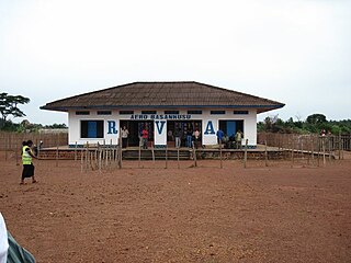
Basankusu Airstrip is an airport serving Basankusu, a city on the Lulonga River in Équateur Province, Democratic Republic of the Congo.

Mara Serena Airport is an airstrip in Masai Mara, Kenya.
Osubi Airstrip is an aviation facility located in Osubi, within Okpe Local Government, serving the city of Effurun, Warri and its environs in Delta State, Nigeria. It is about 10 kilometres (6.2 mi) northeast of the city.
Carnot Airport is an airstrip serving Carnot, a city in the Mambéré-Kadéï prefecture of the Central African Republic. The runway is on the western edge of the city.
Gordil Airport is an airstrip serving Gordil, a village in the Vakaga prefecture of the Central African Republic. The airstrip is 5 kilometres (3.1 mi) southeast of Gordil alongside the RN8 road in the northern part of Manovo-Gounda St. Floris National Park.
Ouanda Djallé Airport is an airstrip serving Ouanda Djallé, a village in the Vakaga prefecture of the Central African Republic. The airstrip lies alongside the RN5 road that runs northwest out of the village.
Sibut Airport is an airstrip serving Sibut, a city in the Kémo prefecture of the Central African Republic. The airstrip is 2 kilometres (1.2 mi) southwest of the town. It was built after January 2014 and replaces a long closed airport east of Sibut.
Baigua Airport was an agricultural airstrip near the hamlet of Baigue, in the La Altagracia Province of the Dominican Republic. Baigue is 7 kilometres (4.3 mi) southeast of Higüey.
Bongor Airport is an airport serving the city of Bongor, in the Mayo-Kebbi Est Region of Chad.
Kajo Keji is an airstrip serving the town of Kajo Keji, in South Sudan.

Hector Silva airstrip is an airport located in Cayo District serving Belmopan, the capital city of Belize. The runway is on the northern edge of the city off the George Price Highway, and has a small terminal building.
Homa Bay Airport, also known as Kabunde Airstrip, is an airport located 6 km (3.7 mi) from the town of Homa Bay in Homa Bay County, Kenya. It was modernised in 2015 and received its first commercial flights in January 2016.
Kirundo Airport is an airstrip serving the city of Kirundo, Burundi. The airstrip is 4 kilometres (2.5 mi) north of Kirundo, on the north shore of Lake Rwihinda.
Uaxactun Airport is an airstrip in the village of Uaxactun, Guatemala.
Gamboula Airport is an airstrip serving Gamboula, a town in the Mambéré-Kadéï prefecture of the Central African Republic. The airstrip is 3 kilometres (2 mi) northeast of the town, alongside the RN6 road.
Chaitén Airfield was an airport serving Chaitén, a town in the Los Lagos Region of Chile. The airport was damaged and closed after the 2008 eruption of Chaitén Volcano.
Corazón de Jesús Airport is an airstrip serving Corazón de Jesús and Narganá, island towns in the Guna Yala comarca of Panama.
Ailigandí Airport is an airstrip serving Ailigandí, an island town in the Guna Yala comarca of Panama. The airstrip is onshore, approximately 400 metres (1,312 ft) southeast of Ailigandí island and is reached by boat. There are no roads near the airstrip.
Esquipulas Airport is an airstrip serving the city of Esquipulas in Chiquimula Department, Guatemala.
Bugungu Airstrip is an airport serving the Bugungu Wildlife Reserve in the Murchison Falls National Park (MFNP), in Western Region of Uganda.


