
Gower or the Gower Peninsula in southwest Wales, projects towards the Bristol Channel. It is the most westerly part of the historic county of Glamorgan. In 1956, the majority of Gower became the first area in the United Kingdom to be designated an Area of Outstanding Natural Beauty.

The Red Lady of Paviland is an Upper Paleolithic partial skeleton of a male dyed in red ochre and buried in Wales 33,000 BP. The bones were discovered in 1823 by William Buckland in an archaeological dig at Goat's Hole Cave – one of the limestone caves between Port Eynon and Rhossili on the Gower Peninsula, Swansea, south Wales.

There are three related types of Neolithic earthwork that are all sometimes loosely called henges. The essential characteristic of all three is that they feature a ring-shaped bank and ditch, with the ditch inside the bank. Because the internal ditches would have served defensive purposes poorly, henges are not considered to have been defensive constructions. The three henge types are as follows, with the figure in brackets being the approximate diameter of the central flat area:
- Henge. The word henge refers to a particular type of earthwork of the Neolithic period, typically consisting of a roughly circular or oval-shaped bank with an internal ditch surrounding a central flat area of more than 20 m (66 ft) in diameter. There is typically little if any evidence of occupation in a henge, although they may contain ritual structures such as stone circles, timber circles and coves. Henge monument is sometimes used as a synonym for henge. Henges sometimes, but by no means always, featured stone or timber circles, and circle henge is sometimes used to describe these structures. The three largest stone circles in Britain are each within a henge. Examples of henges without significant internal monuments are the three henges of Thornborough Henges. Although having given its name to the word henge, Stonehenge is atypical in that the ditch is outside the main earthwork bank.
- Hengiform monument. Like an ordinary henge, except the central flat area is between 5 and 20 m (16–66 ft) in diameter, they comprise a modest earthwork with a fairly wide outer bank. The terms Mini henge or Dorchester henge are sometimes used as synonyms for hengiform monument. An example is the Neolithic site at Wormy Hillock Henge.
- Henge enclosure. A Neolithic ring earthwork with the ditch inside the bank, with the central flat area having abundant evidence of occupation and usually being more than 300 m (980 ft) in diameter. Some true henges are as large as this, but lack evidence of domestic occupation. Super henge is sometimes used as a synonym for a henge enclosure. However, sometimes Super henge is used to indicate size alone rather than use, e.g. "Marden henge ... is the least understood of the four British 'superhenges' ".

The Plain of Jars is a megalithic archaeological landscape in Laos. It consists of thousands of stone jars scattered around the upland valleys and the lower foothills of the central plain of the Xiangkhoang Plateau. The jars are arranged in clusters ranging in number from one to several hundred.

The Creswellian is a British Upper Palaeolithic culture named after the type site of Creswell Crags in Derbyshire by Dorothy Garrod in 1926. It is also known as the British Late Magdalenian. According to Andreas Maier: "In current research, the Creswellian and Hamburgian are considered to be independent but closely related entities which are rooted in the Magdalenian." The Creswellian is dated between 13,000 and 11,800 BP and was followed by the most recent ice age, the Younger Dryas, when Britain was at times unoccupied by humans.
Kirkdale Cave is a cave and fossil site located in Kirkdale near Kirkbymoorside in the Vale of Pickering, North Yorkshire, England. The cave was discovered by workmen in 1821, and was found to contain fossilized bones of a variety of mammals not currently found in Great Britain, including hippopotamus, elephant, and the remains of numerous cave hyenas. William Buckland analyzed the cave and its contents in December 1821: he determined that the bones were from the remains of animals brought into the cave by hyenas who had been using it for a den, and not a result of the Biblical flood floating animal remains in from distant lands as he had first thought. His reconstruction of an ancient ecosystem from detailed analysis of fossil evidence was admired at the time, and considered to be an example of how geo-historical research should be done.

Helmsley is a market town and civil parish in the Ryedale district of North Yorkshire, England. Historically part of the North Riding of Yorkshire, the town is located at the point where Ryedale leaves the moorland and joins the flat Vale of Pickering.
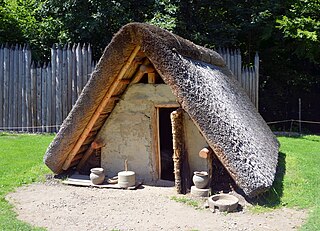
A pit-house is a house built in the ground and used for shelter. Besides providing shelter from the most extreme of weather conditions, these structures may also be used to store food and for cultural activities like the telling of stories, dancing, singing and celebrations. General dictionaries also describe a pit-house as a dugout, and it has similarities to a half-dugout.

Kirkbymoorside is a market town and civil parish in the Ryedale district in North Yorkshire, England. It is 25 miles (40.2 km) north of York, It is also midway between Pickering and Helmsley, on the edge of the North York Moors National Park. It had a population of 3,040 in the 2011 census.

Thor's Cave is a natural cavern located at SK09865496 in the Manifold Valley of the White Peak in Staffordshire, England. It is classified as a karst cave. Located in a steep limestone crag, the cave entrance, a symmetrical arch 7.5 metres wide and 10 metres high, is prominently visible from the valley bottom, around 80 metres (260 feet) below. Reached by an easy stepped path from the Manifold Way, the cave is a popular tourist spot, with views over the Manifold Valley. The second entrance is known as the "West Window", below which is a second cave, Thor's Fissure Cavern.

The Tabon Caves, dubbed as the Philippines' Cradle of Civilization, are a group of caves located on Lipuun Point, north of Quezon municipality, in the south western part of the province of Palawan on Palawan Island, in the Philippines. They are part of the Lipuun Point Reservation, which has been protected by the government of the Philippines as a museum reservation to protect the caves and immediate vicinity from deforestation and to preserve the cultural artifacts present there.
Bluefish Caves is an archaeological site in Yukon, Canada, located 54 km (34 mi) southwest of the Vuntut Gwichin community of Old Crow, from which a jaw bone of a Yukon horse, the extinct Equus lambei. It has been radiocarbon dated to 24,000 years before present (BP). There are three small caves in the area.

The Plum Island Eagle Sanctuary is a 52-acre island in the Illinois River owned by the Illinois Audubon Society. It was purchased March 24, 2004 to act as a wildlife sanctuary, to protect foraging habitat for wintering bald eagles. It is close to Matthiessen State Park and adjacent to Starved Rock State Park.
Prehistoric technology is technology that predates recorded history. History is the study of the past using written records. Anything prior to the first written accounts of history is prehistoric, including earlier technologies. About 2.5 million years before writing was developed, technology began with the earliest hominids who used stone tools, which they may have used to start fires, hunt, and bury their dead.

High Pasture Cave is an archaeological site on the island of Skye, Scotland. Human presence is documented since the Mesolithic, and remains, including Iron Age structures, point to ritual veneration of either the landscape or deities associated with the place. The cave system extends to about 320 metres of accessible passages
Hidden Cave is an archaeological cave site located in the Great Basin near Fallon, Nevada, United States. It got its name from Mark Harrington, who first excavated the cave and had a hard time finding the entrance, who said at the time, "This is one hidden cave!" It was excavated originally in the 1930s by Harrington and then excavated twice more before being returned to for the final time in 1978 by David Hurst Thomas for a more in depth excavation. The site dates back to the early Desert Archaic Culture from c. 4000 to 2000 years ago. Thousands of Archaic artifacts have been found here, and the site "provides important, if unusual clues about Desert Archaic lifeways". Hidden Cave was not lived in, but used as storage site for goods and tools for the 2000 years of its survival.

History Cold Case is a British documentary television series in which scientists use modern forensic techniques to investigate ancient remains. Two series of History Cold Case aired on BBC Two between 6 May 2010 and 21 July 2011. The television series is recommended for age 17 and above due to graphic images and maturity.
Melkhoutboom Cave is an archaeological site dating to the Later Stone Age, located in the Zuurberg Mountains, Cape Folded Mountain Belt, Sarah Baartman District Municipality in the Eastern Cape Province of South Africa.
Dream Cave is a natural limestone cavern located near Wirksworth in Derbyshire, England. It was discovered by lead miners in 1822 and was found to contain the almost complete skeletal remains of a woolly rhinoceros and other large mammal bones. These remains were acquired by the geologist William Buckland and are now housed in Oxford Museum.

Arn Gill is a ravine or gully containing a beck of the same name, near the village of Muker in Swaledale, North Yorkshire, England. The ravine and beck run steeply downhill from the stream's source in Arn Gill Head, and the beck disgorges into the River Swale below.

